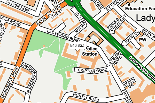
B16 8SZ is located in the Ladywood electoral ward, within the metropolitan district of Birmingham and the English Parliamentary constituency of Birmingham, Ladywood. The Sub Integrated Care Board (ICB) Location is NHS Birmingham and Solihull ICB - 15E and the police force is West Midlands. This postcode has been in use since January 1980.


GetTheData
Source: OS OpenMap – Local (Ordnance Survey)
Source: OS VectorMap District (Ordnance Survey)
Licence: Open Government Licence (requires attribution)
| Easting | 405138 |
| Northing | 286462 |
| Latitude | 52.476079 |
| Longitude | -1.925777 |
GetTheData
Source: Open Postcode Geo
Licence: Open Government Licence
| Country | England |
| Postcode District | B16 |
| ➜ B16 open data dashboard ➜ See where B16 is on a map ➜ Where is Birmingham? | |
GetTheData
Source: Land Registry Price Paid Data
Licence: Open Government Licence
Elevation or altitude of B16 8SZ as distance above sea level:
| Metres | Feet | |
|---|---|---|
| Elevation | 150m | 492ft |
Elevation is measured from the approximate centre of the postcode, to the nearest point on an OS contour line from OS Terrain 50, which has contour spacing of ten vertical metres.
➜ How high above sea level am I? Find the elevation of your current position using your device's GPS.
GetTheData
Source: Open Postcode Elevation
Licence: Open Government Licence
| Ward | Ladywood |
| Constituency | Birmingham, Ladywood |
GetTheData
Source: ONS Postcode Database
Licence: Open Government Licence
| January 2024 | Violence and sexual offences | On or near Rann Close | 190m |
| January 2024 | Vehicle crime | On or near Parking Area | 273m |
| January 2024 | Vehicle crime | On or near Parking Area | 273m |
| ➜ Get more crime data in our Crime section | |||
GetTheData
Source: data.police.uk
Licence: Open Government Licence
| Ladywood Social Club (Ladywood Middleway) | Ladywood | 131m |
| Darnley Rd (Alston St) | Ladywood | 155m |
| Darnley Rd (Alston St) | Ladywood | 183m |
| Ladywood Social Club (Ladywood Middleway) | Ladywood | 193m |
| Ladywood Fire Station (Wood St) | Ladywood | 227m |
| St Paul's (Midland Metro Stop) (Livery Street) | Jewellery Quarter | 1,895m |
| Five Ways Station | 1km |
| Jewellery Quarter Station | 1.7km |
| Birmingham New Street Station | 1.7km |
GetTheData
Source: NaPTAN
Licence: Open Government Licence
GetTheData
Source: ONS Postcode Database
Licence: Open Government Licence


➜ Get more ratings from the Food Standards Agency
GetTheData
Source: Food Standards Agency
Licence: FSA terms & conditions
| Last Collection | |||
|---|---|---|---|
| Location | Mon-Fri | Sat | Distance |
| Hagley Road Post Office | 17:45 | 12:30 | 213m |
| St Vincent St Post Office | 17:30 | 12:30 | 260m |
| 53 Reservoir Road | 17:30 | 12:30 | 349m |
GetTheData
Source: Dracos
Licence: Creative Commons Attribution-ShareAlike
| Facility | Distance |
|---|---|
| St Georges C Of E Primary School (Edgbaston) Beaufort Road, Edgbaston, Birmingham Sports Hall, Artificial Grass Pitch | 372m |
| Nuffield Health (Birmingham Central) Ladywood Middleway, Birmingham Swimming Pool, Health and Fitness Gym, Studio | 397m |
| Ladywood Leisure Centre Ladywood Middleway, Birmingham Swimming Pool, Health and Fitness Gym, Studio | 412m |
GetTheData
Source: Active Places
Licence: Open Government Licence
| School | Phase of Education | Distance |
|---|---|---|
| The Oratory Roman Catholic Primary School Oliver Road, Ladywood, Birmingham, B16 9ER | Primary | 242m |
| St John's & St Peter's CofE Academy St Vincent Street West, Ladywood, Birmingham, B16 8RN | Primary | 276m |
| St George's Church of England Primary School Beaufort Road, Edgbaston, Birmingham, B16 8HY | Primary | 372m |
GetTheData
Source: Edubase
Licence: Open Government Licence
The below table lists the International Territorial Level (ITL) codes (formerly Nomenclature of Territorial Units for Statistics (NUTS) codes) and Local Administrative Units (LAU) codes for B16 8SZ:
| ITL 1 Code | Name |
|---|---|
| TLG | West Midlands (England) |
| ITL 2 Code | Name |
| TLG3 | West Midlands |
| ITL 3 Code | Name |
| TLG31 | Birmingham |
| LAU 1 Code | Name |
| E08000025 | Birmingham |
GetTheData
Source: ONS Postcode Directory
Licence: Open Government Licence
The below table lists the Census Output Area (OA), Lower Layer Super Output Area (LSOA), and Middle Layer Super Output Area (MSOA) for B16 8SZ:
| Code | Name | |
|---|---|---|
| OA | E00046387 | |
| LSOA | E01009143 | Birmingham 136A |
| MSOA | E02006897 | Birmingham 136 |
GetTheData
Source: ONS Postcode Directory
Licence: Open Government Licence
| B16 8RT | Ledbury Close | 129m |
| B16 8SW | Power Crescent | 131m |
| B16 8JL | Skipton Road | 149m |
| B16 8JN | Skipton Road | 152m |
| B16 8JW | Skipton Road | 160m |
| B16 8DX | Guild Close | 189m |
| B16 8JH | Skipton Road | 192m |
| B16 8JR | Huntly Road | 198m |
| B16 8SN | Francis Road | 207m |
| B16 8JP | Huntly Road | 212m |
GetTheData
Source: Open Postcode Geo; Land Registry Price Paid Data
Licence: Open Government Licence