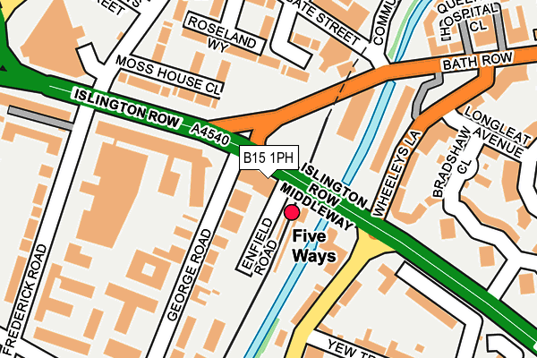
B15 1PH is located in the Edgbaston electoral ward, within the metropolitan district of Birmingham and the English Parliamentary constituency of Birmingham, Edgbaston. The Sub Integrated Care Board (ICB) Location is NHS Birmingham and Solihull ICB - 15E and the police force is West Midlands. This postcode has been in use since February 2010.


GetTheData
Source: OS OpenMap – Local (Ordnance Survey)
Source: OS VectorMap District (Ordnance Survey)
Licence: Open Government Licence (requires attribution)
| Easting | 405979 |
| Northing | 285953 |
| Latitude | 52.471480 |
| Longitude | -1.913410 |
GetTheData
Source: Open Postcode Geo
Licence: Open Government Licence
| Country | England |
| Postcode District | B15 |
| ➜ B15 open data dashboard ➜ See where B15 is on a map ➜ Where is Birmingham? | |
GetTheData
Source: Land Registry Price Paid Data
Licence: Open Government Licence
Elevation or altitude of B15 1PH as distance above sea level:
| Metres | Feet | |
|---|---|---|
| Elevation | 140m | 459ft |
Elevation is measured from the approximate centre of the postcode, to the nearest point on an OS contour line from OS Terrain 50, which has contour spacing of ten vertical metres.
➜ How high above sea level am I? Find the elevation of your current position using your device's GPS.
GetTheData
Source: Open Postcode Elevation
Licence: Open Government Licence
| Ward | Edgbaston |
| Constituency | Birmingham, Edgbaston |
GetTheData
Source: ONS Postcode Database
Licence: Open Government Licence
| January 2024 | Anti-social behaviour | On or near Parking Area | 275m |
| January 2024 | Criminal damage and arson | On or near Parking Area | 275m |
| January 2024 | Violence and sexual offences | On or near Parking Area | 275m |
| ➜ Get more crime data in our Crime section | |||
GetTheData
Source: data.police.uk
Licence: Open Government Licence
| Five Ways Station (Islington Row) | Birmingham | 70m |
| Five Ways Station (Bath Row) | Birmingham | 73m |
| Five Ways Station (Islington Row) | Birmingham | 149m |
| Islington Row Middleway (Frederick Rd) | Five Ways | 229m |
| Bexhill Grove (Bath Row) | Lee Bank | 238m |
| Grand Central New Street (Midland Metro Stop) (Stephenson Street) | Birmingham | 1,244m |
| Corporation Street (Midland Metro Stop) (Corporation Street) | Birmingham | 1,443m |
| Bull Street (Midland Metro Stop) (Bull Street) | Birmingham | 1,638m |
| Snow Hill (Midland Metro Stop) (Colmore Row) | Birmingham | 1,658m |
| Five Ways Station | 0.1km |
| Birmingham New Street Station | 1.1km |
| Birmingham Snow Hill Station | 1.6km |
GetTheData
Source: NaPTAN
Licence: Open Government Licence
GetTheData
Source: ONS Postcode Database
Licence: Open Government Licence

➜ Get more ratings from the Food Standards Agency
GetTheData
Source: Food Standards Agency
Licence: FSA terms & conditions
| Last Collection | |||
|---|---|---|---|
| Location | Mon-Fri | Sat | Distance |
| Edgaston Post Office | 18:30 | 12:15 | 227m |
| Granville Square | 16:45 | 12:30 | 313m |
| St James Road / Wheeleys Road | 18:30 | 12:30 | 324m |
GetTheData
Source: Dracos
Licence: Creative Commons Attribution-ShareAlike
| Facility | Distance |
|---|---|
| Puregym (Birmingham City Centre) Broad Street, Birmingham Health and Fitness Gym, Studio | 335m |
| The Gym Group (Birmingham Broad Street) Broadway, Ladywood Middleway, Birmingham Health and Fitness Gym | 397m |
| University College Birmingham - The Maltings Granville Street, Birmingham Sports Hall, Health and Fitness Gym | 421m |
GetTheData
Source: Active Places
Licence: Open Government Licence
| School | Phase of Education | Distance |
|---|---|---|
| Edgbaston College 37 George Road, Birmingham, B15 1PL | Not applicable | 187m |
| West House School 24 St James's Road, Edgbaston, Birmingham, B15 2NX | Not applicable | 425m |
| City Academy 23 Langley Walk, Birmingham, B15 2EF | Secondary | 465m |
GetTheData
Source: Edubase
Licence: Open Government Licence
The below table lists the International Territorial Level (ITL) codes (formerly Nomenclature of Territorial Units for Statistics (NUTS) codes) and Local Administrative Units (LAU) codes for B15 1PH:
| ITL 1 Code | Name |
|---|---|
| TLG | West Midlands (England) |
| ITL 2 Code | Name |
| TLG3 | West Midlands |
| ITL 3 Code | Name |
| TLG31 | Birmingham |
| LAU 1 Code | Name |
| E08000025 | Birmingham |
GetTheData
Source: ONS Postcode Directory
Licence: Open Government Licence
The below table lists the Census Output Area (OA), Lower Layer Super Output Area (LSOA), and Middle Layer Super Output Area (MSOA) for B15 1PH:
| Code | Name | |
|---|---|---|
| OA | E00045607 | |
| LSOA | E01008994 | Birmingham 074B |
| MSOA | E02001900 | Birmingham 074 |
GetTheData
Source: ONS Postcode Directory
Licence: Open Government Licence
| B15 1PL | George Road | 29m |
| B15 1PT | George Road | 59m |
| B15 1HF | Moss House Close | 149m |
| B15 2BE | Lee Bank Middleway | 152m |
| B15 1HE | Moss House Close | 155m |
| B15 2LN | Wheeleys Road | 160m |
| B15 2DW | Wheeleys Lane | 162m |
| B15 1HD | Roseland Way | 164m |
| B15 1HB | Shepherds Gardens | 166m |
| B15 2LD | Wheeleys Road | 172m |
GetTheData
Source: Open Postcode Geo; Land Registry Price Paid Data
Licence: Open Government Licence