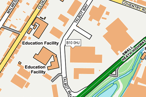
B10 0HJ lies on Talbot Way in Birmingham. B10 0HJ is located in the Small Heath electoral ward, within the metropolitan district of Birmingham and the English Parliamentary constituency of Birmingham, Yardley. The Sub Integrated Care Board (ICB) Location is NHS Birmingham and Solihull ICB - 15E and the police force is West Midlands. This postcode has been in use since September 1991.


GetTheData
Source: OS OpenMap – Local (Ordnance Survey)
Source: OS VectorMap District (Ordnance Survey)
Licence: Open Government Licence (requires attribution)
| Easting | 410609 |
| Northing | 284997 |
| Latitude | 52.462831 |
| Longitude | -1.845275 |
GetTheData
Source: Open Postcode Geo
Licence: Open Government Licence
| Street | Talbot Way |
| Town/City | Birmingham |
| Country | England |
| Postcode District | B10 |
| ➜ B10 open data dashboard ➜ See where B10 is on a map ➜ Where is Birmingham? | |
GetTheData
Source: Land Registry Price Paid Data
Licence: Open Government Licence
Elevation or altitude of B10 0HJ as distance above sea level:
| Metres | Feet | |
|---|---|---|
| Elevation | 110m | 361ft |
Elevation is measured from the approximate centre of the postcode, to the nearest point on an OS contour line from OS Terrain 50, which has contour spacing of ten vertical metres.
➜ How high above sea level am I? Find the elevation of your current position using your device's GPS.
GetTheData
Source: Open Postcode Elevation
Licence: Open Government Licence
| Ward | Small Heath |
| Constituency | Birmingham, Yardley |
GetTheData
Source: ONS Postcode Database
Licence: Open Government Licence
| January 2024 | Anti-social behaviour | On or near Petrol Station | 271m |
| January 2024 | Anti-social behaviour | On or near Petrol Station | 271m |
| January 2024 | Anti-social behaviour | On or near Petrol Station | 271m |
| ➜ Get more crime data in our Crime section | |||
GetTheData
Source: data.police.uk
Licence: Open Government Licence
| Coventry Rd (Oldknow Rd) | Small Heath | 269m |
| Asda (Coventry Rd) | Hay Mills | 295m |
| Coventry Rd (Oldknow Rd) | Small Heath | 315m |
| St Benedicts Rd (Coventry Rd) | Small Heath | 320m |
| Asda (Coventry Rd) | Hay Mills | 327m |
| Small Heath Station | 1km |
| Tyseley Station | 1.1km |
| Spring Road Station | 2.2km |
GetTheData
Source: NaPTAN
Licence: Open Government Licence
GetTheData
Source: ONS Postcode Database
Licence: Open Government Licence

➜ Get more ratings from the Food Standards Agency
GetTheData
Source: Food Standards Agency
Licence: FSA terms & conditions
| Last Collection | |||
|---|---|---|---|
| Location | Mon-Fri | Sat | Distance |
| Monica Road Coventry Road | 17:30 | 11:30 | 340m |
| Tennyson Road | 17:30 | 11:30 | 509m |
| Brunton Road | 17:30 | 11:30 | 540m |
GetTheData
Source: Dracos
Licence: Creative Commons Attribution-ShareAlike
| Facility | Distance |
|---|---|
| Ark Victoria Academy Talbot Way, Birmingham Sports Hall, Artificial Grass Pitch | 66m |
| D's Muscle 'n' Fitness Kings Road, South Yardley, Birmingham Health and Fitness Gym, Studio | 586m |
| The Ackers Golden Hillock Road, Sparkbrook, Birmingham Ski Slopes | 696m |
GetTheData
Source: Active Places
Licence: Open Government Licence
| School | Phase of Education | Distance |
|---|---|---|
| Ark Victoria Academy Talbot Way, Small Heath, Birmingham, B10 0HJ | All-through | 71m |
| Holy Family Catholic Primary School Coventry Road, Small Heath, Birmingham, B10 0HT | Primary | 308m |
| St Benedict's Primary School St Benedict's Road, Birmingham, B10 9DP | Primary | 456m |
GetTheData
Source: Edubase
Licence: Open Government Licence
The below table lists the International Territorial Level (ITL) codes (formerly Nomenclature of Territorial Units for Statistics (NUTS) codes) and Local Administrative Units (LAU) codes for B10 0HJ:
| ITL 1 Code | Name |
|---|---|
| TLG | West Midlands (England) |
| ITL 2 Code | Name |
| TLG3 | West Midlands |
| ITL 3 Code | Name |
| TLG31 | Birmingham |
| LAU 1 Code | Name |
| E08000025 | Birmingham |
GetTheData
Source: ONS Postcode Directory
Licence: Open Government Licence
The below table lists the Census Output Area (OA), Lower Layer Super Output Area (LSOA), and Middle Layer Super Output Area (MSOA) for B10 0HJ:
| Code | Name | |
|---|---|---|
| OA | E00047324 | |
| LSOA | E01009338 | Birmingham 070D |
| MSOA | E02001896 | Birmingham 070 |
GetTheData
Source: ONS Postcode Directory
Licence: Open Government Licence
| B10 0HX | Oldknow Road | 243m |
| B10 0HU | Oldknow Road | 257m |
| B10 0JB | Oldknow Road | 265m |
| B10 0HR | Sapcote Trading Centre | 274m |
| B10 0JA | Oldknow Road | 278m |
| B10 0JE | Malmesbury Road | 325m |
| B10 0TY | Coventry Road | 331m |
| B10 0JF | Malmesbury Road | 335m |
| B10 0TX | Coventry Road | 352m |
| B10 0JJ | Malmesbury Road | 356m |
GetTheData
Source: Open Postcode Geo; Land Registry Price Paid Data
Licence: Open Government Licence