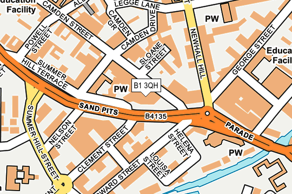
B1 3QH is located in the Soho & Jewellery Quarter electoral ward, within the metropolitan district of Birmingham and the English Parliamentary constituency of Birmingham, Ladywood. The Sub Integrated Care Board (ICB) Location is NHS Birmingham and Solihull ICB - 15E and the police force is West Midlands. This postcode has been in use since January 1980.


GetTheData
Source: OS OpenMap – Local (Ordnance Survey)
Source: OS VectorMap District (Ordnance Survey)
Licence: Open Government Licence (requires attribution)
| Easting | 406032 |
| Northing | 287188 |
| Latitude | 52.482582 |
| Longitude | -1.912608 |
GetTheData
Source: Open Postcode Geo
Licence: Open Government Licence
| Country | England |
| Postcode District | B1 |
| ➜ B1 open data dashboard ➜ See where B1 is on a map ➜ Where is Birmingham? | |
GetTheData
Source: Land Registry Price Paid Data
Licence: Open Government Licence
Elevation or altitude of B1 3QH as distance above sea level:
| Metres | Feet | |
|---|---|---|
| Elevation | 130m | 427ft |
Elevation is measured from the approximate centre of the postcode, to the nearest point on an OS contour line from OS Terrain 50, which has contour spacing of ten vertical metres.
➜ How high above sea level am I? Find the elevation of your current position using your device's GPS.
GetTheData
Source: Open Postcode Elevation
Licence: Open Government Licence
| Ward | Soho & Jewellery Quarter |
| Constituency | Birmingham, Ladywood |
GetTheData
Source: ONS Postcode Database
Licence: Open Government Licence
| January 2024 | Possession of weapons | On or near Daley Close | 393m |
| January 2024 | Criminal damage and arson | On or near St Marks Crescent | 399m |
| January 2024 | Criminal damage and arson | On or near St Marks Crescent | 399m |
| ➜ Get more crime data in our Crime section | |||
GetTheData
Source: data.police.uk
Licence: Open Government Licence
| Nelson St (Sandpits) | National Indoor Arena | 76m |
| George St (Newhall Hill) | National Indoor Arena | 128m |
| Townsend Way (Clement St) | National Indoor Arena | 160m |
| Nelson St (Sandpits) | National Indoor Arena | 182m |
| Charlotte St (Parade) | National Indoor Arena | 206m |
| St Paul's (Midland Metro Stop) (Livery Street) | Jewellery Quarter | 744m |
| Jewellery Quarter (Midland Metro Stop) (Vyse St Hockley) | Jewellery Quarter | 788m |
| Snow Hill (Midland Metro Stop) (Colmore Row) | Birmingham | 920m |
| Grand Central New Street (Midland Metro Stop) (Stephenson Street) | Birmingham | 1,005m |
| Corporation Street (Midland Metro Stop) (Corporation Street) | Birmingham | 1,091m |
| Jewellery Quarter Station | 0.8km |
| Birmingham Snow Hill Station | 0.9km |
| Birmingham New Street Station | 1km |
GetTheData
Source: NaPTAN
Licence: Open Government Licence
GetTheData
Source: ONS Postcode Database
Licence: Open Government Licence
➜ Get more ratings from the Food Standards Agency
GetTheData
Source: Food Standards Agency
Licence: FSA terms & conditions
| Last Collection | |||
|---|---|---|---|
| Location | Mon-Fri | Sat | Distance |
| The Parade Summerhill Road | 17:30 | 12:30 | 187m |
| Frederick St / Legge Lane | 18:30 | 12:30 | 216m |
| Clement St / King Edwards St | 18:30 | 12:30 | 220m |
GetTheData
Source: Dracos
Licence: Creative Commons Attribution-ShareAlike
| Facility | Distance |
|---|---|
| National Indoor Arena Birmingham Community Hall (Closed) King Edwards Road, Birmingham Sports Hall, Health and Fitness Gym | 335m |
| Bannatyne Health Club (Birmingham Brindley Place) Brunswick Street, Birmingham Swimming Pool, Health and Fitness Gym, Studio | 471m |
| The Copthorne Hotel Paradise Place, Birmingham Health and Fitness Gym, Swimming Pool | 497m |
GetTheData
Source: Active Places
Licence: Open Government Licence
| School | Phase of Education | Distance |
|---|---|---|
| City United Academy (CUA) 10 Edward Street, Birmingham, Birmingham, Birmingham, B1 2RX | Not applicable | 184m |
| Jewellery Quarter Academy St George's Court, 1 Albion Street, Birmingham, B1 3AA | Secondary | 260m |
| Nelson Junior and Infant School King Edward's Road, Ladywood, Birmingham, B1 2PJ | Primary | 279m |
GetTheData
Source: Edubase
Licence: Open Government Licence
The below table lists the International Territorial Level (ITL) codes (formerly Nomenclature of Territorial Units for Statistics (NUTS) codes) and Local Administrative Units (LAU) codes for B1 3QH:
| ITL 1 Code | Name |
|---|---|
| TLG | West Midlands (England) |
| ITL 2 Code | Name |
| TLG3 | West Midlands |
| ITL 3 Code | Name |
| TLG31 | Birmingham |
| LAU 1 Code | Name |
| E08000025 | Birmingham |
GetTheData
Source: ONS Postcode Directory
Licence: Open Government Licence
The below table lists the Census Output Area (OA), Lower Layer Super Output Area (LSOA), and Middle Layer Super Output Area (MSOA) for B1 3QH:
| Code | Name | |
|---|---|---|
| OA | E00175684 | |
| LSOA | E01033565 | Birmingham 137B |
| MSOA | E02006898 | Birmingham 137 |
GetTheData
Source: ONS Postcode Directory
Licence: Open Government Licence
| B1 2SN | Clement Street | 66m |
| B1 3RA | Summer Hill Terrace | 79m |
| B1 2EL | Edward Street | 116m |
| B1 3JN | Newhall Hill | 127m |
| B1 2RT | Townsend Way | 128m |
| B1 3DB | Arthur Place | 130m |
| B1 3JP | Newhall Hill | 140m |
| B1 2RR | Scotland Street | 142m |
| B1 3JA | Newhall Hill | 155m |
| B1 2EJ | Scotland Street | 159m |
GetTheData
Source: Open Postcode Geo; Land Registry Price Paid Data
Licence: Open Government Licence