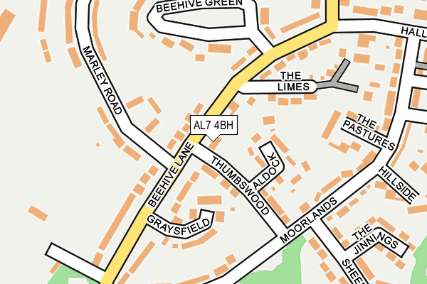
AL7 4BH is located in the Howlands electoral ward, within the local authority district of Welwyn Hatfield and the English Parliamentary constituency of Welwyn Hatfield. The Sub Integrated Care Board (ICB) Location is NHS Hertfordshire and West Essex ICB - 06K and the police force is Hertfordshire. This postcode has been in use since January 1980.


GetTheData
Source: OS OpenMap – Local (Ordnance Survey)
Source: OS VectorMap District (Ordnance Survey)
Licence: Open Government Licence (requires attribution)
| Easting | 525291 |
| Northing | 211496 |
| Latitude | 51.788100 |
| Longitude | -0.184894 |
GetTheData
Source: Open Postcode Geo
Licence: Open Government Licence
| Country | England |
| Postcode District | AL7 |
| ➜ AL7 open data dashboard ➜ See where AL7 is on a map ➜ Where is Welwyn Garden City? | |
GetTheData
Source: Land Registry Price Paid Data
Licence: Open Government Licence
Elevation or altitude of AL7 4BH as distance above sea level:
| Metres | Feet | |
|---|---|---|
| Elevation | 70m | 230ft |
Elevation is measured from the approximate centre of the postcode, to the nearest point on an OS contour line from OS Terrain 50, which has contour spacing of ten vertical metres.
➜ How high above sea level am I? Find the elevation of your current position using your device's GPS.
GetTheData
Source: Open Postcode Elevation
Licence: Open Government Licence
| Ward | Howlands |
| Constituency | Welwyn Hatfield |
GetTheData
Source: ONS Postcode Database
Licence: Open Government Licence
| October 2023 | Anti-social behaviour | On or near Hillside | 262m |
| August 2023 | Violence and sexual offences | On or near Hillside | 262m |
| February 2023 | Criminal damage and arson | On or near Sheepcote | 290m |
| ➜ Get more crime data in our Crime section | |||
GetTheData
Source: data.police.uk
Licence: Open Government Licence
| Thumbswood (Beehive Lane) | Welwyn Garden City | 30m |
| Thumbswood (Beehive Lane) | Welwyn Garden City | 55m |
| Beehive Green (Beehive Lane) | Welwyn Garden City | 211m |
| Beehive Green (Beehive Lane) | Welwyn Garden City | 222m |
| Sweet Briar (Cole Green Lane) | Welwyn Garden City | 264m |
| Welwyn Garden City Station | 2km |
| Hatfield (Herts) Station | 3.4km |
| Welwyn North Station | 4km |
GetTheData
Source: NaPTAN
Licence: Open Government Licence
GetTheData
Source: ONS Postcode Database
Licence: Open Government Licence


➜ Get more ratings from the Food Standards Agency
GetTheData
Source: Food Standards Agency
Licence: FSA terms & conditions
| Last Collection | |||
|---|---|---|---|
| Location | Mon-Fri | Sat | Distance |
| Beehive Lane | 17:30 | 12:00 | 248m |
| Wheatley Road | 17:30 | 11:45 | 304m |
| Hallgrove P.o | 17:30 | 12:00 | 330m |
GetTheData
Source: Dracos
Licence: Creative Commons Attribution-ShareAlike
| Facility | Distance |
|---|---|
| King George V Playing Fields (Welwyn Garden City) Beehive Lane, Welwyn Garden City Grass Pitches, Outdoor Tennis Courts, Artificial Grass Pitch | 274m |
| Swallow Dell Primary And Nursery School Blackthorn Road, Welwyn Garden City Grass Pitches | 770m |
| Hatfield And Crusaders Cricket Club Ascots Lane, Welwyn Garden City Grass Pitches | 889m |
GetTheData
Source: Active Places
Licence: Open Government Licence
| School | Phase of Education | Distance |
|---|---|---|
| Commonswood Primary & Nursery School The Commons, WELWYN GARDEN CITY, AL7 4RU | Primary | 661m |
| Swallow Dell Primary and Nursery School Blackthorn Road, Welwyn Garden City, AL7 3JP | Primary | 779m |
| Holwell Primary School Holwell Road, Welwyn Garden City, AL7 3RP | Primary | 946m |
GetTheData
Source: Edubase
Licence: Open Government Licence
The below table lists the International Territorial Level (ITL) codes (formerly Nomenclature of Territorial Units for Statistics (NUTS) codes) and Local Administrative Units (LAU) codes for AL7 4BH:
| ITL 1 Code | Name |
|---|---|
| TLH | East |
| ITL 2 Code | Name |
| TLH2 | Bedfordshire and Hertfordshire |
| ITL 3 Code | Name |
| TLH23 | Hertfordshire CC |
| LAU 1 Code | Name |
| E07000241 | Welwyn Hatfield |
GetTheData
Source: ONS Postcode Directory
Licence: Open Government Licence
The below table lists the Census Output Area (OA), Lower Layer Super Output Area (LSOA), and Middle Layer Super Output Area (MSOA) for AL7 4BH:
| Code | Name | |
|---|---|---|
| OA | E00121591 | |
| LSOA | E01023946 | Welwyn Hatfield 008D |
| MSOA | E02004987 | Welwyn Hatfield 008 |
GetTheData
Source: ONS Postcode Directory
Licence: Open Government Licence
| AL7 4BQ | Beehive Lane | 51m |
| AL7 4QE | Thumbswood | 96m |
| AL7 4QF | Aldock | 97m |
| AL7 4BL | Graysfield | 109m |
| AL7 4BB | Beehive Lane | 146m |
| AL7 4BE | Beehive Green | 158m |
| AL7 4PX | The Pastures | 168m |
| AL7 4BJ | Beehive Lane | 170m |
| AL7 4BS | Marley Road | 174m |
| AL7 4BP | Beehive Lane | 177m |
GetTheData
Source: Open Postcode Geo; Land Registry Price Paid Data
Licence: Open Government Licence