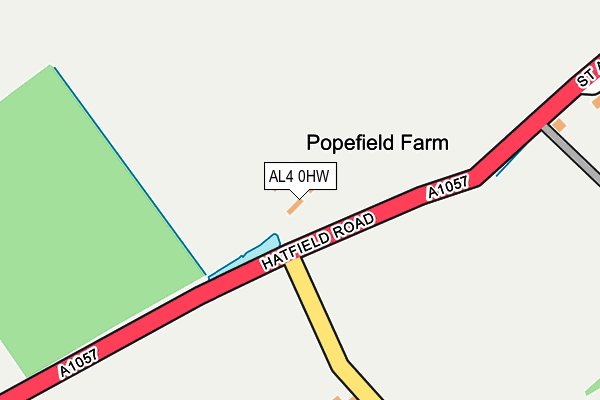
AL4 0HW is located in the Colney Heath electoral ward, within the local authority district of St Albans and the English Parliamentary constituency of St Albans. The Sub Integrated Care Board (ICB) Location is NHS Hertfordshire and West Essex ICB - 06N and the police force is Hertfordshire. This postcode has been in use since January 1980.


GetTheData
Source: OS OpenMap – Local (Ordnance Survey)
Source: OS VectorMap District (Ordnance Survey)
Licence: Open Government Licence (requires attribution)
| Easting | 520094 |
| Northing | 207987 |
| Latitude | 51.757709 |
| Longitude | -0.261392 |
GetTheData
Source: Open Postcode Geo
Licence: Open Government Licence
| Country | England |
| Postcode District | AL4 |
| ➜ AL4 open data dashboard ➜ See where AL4 is on a map | |
GetTheData
Source: Land Registry Price Paid Data
Licence: Open Government Licence
Elevation or altitude of AL4 0HW as distance above sea level:
| Metres | Feet | |
|---|---|---|
| Elevation | 80m | 262ft |
Elevation is measured from the approximate centre of the postcode, to the nearest point on an OS contour line from OS Terrain 50, which has contour spacing of ten vertical metres.
➜ How high above sea level am I? Find the elevation of your current position using your device's GPS.
GetTheData
Source: Open Postcode Elevation
Licence: Open Government Licence
| Ward | Colney Heath |
| Constituency | St Albans |
GetTheData
Source: ONS Postcode Database
Licence: Open Government Licence
| May 2021 | Other theft | On or near Wilkin'S Green Lane | 400m |
| ➜ Get more crime data in our Crime section | |||
GetTheData
Source: data.police.uk
Licence: Open Government Licence
| Great Nast Hyde (St Albans Road) | Ellenbrook | 274m |
| Great Nast Hyde (St Albans Road) | Ellenbrook | 317m |
| Three Horseshoes Ph (Hatfield Road) | Smallford | 576m |
| Three Horseshoes Ph (Hatfield Road) | Smallford | 598m |
| Smallford Roundabout (Station Road) | Smallford | 629m |
| Hatfield (Herts) Station | 3.2km |
| Welham Green Station | 4.2km |
| St Albans City Station | 4.6km |
GetTheData
Source: NaPTAN
Licence: Open Government Licence
GetTheData
Source: ONS Postcode Database
Licence: Open Government Licence


➜ Get more ratings from the Food Standards Agency
GetTheData
Source: Food Standards Agency
Licence: FSA terms & conditions
| Last Collection | |||
|---|---|---|---|
| Location | Mon-Fri | Sat | Distance |
| Poplars | 17:00 | 12:00 | 545m |
| Ellenbrook Lane | 17:00 | 12:00 | 845m |
| College Lane | 17:00 | 12:00 | 1,341m |
GetTheData
Source: Dracos
Licence: Creative Commons Attribution-ShareAlike
| Facility | Distance |
|---|---|
| St Albans Rfc Oaklands Lane, Smallford, St. Albans Grass Pitches | 808m |
| Harvesters Football Club Oaklands Lane, Smallford, St Albans Grass Pitches, Artificial Grass Pitch | 846m |
| Hertfordshire Sports Village Mosquito Way, Hatfield Sports Hall, Swimming Pool, Health and Fitness Gym, Artificial Grass Pitch, Grass Pitches, Studio, Squash Courts | 981m |
GetTheData
Source: Active Places
Licence: Open Government Licence
| School | Phase of Education | Distance |
|---|---|---|
| University of Hertfordshire Hatfield Campus, College Lane, Hatfield, AL10 9AB | Not applicable | 1.4km |
| Howe Dell Primary School The Runway, Hatfield, AL10 9AH | Primary | 1.5km |
| Colney Heath Junior Mixed Infant and Nursery School High Street, Colney Heath, St Albans, AL4 0NP | Primary | 1.8km |
GetTheData
Source: Edubase
Licence: Open Government Licence
The below table lists the International Territorial Level (ITL) codes (formerly Nomenclature of Territorial Units for Statistics (NUTS) codes) and Local Administrative Units (LAU) codes for AL4 0HW:
| ITL 1 Code | Name |
|---|---|
| TLH | East |
| ITL 2 Code | Name |
| TLH2 | Bedfordshire and Hertfordshire |
| ITL 3 Code | Name |
| TLH23 | Hertfordshire CC |
| LAU 1 Code | Name |
| E07000240 | St Albans |
GetTheData
Source: ONS Postcode Directory
Licence: Open Government Licence
The below table lists the Census Output Area (OA), Lower Layer Super Output Area (LSOA), and Middle Layer Super Output Area (MSOA) for AL4 0HW:
| Code | Name | |
|---|---|---|
| OA | E00120252 | |
| LSOA | E01023680 | St Albans 015D |
| MSOA | E02004938 | St Albans 015 |
GetTheData
Source: ONS Postcode Directory
Licence: Open Government Licence
| AL4 0HG | Wilkins Green | 320m |
| AL10 9RU | St Albans Road West | 404m |
| AL10 9SD | Bramble Road | 438m |
| AL10 9SB | Bramble Road | 463m |
| AL10 9SF | Poplar Avenue | 529m |
| AL10 9SE | Bramble Road | 531m |
| AL4 0HP | Hatfield Road | 544m |
| AL4 0HJ | Springfield Road | 553m |
| AL10 9SA | Bramble Road | 599m |
| AL4 0HH | Springfield Road | 603m |
GetTheData
Source: Open Postcode Geo; Land Registry Price Paid Data
Licence: Open Government Licence