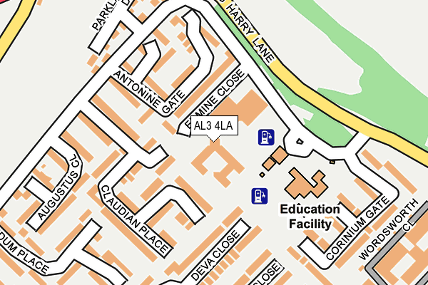
AL3 4LA is located in the Verulam electoral ward, within the local authority district of St Albans and the English Parliamentary constituency of St Albans. The Sub Integrated Care Board (ICB) Location is NHS Hertfordshire and West Essex ICB - 06N and the police force is Hertfordshire. This postcode has been in use since January 1980.


GetTheData
Source: OS OpenMap – Local (Ordnance Survey)
Source: OS VectorMap District (Ordnance Survey)
Licence: Open Government Licence (requires attribution)
| Easting | 513268 |
| Northing | 206535 |
| Latitude | 51.746081 |
| Longitude | -0.360720 |
GetTheData
Source: Open Postcode Geo
Licence: Open Government Licence
| Country | England |
| Postcode District | AL3 |
| ➜ AL3 open data dashboard ➜ See where AL3 is on a map ➜ Where is St Albans? | |
GetTheData
Source: Land Registry Price Paid Data
Licence: Open Government Licence
Elevation or altitude of AL3 4LA as distance above sea level:
| Metres | Feet | |
|---|---|---|
| Elevation | 110m | 361ft |
Elevation is measured from the approximate centre of the postcode, to the nearest point on an OS contour line from OS Terrain 50, which has contour spacing of ten vertical metres.
➜ How high above sea level am I? Find the elevation of your current position using your device's GPS.
GetTheData
Source: Open Postcode Elevation
Licence: Open Government Licence
| Ward | Verulam |
| Constituency | St Albans |
GetTheData
Source: ONS Postcode Database
Licence: Open Government Licence
| October 2023 | Vehicle crime | On or near Deva Close | 148m |
| October 2023 | Burglary | On or near Deva Close | 148m |
| September 2023 | Anti-social behaviour | On or near Claudian Place | 97m |
| ➜ Get more crime data in our Crime section | |||
GetTheData
Source: data.police.uk
Licence: Open Government Licence
| Roman Gate (King Harry Lane) | Verulam | 155m |
| Waitrose (Mayne Avenue) | Verulam | 159m |
| Roman Gate (King Harry Lane) | Verulam | 166m |
| Augustus Close (Mayne Avenue) | Verulam | 237m |
| Bedmond Lane (Hemel Hempstead Road) | St Albans | 396m |
| St Albans Abbey Station | 1.3km |
| St Albans City Station | 2.3km |
| Park Street Station | 2.7km |
GetTheData
Source: NaPTAN
Licence: Open Government Licence
| Percentage of properties with Next Generation Access | 100.0% |
| Percentage of properties with Superfast Broadband | 100.0% |
| Percentage of properties with Ultrafast Broadband | 0.0% |
| Percentage of properties with Full Fibre Broadband | 0.0% |
Superfast Broadband is between 30Mbps and 300Mbps
Ultrafast Broadband is > 300Mbps
| Percentage of properties unable to receive 2Mbps | 0.0% |
| Percentage of properties unable to receive 5Mbps | 0.0% |
| Percentage of properties unable to receive 10Mbps | 0.0% |
| Percentage of properties unable to receive 30Mbps | 0.0% |
GetTheData
Source: Ofcom
Licence: Ofcom Terms of Use (requires attribution)
GetTheData
Source: ONS Postcode Database
Licence: Open Government Licence


➜ Get more ratings from the Food Standards Agency
GetTheData
Source: Food Standards Agency
Licence: FSA terms & conditions
| Last Collection | |||
|---|---|---|---|
| Location | Mon-Fri | Sat | Distance |
| Mayne Avenue South | 17:30 | 12:00 | 379m |
| St Michaels/Fishpool Street | 17:30 | 12:00 | 916m |
| Fishpool Street | 17:30 | 12:00 | 1,099m |
GetTheData
Source: Dracos
Licence: Creative Commons Attribution-ShareAlike
| Facility | Distance |
|---|---|
| Prae Wood Primary School King Harry Lane, St. Albans Grass Pitches | 124m |
| Verulamium Park St. Michaels, St. Albans Grass Pitches | 522m |
| St Columba's College King Harry Lane, St. Albans Health and Fitness Gym, Grass Pitches, Sports Hall, Outdoor Tennis Courts | 866m |
GetTheData
Source: Active Places
Licence: Open Government Licence
| School | Phase of Education | Distance |
|---|---|---|
| Prae Wood Primary School King Harry Lane, St Albans, AL3 4HZ | Primary | 131m |
| St Columba's College King Harry Lane, St Albans, AL3 4AW | Not applicable | 767m |
| St Michael's Church of England Voluntary Aided Primary School, St Albans St Michael's Street, St Albans, AL3 4SJ | Primary | 867m |
GetTheData
Source: Edubase
Licence: Open Government Licence
The below table lists the International Territorial Level (ITL) codes (formerly Nomenclature of Territorial Units for Statistics (NUTS) codes) and Local Administrative Units (LAU) codes for AL3 4LA:
| ITL 1 Code | Name |
|---|---|
| TLH | East |
| ITL 2 Code | Name |
| TLH2 | Bedfordshire and Hertfordshire |
| ITL 3 Code | Name |
| TLH23 | Hertfordshire CC |
| LAU 1 Code | Name |
| E07000240 | St Albans |
GetTheData
Source: ONS Postcode Directory
Licence: Open Government Licence
The below table lists the Census Output Area (OA), Lower Layer Super Output Area (LSOA), and Middle Layer Super Output Area (MSOA) for AL3 4LA:
| Code | Name | |
|---|---|---|
| OA | E00120571 | |
| LSOA | E01023742 | St Albans 014A |
| MSOA | E02004937 | St Albans 014 |
GetTheData
Source: ONS Postcode Directory
Licence: Open Government Licence
| AL3 4JF | Claudian Place | 102m |
| AL3 4JD | Antonine Gate | 108m |
| AL3 4JE | Claudian Place | 112m |
| AL3 4JB | Antonine Gate | 121m |
| AL3 4JS | Deva Close | 128m |
| AL3 4JA | Antonine Gate | 135m |
| AL3 4JG | Claudian Place | 139m |
| AL3 4JQ | Claudian Place | 178m |
| AL3 4JT | Dubrae Close | 189m |
| AL3 4AH | Parkland Drive | 210m |
GetTheData
Source: Open Postcode Geo; Land Registry Price Paid Data
Licence: Open Government Licence