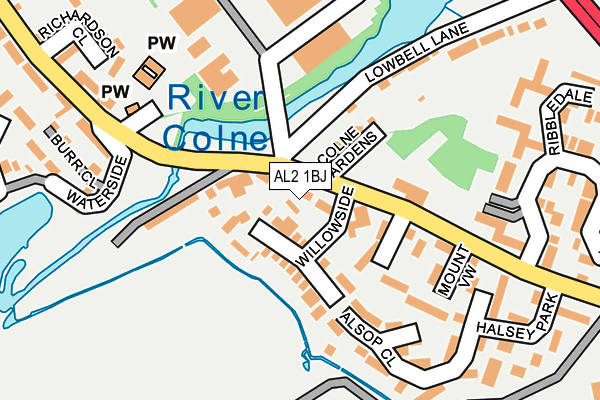
AL2 1BJ is located in the London Colney electoral ward, within the local authority district of St Albans and the English Parliamentary constituency of St Albans. The Sub Integrated Care Board (ICB) Location is NHS Hertfordshire and West Essex ICB - 06N and the police force is Hertfordshire. This postcode has been in use since January 2006.


GetTheData
Source: OS OpenMap – Local (Ordnance Survey)
Source: OS VectorMap District (Ordnance Survey)
Licence: Open Government Licence (requires attribution)
| Easting | 518348 |
| Northing | 203645 |
| Latitude | 51.719059 |
| Longitude | -0.288152 |
GetTheData
Source: Open Postcode Geo
Licence: Open Government Licence
| Country | England |
| Postcode District | AL2 |
➜ See where AL2 is on a map ➜ Where is London Colney? | |
GetTheData
Source: Land Registry Price Paid Data
Licence: Open Government Licence
Elevation or altitude of AL2 1BJ as distance above sea level:
| Metres | Feet | |
|---|---|---|
| Elevation | 70m | 230ft |
Elevation is measured from the approximate centre of the postcode, to the nearest point on an OS contour line from OS Terrain 50, which has contour spacing of ten vertical metres.
➜ How high above sea level am I? Find the elevation of your current position using your device's GPS.
GetTheData
Source: Open Postcode Elevation
Licence: Open Government Licence
| Ward | London Colney |
| Constituency | St Albans |
GetTheData
Source: ONS Postcode Database
Licence: Open Government Licence
| Willowside (Barnet Road) | London Colney | 27m |
| Willowside (Barnet Road) | London Colney | 68m |
| Thamesdale (Barnet Road) | London Colney | 197m |
| Thamesdale (Barnet Road) | London Colney | 212m |
| Colney Fields Retail Park (Private Road) | London Colney | 282m |
| Park Street Station | 3.7km |
| How Wood (Herts) Station | 3.9km |
| Radlett Station | 4.3km |
GetTheData
Source: NaPTAN
Licence: Open Government Licence
GetTheData
Source: ONS Postcode Database
Licence: Open Government Licence


➜ Get more ratings from the Food Standards Agency
GetTheData
Source: Food Standards Agency
Licence: FSA terms & conditions
| Last Collection | |||
|---|---|---|---|
| Location | Mon-Fri | Sat | Distance |
| Napsbury P.o | 17:30 | 12:00 | 131m |
| Thamesdale London Colney | 17:30 | 12:00 | 236m |
| Haseldine Road | 18:40 | 12:00 | 763m |
GetTheData
Source: Dracos
Licence: Creative Commons Attribution-ShareAlike
| Risk of AL2 1BJ flooding from rivers and sea | Very Low |
| ➜ AL2 1BJ flood map | |
GetTheData
Source: Open Flood Risk by Postcode
Licence: Open Government Licence
The below table lists the International Territorial Level (ITL) codes (formerly Nomenclature of Territorial Units for Statistics (NUTS) codes) and Local Administrative Units (LAU) codes for AL2 1BJ:
| ITL 1 Code | Name |
|---|---|
| TLH | East |
| ITL 2 Code | Name |
| TLH2 | Bedfordshire and Hertfordshire |
| ITL 3 Code | Name |
| TLH23 | Hertfordshire CC |
| LAU 1 Code | Name |
| E07000240 | St Albans |
GetTheData
Source: ONS Postcode Directory
Licence: Open Government Licence
The below table lists the Census Output Area (OA), Lower Layer Super Output Area (LSOA), and Middle Layer Super Output Area (MSOA) for AL2 1BJ:
| Code | Name | |
|---|---|---|
| OA | E00120381 | |
| LSOA | E01023704 | St Albans 018A |
| MSOA | E02004941 | St Albans 018 |
GetTheData
Source: ONS Postcode Directory
Licence: Open Government Licence
| AL2 1QU | Barnet Road | 53m |
| AL2 1BG | Barnet Road | 64m |
| AL2 1DP | Willowside | 72m |
| AL2 1BE | Colne Gardens | 74m |
| AL2 1QX | Waterside | 83m |
| AL2 1BS | Colnbrook Close | 90m |
| AL2 1DY | Armstrong Close | 100m |
| AL2 1QY | Summers Way | 126m |
| AL2 1AU | Barnet Road | 152m |
| AL2 1QZ | Waterside | 155m |
GetTheData
Source: Open Postcode Geo; Land Registry Price Paid Data
Licence: Open Government Licence