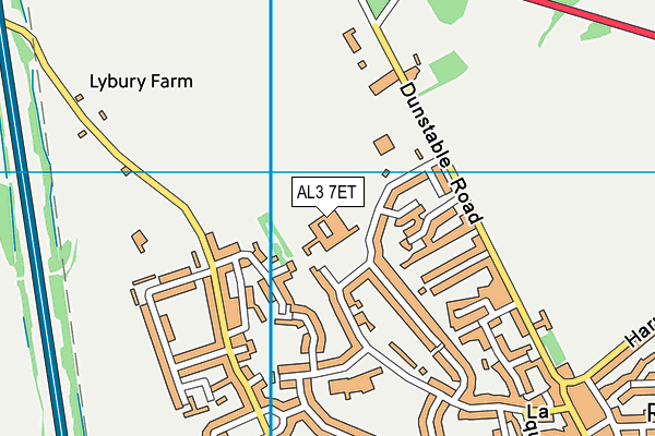
St Luke's School is located in Redbourn, St Albans and falls under the local authority of Hertfordshire. This mixed-sex school has 160 pupils, with a capacity of 175, aged from seven up to sixteen, and the type of establishment is foundation special school. The most recend Ofsted inspection was 8th June 2023 resulting in an good rating.
| Address | St Luke's School Crouch Hall Lane Redbourn St Albans Hertfordshire AL3 7ET |
| Website | http://www.stlukes.herts.sch.uk/ |
| Headteacher | Mr Stephen Hoult-Allen |
GetTheData
Source: Get Information About Schools
Licence: Open Government Licence
| Phase of Education | Not applicable |
| Type of Establishment | Foundation special school |
| Admissions Policy | Not applicable |
| Statutory Low Age | 7 |
| Statutory High Age | 16 |
| Boarders | No boarders |
| Official Sixth Form | Not applicable |
| Gender | Mixed |
| Religious Character | Does not apply |
| Diocese | Not applicable |
| Special Classes | Has Special Classes |
GetTheData
Source: Get Information About Schools
Licence: Open Government Licence
| Census Date | 19th January 2023 | |
| School Capacity | 175 | |
| Number of Pupils | 160 | 91% capacity |
| Number of Boys | 104 | 65% |
| Number of Girls | 56 | 35% |
| Free School Meals (%) | 43.10% |
GetTheData
Source: Get Information About Schools
Licence: Open Government Licence
| Street Address | Crouch Hall Lane |
| Locality | Redbourn |
| Town | St Albans |
| County | Hertfordshire |
| Postcode | AL3 7ET |
| ➜ More AL3 7ET open data | |
GetTheData
Source: Get Information About Schools
Licence: Open Government Licence

GetTheData
Source: OS VectorMap District (Ordnance Survey)
Licence: Open Government Licence (requires attribution)
| Ofsted Last Inspection | 8th June 2023 |
| Ofsted Rating | Good |
| Ofsted Special Measures | Not applicable |
GetTheData
Source: Get Information About Schools
Licence: Open Government Licence
| Establishment Name | St Luke's School |
| Establishment Number | 7012 |
| Unique Reference Number | 117671 |
| Local Authority | Hertfordshire |
| Local Authority Code | 919 |
| Previous Local Authority Code | 999 |
| Government Statistical Service Local Authority Code | E10000015 |
| Government Office Region | East of England |
| District | St Albans |
| District Code | E07000240 |
| Ward | Redbourn |
| Parliamentary Constituency | Hitchin and Harpenden |
| Urban/Rural Description | (England/Wales) Rural town and fringe |
| Middle Super Output Area | St Albans 006 |
| Lower Super Output Area | St Albans 006D |
GetTheData
Source: Get Information About Schools
Licence: Open Government Licence
| Establishment Status | Open |
| Last Changed Date | 10th January 2024 |
| Reason Establishment Opened | Not applicable |
| Reason Establishment Closed | Not applicable |
GetTheData
Source: Get Information About Schools
Licence: Open Government Licence
| Teenage Mothers | Not applicable |
| Child Care Facilities | Not applicable |
| Special Educational Needs (SEN) Provision in Primary Care Unit | Not applicable |
| Pupil Referral Unit (PRU) Provides for Educational and Behavioural Difficulties (EBD) | Not applicable |
| Pupil Referral Unit (PRU) Offers Tuition by Another Provider | Not applicable |
GetTheData
Source: Get Information About Schools
Licence: Open Government Licence
| Section 41 Approved | Not applicable |
| Special Educational Needs (SEN) Priority 1 | SpLD - Specific Learning Difficulty |
| Special Educational Needs (SEN) Priority 2 | VI - Visual Impairment |
| Special Educational Needs (SEN) Priority 3 | OTH - Other Difficulty/Disability |
GetTheData
Source: Get Information About Schools
Licence: Open Government Licence
| Trust flag | Not supported by a trust |
| School Sponsor flag | Not applicable |
GetTheData
Source: Get Information About Schools
Licence: Open Government Licence
| Federation flag | Not under a federation |
GetTheData
Source: Get Information About Schools
Licence: Open Government Licence
| UK Provider Reference Number | 10008515 |
| Further Education Type | Not applicable |
GetTheData
Source: Get Information About Schools
Licence: Open Government Licence
| Easting | 510132 |
| Northing | 212893 |
| Latitude | 51.80384 |
| Longitude | -0.40414 |
GetTheData
Source: Get Information About Schools
Licence: Open Government Licence
| School | Phase of Education | Distance |
|---|---|---|
| Redbourn Primary School Long Cutt, Redbourn, St Albans, AL3 7EX | Primary | 324m |
| Flamstead Village School Trowley Hill Road, Flamstead, 59 Trowley Hill Road, St. Albans, AL3 8DL | Primary | 2.7km |
| Roundwood Park School Roundwood Park, Harpenden, AL5 3AE | Secondary | 2.8km |
| Roundwood Primary School Roundwood Park, Harpenden, AL5 3AD | Primary | 2.9km |
| Wood End School Yeomans Avenue, Harpenden, AL5 3EF | Primary | 3km |
| St Hilda's School 28 Douglas Road, Harpenden, AL5 2ES | Not applicable | 3.2km |
| St Nicholas CofE VA Primary School Church Green, Harpenden, AL5 2TP | Primary | 3.5km |
| Brockswood Primary School Shenley Road, Woodhall Farm, Hemel Hempstead, HP2 7QH | Primary | 3.5km |
| Harpenden Academy 25 Vaughan Road, Harpenden, AL5 4EL | Primary | 3.7km |
| St Dominic Catholic Primary School St Dominic Catholic Primary School, Southdown Road, HARPENDEN, AL5 1PF | Primary | 3.8km |
GetTheData
Source: Get Information About Schools
Licence: Open Government Licence