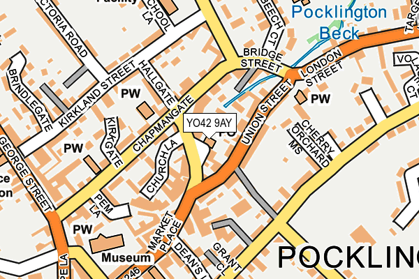
YO42 9AY is located in the Pocklington Provincial electoral ward, within the unitary authority of East Riding of Yorkshire and the English Parliamentary constituency of East Yorkshire. The Sub Integrated Care Board (ICB) Location is NHS Humber and North Yorkshire ICB - 03Q and the police force is Humberside. This postcode has been in use since February 2017.


GetTheData
Source: OS OpenMap – Local (Ordnance Survey)
Source: OS VectorMap District (Ordnance Survey)
Licence: Open Government Licence (requires attribution)
| Easting | 480380 |
| Northing | 449123 |
| Latitude | 53.932020 |
| Longitude | -0.777249 |
GetTheData
Source: Open Postcode Geo
Licence: Open Government Licence
| Country | England |
| Postcode District | YO42 |
| ➜ YO42 open data dashboard ➜ See where YO42 is on a map ➜ Where is Pocklington? | |
GetTheData
Source: Land Registry Price Paid Data
Licence: Open Government Licence
| Ward | Pocklington Provincial |
| Constituency | East Yorkshire |
GetTheData
Source: ONS Postcode Database
Licence: Open Government Licence
| January 2024 | Violence and sexual offences | On or near Volage Court | 302m |
| December 2023 | Anti-social behaviour | On or near Volage Court | 302m |
| December 2023 | Violence and sexual offences | On or near Volage Court | 302m |
| ➜ Get more crime data in our Crime section | |||
GetTheData
Source: data.police.uk
Licence: Open Government Licence
| Pocklington Chapmangate (Chapmangate) | Pocklington | 74m |
| Pocklington Chapmangate (Chapmangate) | Pocklington | 81m |
| Pocklington London Street (London Street) | Pocklington | 211m |
| Pocklington George Street (George Street) | Pocklington | 248m |
| Pocklington Junior School (The Mile) | Pocklington | 249m |
GetTheData
Source: NaPTAN
Licence: Open Government Licence
GetTheData
Source: ONS Postcode Database
Licence: Open Government Licence


➜ Get more ratings from the Food Standards Agency
GetTheData
Source: Food Standards Agency
Licence: FSA terms & conditions
| Last Collection | |||
|---|---|---|---|
| Location | Mon-Fri | Sat | Distance |
| Pocklington Post Office | 18:25 | 12:00 | 8m |
| Union Street Pocklington | 17:10 | 11:30 | 166m |
| Railway Street Pocklington | 18:25 | 12:00 | 306m |
GetTheData
Source: Dracos
Licence: Creative Commons Attribution-ShareAlike
| Facility | Distance |
|---|---|
| Pocklington Rufc (Feathers Field/Burnby Lane) Burnby Lane, Pocklington Grass Pitches | 259m |
| Francis Scaife Sports Centre Burnby Lane, Pocklington, York Sports Hall, Swimming Pool, Health and Fitness Gym, Squash Courts | 459m |
| Pocklington School West Green, Pocklington, York Artificial Grass Pitch, Grass Pitches, Sports Hall, Swimming Pool, Squash Courts, Outdoor Tennis Courts | 530m |
GetTheData
Source: Active Places
Licence: Open Government Licence
| School | Phase of Education | Distance |
|---|---|---|
| Pocklington Junior School 65 Kirkland Street, Pocklington, York, YO42 2BX | Primary | 231m |
| St Mary & St Joseph Catholic Primary School - a Catholic voluntary academy Maxwell Road, Pocklington, YO42 2HE | Primary | 251m |
| Pocklington Church of England Voluntary Controlled Infant School Maxwell Road, York, YO42 2HE | Primary | 311m |
GetTheData
Source: Edubase
Licence: Open Government Licence
| Risk of YO42 9AY flooding from rivers and sea | High |
| ➜ YO42 9AY flood map | |
GetTheData
Source: Open Flood Risk by Postcode
Licence: Open Government Licence
The below table lists the International Territorial Level (ITL) codes (formerly Nomenclature of Territorial Units for Statistics (NUTS) codes) and Local Administrative Units (LAU) codes for YO42 9AY:
| ITL 1 Code | Name |
|---|---|
| TLE | Yorkshire and The Humber |
| ITL 2 Code | Name |
| TLE1 | East Yorkshire and Northern Lincolnshire |
| ITL 3 Code | Name |
| TLE12 | East Riding of Yorkshire |
| LAU 1 Code | Name |
| E06000011 | East Riding of Yorkshire |
GetTheData
Source: ONS Postcode Directory
Licence: Open Government Licence
The below table lists the Census Output Area (OA), Lower Layer Super Output Area (LSOA), and Middle Layer Super Output Area (MSOA) for YO42 9AY:
| Code | Name | |
|---|---|---|
| OA | E00065881 | |
| LSOA | E01013056 | East Riding of Yorkshire 011E |
| MSOA | E02002694 | East Riding of Yorkshire 011 |
GetTheData
Source: ONS Postcode Directory
Licence: Open Government Licence
| YO42 2AB | Market Street | 34m |
| YO42 2ET | Betterton Court | 39m |
| YO42 2JJ | Union Street | 49m |
| YO42 2XL | Union Street | 53m |
| YO42 2NQ | Turton House | 58m |
| YO42 2XA | Burns Cottages | 62m |
| YO42 2AE | Market Street | 64m |
| YO42 2JL | Union Street | 68m |
| YO42 2BY | Church Lane | 70m |
| YO42 2BJ | Chapmangate | 71m |
GetTheData
Source: Open Postcode Geo; Land Registry Price Paid Data
Licence: Open Government Licence