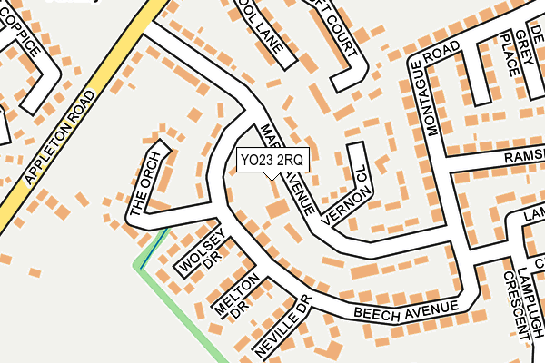
YO23 2RQ lies on Maple Avenue in Bishopthorpe, York. YO23 2RQ is located in the Bishopthorpe electoral ward, within the unitary authority of York and the English Parliamentary constituency of York Outer. The Sub Integrated Care Board (ICB) Location is NHS Humber and North Yorkshire ICB - 03Q and the police force is North Yorkshire. This postcode has been in use since June 1998.


GetTheData
Source: OS OpenMap – Local (Ordnance Survey)
Source: OS VectorMap District (Ordnance Survey)
Licence: Open Government Licence (requires attribution)
| Easting | 459259 |
| Northing | 447332 |
| Latitude | 53.918750 |
| Longitude | -1.099224 |
GetTheData
Source: Open Postcode Geo
Licence: Open Government Licence
| Street | Maple Avenue |
| Locality | Bishopthorpe |
| Town/City | York |
| Country | England |
| Postcode District | YO23 |
➜ See where YO23 is on a map ➜ Where is Bishopthorpe? | |
GetTheData
Source: Land Registry Price Paid Data
Licence: Open Government Licence
Elevation or altitude of YO23 2RQ as distance above sea level:
| Metres | Feet | |
|---|---|---|
| Elevation | 10m | 33ft |
Elevation is measured from the approximate centre of the postcode, to the nearest point on an OS contour line from OS Terrain 50, which has contour spacing of ten vertical metres.
➜ How high above sea level am I? Find the elevation of your current position using your device's GPS.
GetTheData
Source: Open Postcode Elevation
Licence: Open Government Licence
| Ward | Bishopthorpe |
| Constituency | York Outer |
GetTheData
Source: ONS Postcode Database
Licence: Open Government Licence
| Beech Avenue | Bishopthorpe | 101m |
| Beech Avenue (Maple Avenue) | Bishopthorpe | 108m |
| Ramsey Avenue (Montague Road) | Bishopthorpe | 179m |
| Maple Avenue | Bishopthorpe | 185m |
| Ramsey Avenue (Montague Road) | Bishopthorpe | 188m |
| York Station | 4.4km |
GetTheData
Source: NaPTAN
Licence: Open Government Licence
| Percentage of properties with Next Generation Access | 100.0% |
| Percentage of properties with Superfast Broadband | 100.0% |
| Percentage of properties with Ultrafast Broadband | 0.0% |
| Percentage of properties with Full Fibre Broadband | 0.0% |
Superfast Broadband is between 30Mbps and 300Mbps
Ultrafast Broadband is > 300Mbps
| Median download speed | 32.4Mbps |
| Average download speed | 27.3Mbps |
| Maximum download speed | 56.74Mbps |
| Median upload speed | 6.4Mbps |
| Average upload speed | 6.7Mbps |
| Maximum upload speed | 18.56Mbps |
| Percentage of properties unable to receive 2Mbps | 0.0% |
| Percentage of properties unable to receive 5Mbps | 0.0% |
| Percentage of properties unable to receive 10Mbps | 0.0% |
| Percentage of properties unable to receive 30Mbps | 0.0% |
GetTheData
Source: Ofcom
Licence: Ofcom Terms of Use (requires attribution)
Estimated total energy consumption in YO23 2RQ by fuel type, 2015.
| Consumption (kWh) | 329,649 |
|---|---|
| Meter count | 31 |
| Mean (kWh/meter) | 10,634 |
| Median (kWh/meter) | 10,422 |
| Consumption (kWh) | 132,260 |
|---|---|
| Meter count | 34 |
| Mean (kWh/meter) | 3,890 |
| Median (kWh/meter) | 2,489 |
GetTheData
Source: Postcode level gas estimates: 2015 (experimental)
Source: Postcode level electricity estimates: 2015 (experimental)
Licence: Open Government Licence
GetTheData
Source: ONS Postcode Database
Licence: Open Government Licence


➜ Get more ratings from the Food Standards Agency
GetTheData
Source: Food Standards Agency
Licence: FSA terms & conditions
| Last Collection | |||
|---|---|---|---|
| Location | Mon-Fri | Sat | Distance |
| 72 Maple Avenue Bishopthorpe | 17:30 | 10:30 | 182m |
| Bishopthorpe Post Office | 17:30 | 12:00 | 347m |
| Acaster Lane | 18:00 | 10:15 | 422m |
GetTheData
Source: Dracos
Licence: Creative Commons Attribution-ShareAlike
The below table lists the International Territorial Level (ITL) codes (formerly Nomenclature of Territorial Units for Statistics (NUTS) codes) and Local Administrative Units (LAU) codes for YO23 2RQ:
| ITL 1 Code | Name |
|---|---|
| TLE | Yorkshire and The Humber |
| ITL 2 Code | Name |
| TLE2 | North Yorkshire |
| ITL 3 Code | Name |
| TLE21 | York |
| LAU 1 Code | Name |
| E06000014 | York |
GetTheData
Source: ONS Postcode Directory
Licence: Open Government Licence
The below table lists the Census Output Area (OA), Lower Layer Super Output Area (LSOA), and Middle Layer Super Output Area (MSOA) for YO23 2RQ:
| Code | Name | |
|---|---|---|
| OA | E00067328 | |
| LSOA | E01013341 | York 024B |
| MSOA | E02002795 | York 024 |
GetTheData
Source: ONS Postcode Directory
Licence: Open Government Licence
| YO23 2RG | Maple Avenue | 68m |
| YO23 2RP | Wolsey Drive | 118m |
| YO23 2RL | Beech Avenue | 131m |
| YO23 2RW | Melton Drive | 142m |
| YO23 2RX | The Orchard | 152m |
| YO23 2RU | Croft Court | 156m |
| YO23 2RJ | Beech Avenue | 160m |
| YO23 2RN | Neville Drive | 166m |
| YO23 2RE | School Lane | 182m |
| YO23 2SP | Montague Road | 199m |
GetTheData
Source: Open Postcode Geo; Land Registry Price Paid Data
Licence: Open Government Licence