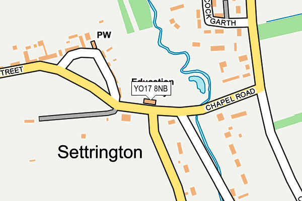
YO17 8NB lies on Chapel Road in Settrington, Malton. YO17 8NB is located in the Sheriff Hutton & Derwent electoral ward, within the unitary authority of North Yorkshire and the English Parliamentary constituency of Thirsk and Malton. The Sub Integrated Care Board (ICB) Location is NHS Humber and North Yorkshire ICB - 42D and the police force is North Yorkshire. This postcode has been in use since April 2005.


GetTheData
Source: OS OpenMap – Local (Ordnance Survey)
Source: OS VectorMap District (Ordnance Survey)
Licence: Open Government Licence (requires attribution)
| Easting | 483375 |
| Northing | 470728 |
| Latitude | 54.125658 |
| Longitude | -0.725716 |
GetTheData
Source: Open Postcode Geo
Licence: Open Government Licence
| Street | Chapel Road |
| Locality | Settrington |
| Town/City | Malton |
| Country | England |
| Postcode District | YO17 |
➜ See where YO17 is on a map ➜ Where is Settrington? | |
GetTheData
Source: Land Registry Price Paid Data
Licence: Open Government Licence
Elevation or altitude of YO17 8NB as distance above sea level:
| Metres | Feet | |
|---|---|---|
| Elevation | 30m | 98ft |
Elevation is measured from the approximate centre of the postcode, to the nearest point on an OS contour line from OS Terrain 50, which has contour spacing of ten vertical metres.
➜ How high above sea level am I? Find the elevation of your current position using your device's GPS.
GetTheData
Source: Open Postcode Elevation
Licence: Open Government Licence
| Ward | Sheriff Hutton & Derwent |
| Constituency | Thirsk And Malton |
GetTheData
Source: ONS Postcode Database
Licence: Open Government Licence
| Primary School (Chapel Road) | Settrington | 18m |
| Back Lane (Chapel Road) | Settrington | 29m |
| Chapel Road (Back Lane) | Settrington | 59m |
| Sports Field (Chapel Road) | Settrington | 61m |
| Quinns Stables (Town Street) | Settrington | 313m |
| Malton Station | 4.7km |
GetTheData
Source: NaPTAN
Licence: Open Government Licence
| Percentage of properties with Next Generation Access | 69.2% |
| Percentage of properties with Superfast Broadband | 69.2% |
| Percentage of properties with Ultrafast Broadband | 0.0% |
| Percentage of properties with Full Fibre Broadband | 0.0% |
Superfast Broadband is between 30Mbps and 300Mbps
Ultrafast Broadband is > 300Mbps
| Percentage of properties unable to receive 2Mbps | 0.0% |
| Percentage of properties unable to receive 5Mbps | 23.1% |
| Percentage of properties unable to receive 10Mbps | 30.8% |
| Percentage of properties unable to receive 30Mbps | 30.8% |
GetTheData
Source: Ofcom
Licence: Ofcom Terms of Use (requires attribution)
GetTheData
Source: ONS Postcode Database
Licence: Open Government Licence

➜ Get more ratings from the Food Standards Agency
GetTheData
Source: Food Standards Agency
Licence: FSA terms & conditions
| Last Collection | |||
|---|---|---|---|
| Location | Mon-Fri | Sat | Distance |
| Settrington | 17:15 | 12:30 | 415m |
| Drake Cottage Scagglethorpe | 17:30 | 10:10 | 1,757m |
| The Old Barn House Newstead | 17:15 | 12:45 | 2,467m |
GetTheData
Source: Dracos
Licence: Creative Commons Attribution-ShareAlike
The below table lists the International Territorial Level (ITL) codes (formerly Nomenclature of Territorial Units for Statistics (NUTS) codes) and Local Administrative Units (LAU) codes for YO17 8NB:
| ITL 1 Code | Name |
|---|---|
| TLE | Yorkshire and The Humber |
| ITL 2 Code | Name |
| TLE2 | North Yorkshire |
| ITL 3 Code | Name |
| TLE22 | North Yorkshire CC |
| LAU 1 Code | Name |
| E07000167 | Ryedale |
GetTheData
Source: ONS Postcode Directory
Licence: Open Government Licence
The below table lists the Census Output Area (OA), Lower Layer Super Output Area (LSOA), and Middle Layer Super Output Area (MSOA) for YO17 8NB:
| Code | Name | |
|---|---|---|
| OA | E00141476 | |
| LSOA | E01027779 | Ryedale 004A |
| MSOA | E02005791 | Ryedale 004 |
GetTheData
Source: ONS Postcode Directory
Licence: Open Government Licence
| YO17 8NS | Cock Garth | 220m |
| YO17 8NP | 271m | |
| YO17 8NR | Town Street | 313m |
| YO17 8DT | Main Street | 1748m |
| YO17 8DY | 1946m | |
| YO17 8ED | 1980m | |
| YO17 8DX | Charlton Place | 1996m |
| YO17 8DU | 2004m | |
| YO17 8DZ | 2072m | |
| YO17 8EE | Scarborough Road | 2187m |
GetTheData
Source: Open Postcode Geo; Land Registry Price Paid Data
Licence: Open Government Licence