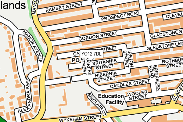
YO12 7DL lies on Fairfax Street in Scarborough. YO12 7DL is located in the Northstead electoral ward, within the unitary authority of North Yorkshire and the English Parliamentary constituency of Scarborough and Whitby. The Sub Integrated Care Board (ICB) Location is NHS Humber and North Yorkshire ICB - 42D and the police force is North Yorkshire. This postcode has been in use since January 1980.


GetTheData
Source: OS OpenMap – Local (Ordnance Survey)
Source: OS VectorMap District (Ordnance Survey)
Licence: Open Government Licence (requires attribution)
| Easting | 503199 |
| Northing | 488432 |
| Latitude | 54.281118 |
| Longitude | -0.416420 |
GetTheData
Source: Open Postcode Geo
Licence: Open Government Licence
| Street | Fairfax Street |
| Town/City | Scarborough |
| Country | England |
| Postcode District | YO12 |
➜ See where YO12 is on a map ➜ Where is Scarborough? | |
GetTheData
Source: Land Registry Price Paid Data
Licence: Open Government Licence
Elevation or altitude of YO12 7DL as distance above sea level:
| Metres | Feet | |
|---|---|---|
| Elevation | 50m | 164ft |
Elevation is measured from the approximate centre of the postcode, to the nearest point on an OS contour line from OS Terrain 50, which has contour spacing of ten vertical metres.
➜ How high above sea level am I? Find the elevation of your current position using your device's GPS.
GetTheData
Source: Open Postcode Elevation
Licence: Open Government Licence
| Ward | Northstead |
| Constituency | Scarborough And Whitby |
GetTheData
Source: ONS Postcode Database
Licence: Open Government Licence
| Manor Road End (Prospect Road) | Barrowcliffe | 153m |
| Raleigh Street (Prospect Road) | Northstead | 172m |
| Manor Road End (Prospect Road) | Barrowcliffe | 174m |
| Raleigh Street (Prospect Road) | Peasholm Park | 213m |
| Harley Close (A171) | Falsgrave | 355m |
| Scarborough Station | 0.7km |
| Seamer Station | 4.5km |
GetTheData
Source: NaPTAN
Licence: Open Government Licence
| Percentage of properties with Next Generation Access | 100.0% |
| Percentage of properties with Superfast Broadband | 100.0% |
| Percentage of properties with Ultrafast Broadband | 0.0% |
| Percentage of properties with Full Fibre Broadband | 0.0% |
Superfast Broadband is between 30Mbps and 300Mbps
Ultrafast Broadband is > 300Mbps
| Median download speed | 20.1Mbps |
| Average download speed | 30.0Mbps |
| Maximum download speed | 65.91Mbps |
| Median upload speed | 1.2Mbps |
| Average upload speed | 6.0Mbps |
| Maximum upload speed | 20.00Mbps |
| Percentage of properties unable to receive 2Mbps | 0.0% |
| Percentage of properties unable to receive 5Mbps | 0.0% |
| Percentage of properties unable to receive 10Mbps | 0.0% |
| Percentage of properties unable to receive 30Mbps | 0.0% |
GetTheData
Source: Ofcom
Licence: Ofcom Terms of Use (requires attribution)
Estimated total energy consumption in YO12 7DL by fuel type, 2015.
| Consumption (kWh) | 315,858 |
|---|---|
| Meter count | 24 |
| Mean (kWh/meter) | 13,161 |
| Median (kWh/meter) | 11,666 |
| Consumption (kWh) | 72,481 |
|---|---|
| Meter count | 23 |
| Mean (kWh/meter) | 3,151 |
| Median (kWh/meter) | 2,813 |
GetTheData
Source: Postcode level gas estimates: 2015 (experimental)
Source: Postcode level electricity estimates: 2015 (experimental)
Licence: Open Government Licence
GetTheData
Source: ONS Postcode Database
Licence: Open Government Licence


➜ Get more ratings from the Food Standards Agency
GetTheData
Source: Food Standards Agency
Licence: FSA terms & conditions
| Last Collection | |||
|---|---|---|---|
| Location | Mon-Fri | Sat | Distance |
| 2 Woodlands Ravine Scar/Ogh | 18:00 | 12:20 | 374m |
| Victoria Road Post Office | 17:30 | 12:15 | 538m |
| 2 Highfieldscarborough | 16:20 | 11:35 | 628m |
GetTheData
Source: Dracos
Licence: Creative Commons Attribution-ShareAlike
The below table lists the International Territorial Level (ITL) codes (formerly Nomenclature of Territorial Units for Statistics (NUTS) codes) and Local Administrative Units (LAU) codes for YO12 7DL:
| ITL 1 Code | Name |
|---|---|
| TLE | Yorkshire and The Humber |
| ITL 2 Code | Name |
| TLE2 | North Yorkshire |
| ITL 3 Code | Name |
| TLE22 | North Yorkshire CC |
| LAU 1 Code | Name |
| E07000168 | Scarborough |
GetTheData
Source: ONS Postcode Directory
Licence: Open Government Licence
The below table lists the Census Output Area (OA), Lower Layer Super Output Area (LSOA), and Middle Layer Super Output Area (MSOA) for YO12 7DL:
| Code | Name | |
|---|---|---|
| OA | E00141669 | |
| LSOA | E01027811 | Scarborough 008B |
| MSOA | E02005802 | Scarborough 008 |
GetTheData
Source: ONS Postcode Directory
Licence: Open Government Licence
| YO12 7DN | Britannia Street | 25m |
| YO12 7DH | Hibernia Street | 50m |
| YO12 7DW | Caledonia Street | 72m |
| YO12 7RX | Gordon Street | 74m |
| YO12 7DP | Caledonia Street | 78m |
| YO12 7RU | Gordon Street | 98m |
| YO12 7DR | Ireton Street | 103m |
| YO12 7DQ | Candler Street | 115m |
| YO12 7LD | Prospect Road | 123m |
| YO12 7DJ | Hibernia Street | 126m |
GetTheData
Source: Open Postcode Geo; Land Registry Price Paid Data
Licence: Open Government Licence