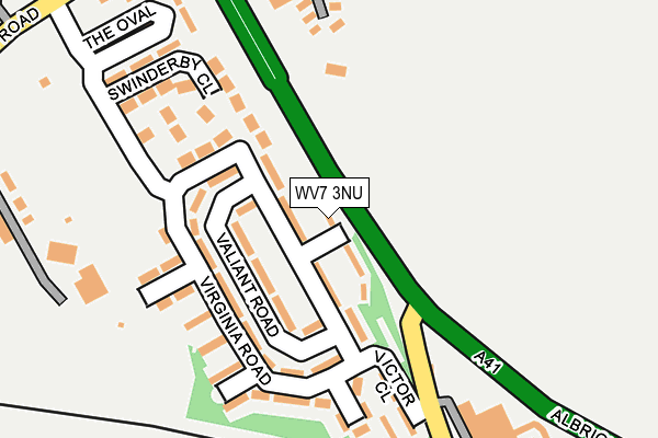
WV7 3NU is located in the Shifnal South and Cosford electoral ward, within the unitary authority of Shropshire and the English Parliamentary constituency of The Wrekin. The Sub Integrated Care Board (ICB) Location is NHS Shropshire, Telford and Wrekin ICB - M2L0M and the police force is West Mercia. This postcode has been in use since January 1980.


GetTheData
Source: OS OpenMap – Local (Ordnance Survey)
Source: OS VectorMap District (Ordnance Survey)
Licence: Open Government Licence (requires attribution)
| Easting | 380391 |
| Northing | 305411 |
| Latitude | 52.646077 |
| Longitude | -2.291253 |
GetTheData
Source: Open Postcode Geo
Licence: Open Government Licence
| Country | England |
| Postcode District | WV7 |
➜ See where WV7 is on a map | |
GetTheData
Source: Land Registry Price Paid Data
Licence: Open Government Licence
Elevation or altitude of WV7 3NU as distance above sea level:
| Metres | Feet | |
|---|---|---|
| Elevation | 90m | 295ft |
Elevation is measured from the approximate centre of the postcode, to the nearest point on an OS contour line from OS Terrain 50, which has contour spacing of ten vertical metres.
➜ How high above sea level am I? Find the elevation of your current position using your device's GPS.
GetTheData
Source: Open Postcode Elevation
Licence: Open Government Licence
| Ward | Shifnal South And Cosford |
| Constituency | The Wrekin |
GetTheData
Source: ONS Postcode Database
Licence: Open Government Licence
| Garage (Newport Road) | Cosford | 216m |
| Garage (Newport Road) | Cosford | 246m |
| Long Lane Jct (Newport Road) | Cosford | 628m |
| Long Lane Jct (Newport Road) | Cosford | 638m |
| Fire Station (Newport Road) | Albrighton | 735m |
| Cosford Station | 0.6km |
| Albrighton Station | 1.8km |
GetTheData
Source: NaPTAN
Licence: Open Government Licence
| Percentage of properties with Next Generation Access | 100.0% |
| Percentage of properties with Superfast Broadband | 100.0% |
| Percentage of properties with Ultrafast Broadband | 0.0% |
| Percentage of properties with Full Fibre Broadband | 0.0% |
Superfast Broadband is between 30Mbps and 300Mbps
Ultrafast Broadband is > 300Mbps
| Median download speed | 26.8Mbps |
| Average download speed | 21.7Mbps |
| Maximum download speed | 39.06Mbps |
| Median upload speed | 5.9Mbps |
| Average upload speed | 5.1Mbps |
| Maximum upload speed | 9.57Mbps |
| Percentage of properties unable to receive 2Mbps | 0.0% |
| Percentage of properties unable to receive 5Mbps | 0.0% |
| Percentage of properties unable to receive 10Mbps | 0.0% |
| Percentage of properties unable to receive 30Mbps | 0.0% |
GetTheData
Source: Ofcom
Licence: Ofcom Terms of Use (requires attribution)
Estimated total energy consumption in WV7 3NU by fuel type, 2015.
| Consumption (kWh) | 99,430 |
|---|---|
| Meter count | 12 |
| Mean (kWh/meter) | 8,286 |
| Median (kWh/meter) | 7,281 |
| Consumption (kWh) | 40,457 |
|---|---|
| Meter count | 10 |
| Mean (kWh/meter) | 4,046 |
| Median (kWh/meter) | 3,557 |
GetTheData
Source: Postcode level gas estimates: 2015 (experimental)
Source: Postcode level electricity estimates: 2015 (experimental)
Licence: Open Government Licence
GetTheData
Source: ONS Postcode Database
Licence: Open Government Licence


➜ Get more ratings from the Food Standards Agency
GetTheData
Source: Food Standards Agency
Licence: FSA terms & conditions
| Last Collection | |||
|---|---|---|---|
| Location | Mon-Fri | Sat | Distance |
| Albrighton Post Office | 17:30 | 12:00 | 1,494m |
| Tong | 10:15 | 10:15 | 2,093m |
| Tong Norton | 11:30 | 09:15 | 2,861m |
GetTheData
Source: Dracos
Licence: Creative Commons Attribution-ShareAlike
The below table lists the International Territorial Level (ITL) codes (formerly Nomenclature of Territorial Units for Statistics (NUTS) codes) and Local Administrative Units (LAU) codes for WV7 3NU:
| ITL 1 Code | Name |
|---|---|
| TLG | West Midlands (England) |
| ITL 2 Code | Name |
| TLG2 | Shropshire and Staffordshire |
| ITL 3 Code | Name |
| TLG22 | Shropshire |
| LAU 1 Code | Name |
| E06000051 | Shropshire |
GetTheData
Source: ONS Postcode Directory
Licence: Open Government Licence
The below table lists the Census Output Area (OA), Lower Layer Super Output Area (LSOA), and Middle Layer Super Output Area (MSOA) for WV7 3NU:
| Code | Name | |
|---|---|---|
| OA | E00174579 | |
| LSOA | E01028844 | Shropshire 027C |
| MSOA | E02006009 | Shropshire 027 |
GetTheData
Source: ONS Postcode Directory
Licence: Open Government Licence
| WV7 3ET | Newport Road | 358m |
| WV7 3NB | Sydnal Lane | 387m |
| WV7 3ES | Sandy Lane | 460m |
| WV7 3EP | Rectory Road | 784m |
| WV7 3EW | Newport Road | 811m |
| TF11 8PL | 867m | |
| WV7 3EN | Grange Park | 895m |
| WV7 3HS | Loak Road | 896m |
| WV7 3HW | St Cuthberts Crescent | 907m |
| WV7 3HR | Loak Road | 963m |
GetTheData
Source: Open Postcode Geo; Land Registry Price Paid Data
Licence: Open Government Licence