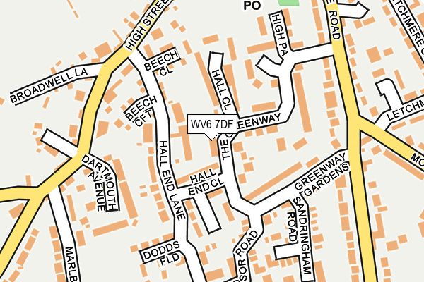
WV6 7DF lies on The Greenway in Pattingham, Wolverhampton. WV6 7DF is located in the Pattingham, Trysull, Bobbington & Lower Penn electoral ward, within the local authority district of South Staffordshire and the English Parliamentary constituency of South Staffordshire. The Sub Integrated Care Board (ICB) Location is NHS Staffordshire and Stoke-on-Trent ICB - 05Q and the police force is Staffordshire. This postcode has been in use since January 1980.


GetTheData
Source: OS OpenMap – Local (Ordnance Survey)
Source: OS VectorMap District (Ordnance Survey)
Licence: Open Government Licence (requires attribution)
| Easting | 382154 |
| Northing | 298828 |
| Latitude | 52.586960 |
| Longitude | -2.264838 |
GetTheData
Source: Open Postcode Geo
Licence: Open Government Licence
| Street | The Greenway |
| Locality | Pattingham |
| Town/City | Wolverhampton |
| Country | England |
| Postcode District | WV6 |
➜ See where WV6 is on a map ➜ Where is Pattingham? | |
GetTheData
Source: Land Registry Price Paid Data
Licence: Open Government Licence
Elevation or altitude of WV6 7DF as distance above sea level:
| Metres | Feet | |
|---|---|---|
| Elevation | 110m | 361ft |
Elevation is measured from the approximate centre of the postcode, to the nearest point on an OS contour line from OS Terrain 50, which has contour spacing of ten vertical metres.
➜ How high above sea level am I? Find the elevation of your current position using your device's GPS.
GetTheData
Source: Open Postcode Elevation
Licence: Open Government Licence
| Ward | Pattingham, Trysull, Bobbington & Lower Penn |
| Constituency | South Staffordshire |
GetTheData
Source: ONS Postcode Database
Licence: Open Government Licence
| Shops (High Street) | Pattingham | 243m |
| Shops (High Street) | Pattingham | 293m |
| Newgate (Wolverhampton Road) | Pattingham | 392m |
| Newgate (Wolverhampton Road) | Pattingham | 394m |
| Codsall Station | 6.2km |
GetTheData
Source: NaPTAN
Licence: Open Government Licence
| Percentage of properties with Next Generation Access | 100.0% |
| Percentage of properties with Superfast Broadband | 100.0% |
| Percentage of properties with Ultrafast Broadband | 0.0% |
| Percentage of properties with Full Fibre Broadband | 0.0% |
Superfast Broadband is between 30Mbps and 300Mbps
Ultrafast Broadband is > 300Mbps
| Percentage of properties unable to receive 2Mbps | 0.0% |
| Percentage of properties unable to receive 5Mbps | 0.0% |
| Percentage of properties unable to receive 10Mbps | 0.0% |
| Percentage of properties unable to receive 30Mbps | 0.0% |
GetTheData
Source: Ofcom
Licence: Ofcom Terms of Use (requires attribution)
GetTheData
Source: ONS Postcode Database
Licence: Open Government Licence


➜ Get more ratings from the Food Standards Agency
GetTheData
Source: Food Standards Agency
Licence: FSA terms & conditions
| Last Collection | |||
|---|---|---|---|
| Location | Mon-Fri | Sat | Distance |
| Dartmouth Avenue | 16:45 | 11:45 | 178m |
| Clive Road | 16:45 | 11:45 | 212m |
| Pattingham Post Office | 16:45 | 11:45 | 230m |
GetTheData
Source: Dracos
Licence: Creative Commons Attribution-ShareAlike
The below table lists the International Territorial Level (ITL) codes (formerly Nomenclature of Territorial Units for Statistics (NUTS) codes) and Local Administrative Units (LAU) codes for WV6 7DF:
| ITL 1 Code | Name |
|---|---|
| TLG | West Midlands (England) |
| ITL 2 Code | Name |
| TLG2 | Shropshire and Staffordshire |
| ITL 3 Code | Name |
| TLG24 | Staffordshire CC |
| LAU 1 Code | Name |
| E07000196 | South Staffordshire |
GetTheData
Source: ONS Postcode Directory
Licence: Open Government Licence
The below table lists the Census Output Area (OA), Lower Layer Super Output Area (LSOA), and Middle Layer Super Output Area (MSOA) for WV6 7DF:
| Code | Name | |
|---|---|---|
| OA | E00151092 | |
| LSOA | E01029654 | South Staffordshire 010A |
| MSOA | E02006183 | South Staffordshire 010 |
GetTheData
Source: ONS Postcode Directory
Licence: Open Government Licence
| WV6 7DG | Hall End Close | 49m |
| WV6 7DA | The Greenway | 81m |
| WV6 7DD | The Greenway | 83m |
| WV6 7BL | Hall End Lane | 94m |
| WV6 7DE | Hall Close | 101m |
| WV6 7DQ | The Greenway | 102m |
| WV6 7DH | Greenway Gardens | 109m |
| WV6 7BA | Beech Close | 120m |
| WV6 7BZ | The Square | 120m |
| WV6 7BW | Beechcroft | 134m |
GetTheData
Source: Open Postcode Geo; Land Registry Price Paid Data
Licence: Open Government Licence