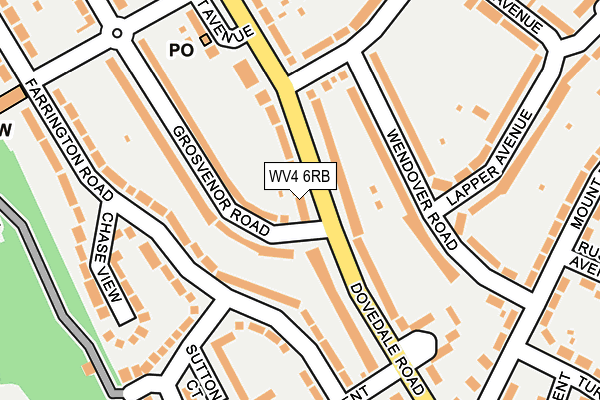
WV4 6RB lies on Dovedale Road in Wolverhampton. WV4 6RB is located in the Ettingshall South & Spring Vale electoral ward, within the metropolitan district of Wolverhampton and the English Parliamentary constituency of Wolverhampton South East. The Sub Integrated Care Board (ICB) Location is NHS Black Country ICB - D2P2L and the police force is West Midlands. This postcode has been in use since January 1980.


GetTheData
Source: OS OpenMap – Local (Ordnance Survey)
Source: OS VectorMap District (Ordnance Survey)
Licence: Open Government Licence (requires attribution)
| Easting | 392437 |
| Northing | 294871 |
| Latitude | 52.551630 |
| Longitude | -2.112971 |
GetTheData
Source: Open Postcode Geo
Licence: Open Government Licence
| Street | Dovedale Road |
| Town/City | Wolverhampton |
| Country | England |
| Postcode District | WV4 |
➜ See where WV4 is on a map ➜ Where is Wolverhampton? | |
GetTheData
Source: Land Registry Price Paid Data
Licence: Open Government Licence
Elevation or altitude of WV4 6RB as distance above sea level:
| Metres | Feet | |
|---|---|---|
| Elevation | 180m | 591ft |
Elevation is measured from the approximate centre of the postcode, to the nearest point on an OS contour line from OS Terrain 50, which has contour spacing of ten vertical metres.
➜ How high above sea level am I? Find the elevation of your current position using your device's GPS.
GetTheData
Source: Open Postcode Elevation
Licence: Open Government Licence
| Ward | Ettingshall South & Spring Vale |
| Constituency | Wolverhampton South East |
GetTheData
Source: ONS Postcode Database
Licence: Open Government Licence
| Grosvenor Rd (Dovedale Rd) | Woodcross | 18m |
| Grosvenor Rd (Dovedale Rd) | Woodcross | 41m |
| Camberley Crescent (Dovedale Rd) | Woodcross | 213m |
| Dovedale Rd (Laburnum Rd) | Lanesfield | 245m |
| Camberley Crescent (Dovedale Rd) | Woodcross | 257m |
| Coseley Station | 2km |
| Tipton Station | 4km |
| Wolverhampton Station | 4.1km |
GetTheData
Source: NaPTAN
Licence: Open Government Licence
| Percentage of properties with Next Generation Access | 100.0% |
| Percentage of properties with Superfast Broadband | 100.0% |
| Percentage of properties with Ultrafast Broadband | 94.7% |
| Percentage of properties with Full Fibre Broadband | 0.0% |
Superfast Broadband is between 30Mbps and 300Mbps
Ultrafast Broadband is > 300Mbps
| Median download speed | 46.9Mbps |
| Average download speed | 62.7Mbps |
| Maximum download speed | 200.00Mbps |
| Median upload speed | 9.8Mbps |
| Average upload speed | 8.3Mbps |
| Maximum upload speed | 20.00Mbps |
| Percentage of properties unable to receive 2Mbps | 0.0% |
| Percentage of properties unable to receive 5Mbps | 0.0% |
| Percentage of properties unable to receive 10Mbps | 0.0% |
| Percentage of properties unable to receive 30Mbps | 0.0% |
GetTheData
Source: Ofcom
Licence: Ofcom Terms of Use (requires attribution)
Estimated total energy consumption in WV4 6RB by fuel type, 2015.
| Consumption (kWh) | 629,483 |
|---|---|
| Meter count | 40 |
| Mean (kWh/meter) | 15,737 |
| Median (kWh/meter) | 14,889 |
| Consumption (kWh) | 106,261 |
|---|---|
| Meter count | 32 |
| Mean (kWh/meter) | 3,321 |
| Median (kWh/meter) | 2,897 |
GetTheData
Source: Postcode level gas estimates: 2015 (experimental)
Source: Postcode level electricity estimates: 2015 (experimental)
Licence: Open Government Licence
GetTheData
Source: ONS Postcode Database
Licence: Open Government Licence


➜ Get more ratings from the Food Standards Agency
GetTheData
Source: Food Standards Agency
Licence: FSA terms & conditions
| Last Collection | |||
|---|---|---|---|
| Location | Mon-Fri | Sat | Distance |
| Bath Street | 17:30 | 11:00 | 629m |
| Beacon Rise | 17:30 | 11:00 | 728m |
| Bilston Street | 17:30 | 11:00 | 924m |
GetTheData
Source: Dracos
Licence: Creative Commons Attribution-ShareAlike
The below table lists the International Territorial Level (ITL) codes (formerly Nomenclature of Territorial Units for Statistics (NUTS) codes) and Local Administrative Units (LAU) codes for WV4 6RB:
| ITL 1 Code | Name |
|---|---|
| TLG | West Midlands (England) |
| ITL 2 Code | Name |
| TLG3 | West Midlands |
| ITL 3 Code | Name |
| TLG39 | Wolverhampton |
| LAU 1 Code | Name |
| E08000031 | Wolverhampton |
GetTheData
Source: ONS Postcode Directory
Licence: Open Government Licence
The below table lists the Census Output Area (OA), Lower Layer Super Output Area (LSOA), and Middle Layer Super Output Area (MSOA) for WV4 6RB:
| Code | Name | |
|---|---|---|
| OA | E00053190 | |
| LSOA | E01010537 | Wolverhampton 032D |
| MSOA | E02002180 | Wolverhampton 032 |
GetTheData
Source: ONS Postcode Directory
Licence: Open Government Licence
| WV4 6RE | Dovedale Road | 57m |
| WV4 6NA | Wendover Road | 110m |
| WV4 6QL | Farrington Road | 115m |
| WV4 6QU | Grosvenor Road | 115m |
| WV4 6QT | Grosvenor Road | 122m |
| WV4 6NB | Wendover Road | 133m |
| WV4 6PW | Ward Grove | 191m |
| WV4 6ND | Wendover Road | 191m |
| WV4 6QN | Chase View | 196m |
| WV4 6QW | Sutton Court | 198m |
GetTheData
Source: Open Postcode Geo; Land Registry Price Paid Data
Licence: Open Government Licence