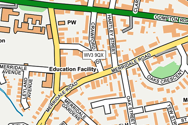
WV3 9QX lies on Crawford Road in Wolverhampton. WV3 9QX is located in the Park electoral ward, within the metropolitan district of Wolverhampton and the English Parliamentary constituency of Wolverhampton South West. The Sub Integrated Care Board (ICB) Location is NHS Black Country ICB - D2P2L and the police force is West Midlands. This postcode has been in use since January 1980.


GetTheData
Source: OS OpenMap – Local (Ordnance Survey)
Source: OS VectorMap District (Ordnance Survey)
Licence: Open Government Licence (requires attribution)
| Easting | 390173 |
| Northing | 298522 |
| Latitude | 52.584415 |
| Longitude | -2.146470 |
GetTheData
Source: Open Postcode Geo
Licence: Open Government Licence
| Street | Crawford Road |
| Town/City | Wolverhampton |
| Country | England |
| Postcode District | WV3 |
➜ See where WV3 is on a map ➜ Where is Wolverhampton? | |
GetTheData
Source: Land Registry Price Paid Data
Licence: Open Government Licence
Elevation or altitude of WV3 9QX as distance above sea level:
| Metres | Feet | |
|---|---|---|
| Elevation | 130m | 427ft |
Elevation is measured from the approximate centre of the postcode, to the nearest point on an OS contour line from OS Terrain 50, which has contour spacing of ten vertical metres.
➜ How high above sea level am I? Find the elevation of your current position using your device's GPS.
GetTheData
Source: Open Postcode Elevation
Licence: Open Government Licence
| Ward | Park |
| Constituency | Wolverhampton South West |
GetTheData
Source: ONS Postcode Database
Licence: Open Government Licence
| Crawford Rd (Merridale Rd) | Merridale | 61m |
| Merridale Lane (Merridale Rd) | Merridale | 113m |
| Crawford Rd (Merridale Rd) | Merridale | 141m |
| Hartley St (Compton Rd) | Merridale | 171m |
| Hartley St (Compton Rd) | Merridale | 181m |
| Wolverhampton Station | 1.9km |
| Bilbrook Station | 5.1km |
| Coseley Station | 6km |
GetTheData
Source: NaPTAN
Licence: Open Government Licence
| Percentage of properties with Next Generation Access | 100.0% |
| Percentage of properties with Superfast Broadband | 100.0% |
| Percentage of properties with Ultrafast Broadband | 100.0% |
| Percentage of properties with Full Fibre Broadband | 0.0% |
Superfast Broadband is between 30Mbps and 300Mbps
Ultrafast Broadband is > 300Mbps
| Percentage of properties unable to receive 2Mbps | 0.0% |
| Percentage of properties unable to receive 5Mbps | 0.0% |
| Percentage of properties unable to receive 10Mbps | 0.0% |
| Percentage of properties unable to receive 30Mbps | 0.0% |
GetTheData
Source: Ofcom
Licence: Ofcom Terms of Use (requires attribution)
GetTheData
Source: ONS Postcode Database
Licence: Open Government Licence


➜ Get more ratings from the Food Standards Agency
GetTheData
Source: Food Standards Agency
Licence: FSA terms & conditions
| Last Collection | |||
|---|---|---|---|
| Location | Mon-Fri | Sat | Distance |
| Oak Street | 17:30 | 12:00 | 100m |
| Compton Road | 16:00 | 12:00 | 210m |
| Connaught Road | 18:30 | 12:30 | 354m |
GetTheData
Source: Dracos
Licence: Creative Commons Attribution-ShareAlike
The below table lists the International Territorial Level (ITL) codes (formerly Nomenclature of Territorial Units for Statistics (NUTS) codes) and Local Administrative Units (LAU) codes for WV3 9QX:
| ITL 1 Code | Name |
|---|---|
| TLG | West Midlands (England) |
| ITL 2 Code | Name |
| TLG3 | West Midlands |
| ITL 3 Code | Name |
| TLG39 | Wolverhampton |
| LAU 1 Code | Name |
| E08000031 | Wolverhampton |
GetTheData
Source: ONS Postcode Directory
Licence: Open Government Licence
The below table lists the Census Output Area (OA), Lower Layer Super Output Area (LSOA), and Middle Layer Super Output Area (MSOA) for WV3 9QX:
| Code | Name | |
|---|---|---|
| OA | E00053075 | |
| LSOA | E01010506 | Wolverhampton 017A |
| MSOA | E02002165 | Wolverhampton 017 |
GetTheData
Source: ONS Postcode Directory
Licence: Open Government Licence
| WV3 9SB | Merridale Road | 35m |
| WV3 9SE | Merridale Road | 62m |
| WV3 9QY | Merridale Crescent | 63m |
| WV3 9QU | Crawford Road | 66m |
| WV3 9QS | Hartley Street | 102m |
| WV3 9RD | Merridale Lane | 113m |
| WV3 0AE | Oak Street | 117m |
| WV3 9RW | Crawford Road | 128m |
| WV3 0AD | Oak Street | 145m |
| WV3 9QT | Compton Road | 153m |
GetTheData
Source: Open Postcode Geo; Land Registry Price Paid Data
Licence: Open Government Licence