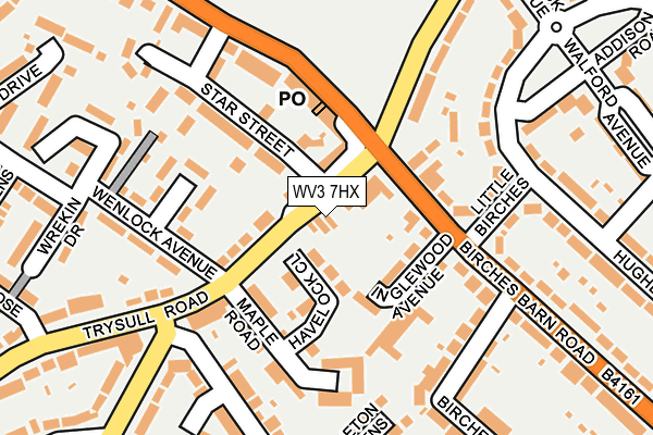
WV3 7HX lies on Trysull Road in Wolverhampton. WV3 7HX is located in the Graiseley electoral ward, within the metropolitan district of Wolverhampton and the English Parliamentary constituency of Wolverhampton South West. The Sub Integrated Care Board (ICB) Location is NHS Black Country ICB - D2P2L and the police force is West Midlands. This postcode has been in use since January 1980.


GetTheData
Source: OS OpenMap – Local (Ordnance Survey)
Source: OS VectorMap District (Ordnance Survey)
Licence: Open Government Licence (requires attribution)
| Easting | 389522 |
| Northing | 297602 |
| Latitude | 52.576132 |
| Longitude | -2.156049 |
GetTheData
Source: Open Postcode Geo
Licence: Open Government Licence
| Street | Trysull Road |
| Town/City | Wolverhampton |
| Country | England |
| Postcode District | WV3 |
➜ See where WV3 is on a map ➜ Where is Wolverhampton? | |
GetTheData
Source: Land Registry Price Paid Data
Licence: Open Government Licence
Elevation or altitude of WV3 7HX as distance above sea level:
| Metres | Feet | |
|---|---|---|
| Elevation | 130m | 427ft |
Elevation is measured from the approximate centre of the postcode, to the nearest point on an OS contour line from OS Terrain 50, which has contour spacing of ten vertical metres.
➜ How high above sea level am I? Find the elevation of your current position using your device's GPS.
GetTheData
Source: Open Postcode Elevation
Licence: Open Government Licence
| Ward | Graiseley |
| Constituency | Wolverhampton South West |
GetTheData
Source: ONS Postcode Database
Licence: Open Government Licence
| Bradmore Inn (Bradmore Rd) | Bradmore | 156m |
| Bradmore Inn (Bradmore Rd) | Bradmore | 158m |
| Little Birches (Hughes Ave) | Bradmore | 179m |
| Little Birches (Hughes Ave) | Bradmore | 195m |
| Oxbarn Avenue (Trysull Rd) | Bradmore | 215m |
| Wolverhampton Station | 2.8km |
| Coseley Station | 5.9km |
GetTheData
Source: NaPTAN
Licence: Open Government Licence
| Percentage of properties with Next Generation Access | 100.0% |
| Percentage of properties with Superfast Broadband | 100.0% |
| Percentage of properties with Ultrafast Broadband | 25.0% |
| Percentage of properties with Full Fibre Broadband | 0.0% |
Superfast Broadband is between 30Mbps and 300Mbps
Ultrafast Broadband is > 300Mbps
| Percentage of properties unable to receive 2Mbps | 0.0% |
| Percentage of properties unable to receive 5Mbps | 0.0% |
| Percentage of properties unable to receive 10Mbps | 0.0% |
| Percentage of properties unable to receive 30Mbps | 0.0% |
GetTheData
Source: Ofcom
Licence: Ofcom Terms of Use (requires attribution)
GetTheData
Source: ONS Postcode Database
Licence: Open Government Licence


➜ Get more ratings from the Food Standards Agency
GetTheData
Source: Food Standards Agency
Licence: FSA terms & conditions
| Last Collection | |||
|---|---|---|---|
| Location | Mon-Fri | Sat | Distance |
| Bradmore Post Office | 16:45 | 12:00 | 111m |
| Broad Lane | 17:30 | 12:00 | 364m |
| Walford Avenue | 17:00 | 12:45 | 397m |
GetTheData
Source: Dracos
Licence: Creative Commons Attribution-ShareAlike
The below table lists the International Territorial Level (ITL) codes (formerly Nomenclature of Territorial Units for Statistics (NUTS) codes) and Local Administrative Units (LAU) codes for WV3 7HX:
| ITL 1 Code | Name |
|---|---|
| TLG | West Midlands (England) |
| ITL 2 Code | Name |
| TLG3 | West Midlands |
| ITL 3 Code | Name |
| TLG39 | Wolverhampton |
| LAU 1 Code | Name |
| E08000031 | Wolverhampton |
GetTheData
Source: ONS Postcode Directory
Licence: Open Government Licence
The below table lists the Census Output Area (OA), Lower Layer Super Output Area (LSOA), and Middle Layer Super Output Area (MSOA) for WV3 7HX:
| Code | Name | |
|---|---|---|
| OA | E00052845 | |
| LSOA | E01010468 | Wolverhampton 026B |
| MSOA | E02002174 | Wolverhampton 026 |
GetTheData
Source: ONS Postcode Directory
Licence: Open Government Licence
| WV3 7HS | Havelock Close | 48m |
| WV3 7HU | Trysull Road | 55m |
| WV3 7HT | Trysull Road | 56m |
| WV3 9BJ | Broad Lane | 79m |
| WV3 7BP | Inglewood Avenue | 79m |
| WV3 7JD | Maple Road | 118m |
| WV3 7JB | Minsterley Close | 127m |
| WV3 7BW | Birches Barn Road | 127m |
| WV3 7JE | Trysull Road | 131m |
| WV3 9BN | Broad Lane | 131m |
GetTheData
Source: Open Postcode Geo; Land Registry Price Paid Data
Licence: Open Government Licence