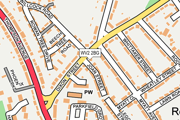
WV2 2BG lies on Dixon Street in Wolverhampton. WV2 2BG is located in the Ettingshall North electoral ward, within the metropolitan district of Wolverhampton and the English Parliamentary constituency of Wolverhampton South East. The Sub Integrated Care Board (ICB) Location is NHS Black Country ICB - D2P2L and the police force is West Midlands. This postcode has been in use since January 1980.


GetTheData
Source: OS OpenMap – Local (Ordnance Survey)
Source: OS VectorMap District (Ordnance Survey)
Licence: Open Government Licence (requires attribution)
| Easting | 392278 |
| Northing | 296938 |
| Latitude | 52.570209 |
| Longitude | -2.115365 |
GetTheData
Source: Open Postcode Geo
Licence: Open Government Licence
| Street | Dixon Street |
| Town/City | Wolverhampton |
| Country | England |
| Postcode District | WV2 |
➜ See where WV2 is on a map ➜ Where is Wolverhampton? | |
GetTheData
Source: Land Registry Price Paid Data
Licence: Open Government Licence
Elevation or altitude of WV2 2BG as distance above sea level:
| Metres | Feet | |
|---|---|---|
| Elevation | 150m | 492ft |
Elevation is measured from the approximate centre of the postcode, to the nearest point on an OS contour line from OS Terrain 50, which has contour spacing of ten vertical metres.
➜ How high above sea level am I? Find the elevation of your current position using your device's GPS.
GetTheData
Source: Open Postcode Elevation
Licence: Open Government Licence
| Ward | Ettingshall North |
| Constituency | Wolverhampton South East |
GetTheData
Source: ONS Postcode Database
Licence: Open Government Licence
| Whittaker St (Dixon St) | Rough Hills | 125m |
| Whittaker St (Dixon St) | Rough Hills | 165m |
| The Black Horse (Thompson Ave) | Rough Hills | 203m |
| The Black Horse (Thompson Ave) | Rough Hills | 204m |
| Dixon St (Cheviot Rd) | Rough Hills | 330m |
| Priestfield (Midland Metro Stop) (Junction Rd) | Priestfield | 1,210m |
| The Royal (Midland Metro Stop) (Bilston St) | Wolverhampton | 1,251m |
| Wolverhampton Station | 2km |
| Coseley Station | 3.4km |
| Tipton Station | 5.6km |
GetTheData
Source: NaPTAN
Licence: Open Government Licence
| Percentage of properties with Next Generation Access | 100.0% |
| Percentage of properties with Superfast Broadband | 100.0% |
| Percentage of properties with Ultrafast Broadband | 100.0% |
| Percentage of properties with Full Fibre Broadband | 0.0% |
Superfast Broadband is between 30Mbps and 300Mbps
Ultrafast Broadband is > 300Mbps
| Median download speed | 50.0Mbps |
| Average download speed | 71.7Mbps |
| Maximum download speed | 350.00Mbps |
| Median upload speed | 1.1Mbps |
| Average upload speed | 4.2Mbps |
| Maximum upload speed | 9.99Mbps |
| Percentage of properties unable to receive 2Mbps | 0.0% |
| Percentage of properties unable to receive 5Mbps | 0.0% |
| Percentage of properties unable to receive 10Mbps | 0.0% |
| Percentage of properties unable to receive 30Mbps | 0.0% |
GetTheData
Source: Ofcom
Licence: Ofcom Terms of Use (requires attribution)
Estimated total energy consumption in WV2 2BG by fuel type, 2015.
| Consumption (kWh) | 331,642 |
|---|---|
| Meter count | 28 |
| Mean (kWh/meter) | 11,844 |
| Median (kWh/meter) | 11,931 |
| Consumption (kWh) | 99,023 |
|---|---|
| Meter count | 24 |
| Mean (kWh/meter) | 4,126 |
| Median (kWh/meter) | 3,614 |
GetTheData
Source: Postcode level gas estimates: 2015 (experimental)
Source: Postcode level electricity estimates: 2015 (experimental)
Licence: Open Government Licence
GetTheData
Source: ONS Postcode Database
Licence: Open Government Licence


➜ Get more ratings from the Food Standards Agency
GetTheData
Source: Food Standards Agency
Licence: FSA terms & conditions
| Last Collection | |||
|---|---|---|---|
| Location | Mon-Fri | Sat | Distance |
| Dixon Street | 17:00 | 12:30 | 200m |
| Wolverhampton Road East | 16:45 | 12:00 | 594m |
| Ettingshall Road | 17:30 | 12:00 | 869m |
GetTheData
Source: Dracos
Licence: Creative Commons Attribution-ShareAlike
The below table lists the International Territorial Level (ITL) codes (formerly Nomenclature of Territorial Units for Statistics (NUTS) codes) and Local Administrative Units (LAU) codes for WV2 2BG:
| ITL 1 Code | Name |
|---|---|
| TLG | West Midlands (England) |
| ITL 2 Code | Name |
| TLG3 | West Midlands |
| ITL 3 Code | Name |
| TLG39 | Wolverhampton |
| LAU 1 Code | Name |
| E08000031 | Wolverhampton |
GetTheData
Source: ONS Postcode Directory
Licence: Open Government Licence
The below table lists the Census Output Area (OA), Lower Layer Super Output Area (LSOA), and Middle Layer Super Output Area (MSOA) for WV2 2BG:
| Code | Name | |
|---|---|---|
| OA | E00052769 | |
| LSOA | E01010453 | Wolverhampton 035F |
| MSOA | E02006894 | Wolverhampton 035 |
GetTheData
Source: ONS Postcode Directory
Licence: Open Government Licence
| WV2 2DQ | Joan Street | 74m |
| WV2 2ED | Myatt Avenue | 92m |
| WV2 2BE | Dixon Street | 93m |
| WV2 2BQ | St Martins Close | 93m |
| WV2 2FD | Beech Tree Road | 112m |
| WV2 2BH | Dixon Street | 161m |
| WV2 2DJ | Myatt Close | 169m |
| WV2 2EB | Whittaker Street | 169m |
| WV2 2DA | Willcock Road | 187m |
| WV2 2FB | Rowan Tree Drive | 193m |
GetTheData
Source: Open Postcode Geo; Land Registry Price Paid Data
Licence: Open Government Licence