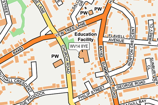
WV14 8YE is located in the Coseley East electoral ward, within the metropolitan district of Dudley and the English Parliamentary constituency of Wolverhampton South East. The Sub Integrated Care Board (ICB) Location is NHS Black Country ICB - D2P2L and the police force is West Midlands. This postcode has been in use since January 1995.


GetTheData
Source: OS OpenMap – Local (Ordnance Survey)
Source: OS VectorMap District (Ordnance Survey)
Licence: Open Government Licence (requires attribution)
| Easting | 394758 |
| Northing | 294291 |
| Latitude | 52.546459 |
| Longitude | -2.078726 |
GetTheData
Source: Open Postcode Geo
Licence: Open Government Licence
| Country | England |
| Postcode District | WV14 |
➜ See where WV14 is on a map ➜ Where is Coseley? | |
GetTheData
Source: Land Registry Price Paid Data
Licence: Open Government Licence
Elevation or altitude of WV14 8YE as distance above sea level:
| Metres | Feet | |
|---|---|---|
| Elevation | 160m | 525ft |
Elevation is measured from the approximate centre of the postcode, to the nearest point on an OS contour line from OS Terrain 50, which has contour spacing of ten vertical metres.
➜ How high above sea level am I? Find the elevation of your current position using your device's GPS.
GetTheData
Source: Open Postcode Elevation
Licence: Open Government Licence
| Ward | Coseley East |
| Constituency | Wolverhampton South East |
GetTheData
Source: ONS Postcode Database
Licence: Open Government Licence
| Norton Crescent (Summer Hill Rd) | Wallbrook | 94m |
| Church Rd (Yew Tree Lane) | Coseley | 103m |
| Norton Crescent (Summer Hill Rd) | Wallbrook | 110m |
| Church Rd (Yew Tree Lane) | Coseley | 118m |
| Flavell Avenue (Harding St) | Wallbrook | 132m |
| Loxdale (Midland Metro Stop) (Loxdale St) | Bradley | 1,736m |
| Bradley Lane (Midland Metro Stop) (Bradley Lane) | Lower Bradley | 1,778m |
| Coseley Station | 0.5km |
| Tipton Station | 2km |
| Dudley Port Station | 3.1km |
GetTheData
Source: NaPTAN
Licence: Open Government Licence
GetTheData
Source: ONS Postcode Database
Licence: Open Government Licence

➜ Get more ratings from the Food Standards Agency
GetTheData
Source: Food Standards Agency
Licence: FSA terms & conditions
| Last Collection | |||
|---|---|---|---|
| Location | Mon-Fri | Sat | Distance |
| Church Road P.o. Box | 17:00 | 12:00 | 116m |
| Siddons Road | 17:00 | 12:00 | 395m |
| Dimmocks Avenue | 17:00 | 11:00 | 488m |
GetTheData
Source: Dracos
Licence: Creative Commons Attribution-ShareAlike
The below table lists the International Territorial Level (ITL) codes (formerly Nomenclature of Territorial Units for Statistics (NUTS) codes) and Local Administrative Units (LAU) codes for WV14 8YE:
| ITL 1 Code | Name |
|---|---|
| TLG | West Midlands (England) |
| ITL 2 Code | Name |
| TLG3 | West Midlands |
| ITL 3 Code | Name |
| TLG36 | Dudley |
| LAU 1 Code | Name |
| E08000027 | Dudley |
GetTheData
Source: ONS Postcode Directory
Licence: Open Government Licence
The below table lists the Census Output Area (OA), Lower Layer Super Output Area (LSOA), and Middle Layer Super Output Area (MSOA) for WV14 8YE:
| Code | Name | |
|---|---|---|
| OA | E00049415 | |
| LSOA | E01009763 | Dudley 001A |
| MSOA | E02002000 | Dudley 001 |
GetTheData
Source: ONS Postcode Directory
Licence: Open Government Licence
| WV14 8XN | Highland Mews | 86m |
| WV14 8RE | Summerhill Road | 89m |
| WV14 8YB | Church Road | 110m |
| WV14 8YF | Philip Street | 129m |
| WV14 8RF | Yew Tree Lane | 134m |
| WV14 8QT | Flavell Avenue | 153m |
| WV14 8QU | Norton Crescent | 168m |
| WV14 8YA | The Paddock | 180m |
| WV14 8RG | Salcombe Grove | 203m |
| WV14 8XU | Ribbesford Crescent | 208m |
GetTheData
Source: Open Postcode Geo; Land Registry Price Paid Data
Licence: Open Government Licence