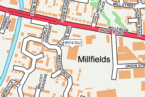
WV14 0UJ is located in the Ettingshall North electoral ward, within the metropolitan district of Wolverhampton and the English Parliamentary constituency of Wolverhampton South East. The Sub Integrated Care Board (ICB) Location is NHS Black Country ICB - D2P2L and the police force is West Midlands. This postcode has been in use since June 2002.


GetTheData
Source: OS OpenMap – Local (Ordnance Survey)
Source: OS VectorMap District (Ordnance Survey)
Licence: Open Government Licence (requires attribution)
| Easting | 394049 |
| Northing | 296217 |
| Latitude | 52.563766 |
| Longitude | -2.089216 |
GetTheData
Source: Open Postcode Geo
Licence: Open Government Licence
| Country | England |
| Postcode District | WV14 |
➜ See where WV14 is on a map ➜ Where is Bilston? | |
GetTheData
Source: Land Registry Price Paid Data
Licence: Open Government Licence
Elevation or altitude of WV14 0UJ as distance above sea level:
| Metres | Feet | |
|---|---|---|
| Elevation | 140m | 459ft |
Elevation is measured from the approximate centre of the postcode, to the nearest point on an OS contour line from OS Terrain 50, which has contour spacing of ten vertical metres.
➜ How high above sea level am I? Find the elevation of your current position using your device's GPS.
GetTheData
Source: Open Postcode Elevation
Licence: Open Government Licence
| Ward | Ettingshall North |
| Constituency | Wolverhampton South East |
GetTheData
Source: ONS Postcode Database
Licence: Open Government Licence
| Chem Rd (Millfields Rd) | Bilston | 47m |
| Chem Rd (Millfields Rd) | Bilston | 99m |
| Tarmac Rd (Millfields Rd) | Priestfield | 159m |
| Hickman Rd (Millfields Rd) | Bilston | 210m |
| Tarmac Rd (Millfields Rd) | Priestfield | 320m |
| The Crescent (Midland Metro Stop) (The Crescent) | Bilston | 739m |
| Bilston Central (Midland Metro Stop) (Church St) | Bilston | 998m |
| Priestfield (Midland Metro Stop) (Junction Rd) | Priestfield | 1,046m |
| Coseley Station | 2.1km |
| Wolverhampton Station | 3.4km |
| Tipton Station | 4km |
GetTheData
Source: NaPTAN
Licence: Open Government Licence
GetTheData
Source: ONS Postcode Database
Licence: Open Government Licence

➜ Get more ratings from the Food Standards Agency
GetTheData
Source: Food Standards Agency
Licence: FSA terms & conditions
| Last Collection | |||
|---|---|---|---|
| Location | Mon-Fri | Sat | Distance |
| Village Way | 19:00 | 12:00 | 57m |
| High Street Post Office | 19:00 | 11:45 | 591m |
| Lyndhurst | 18:45 | 11:15 | 671m |
GetTheData
Source: Dracos
Licence: Creative Commons Attribution-ShareAlike
The below table lists the International Territorial Level (ITL) codes (formerly Nomenclature of Territorial Units for Statistics (NUTS) codes) and Local Administrative Units (LAU) codes for WV14 0UJ:
| ITL 1 Code | Name |
|---|---|
| TLG | West Midlands (England) |
| ITL 2 Code | Name |
| TLG3 | West Midlands |
| ITL 3 Code | Name |
| TLG39 | Wolverhampton |
| LAU 1 Code | Name |
| E08000031 | Wolverhampton |
GetTheData
Source: ONS Postcode Directory
Licence: Open Government Licence
The below table lists the Census Output Area (OA), Lower Layer Super Output Area (LSOA), and Middle Layer Super Output Area (MSOA) for WV14 0UJ:
| Code | Name | |
|---|---|---|
| OA | E00052784 | |
| LSOA | E01010451 | Wolverhampton 029C |
| MSOA | E02002177 | Wolverhampton 029 |
GetTheData
Source: ONS Postcode Directory
Licence: Open Government Licence
| WV14 0QR | Millfields Road | 60m |
| WV14 0RA | Gordon Place | 111m |
| WV14 0QY | Chem Road | 118m |
| WV14 0UA | Chorley Gardens | 154m |
| WV14 0QX | Millfields Road | 165m |
| WV14 0QZ | Livingstone Road | 165m |
| WV14 0UN | Weston Drive | 172m |
| WV14 0UF | Hodnet Close | 185m |
| WV14 0UH | Rushbury Close | 185m |
| WV14 0RE | Stanley Place | 188m |
GetTheData
Source: Open Postcode Geo; Land Registry Price Paid Data
Licence: Open Government Licence