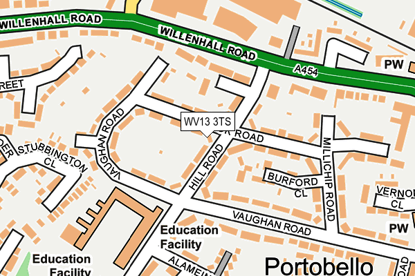
WV13 3TS lies on Hill Road in Willenhall. WV13 3TS is located in the East Park electoral ward, within the metropolitan district of Wolverhampton and the English Parliamentary constituency of Wolverhampton South East. The Sub Integrated Care Board (ICB) Location is NHS Black Country ICB - D2P2L and the police force is West Midlands. This postcode has been in use since January 1980.


GetTheData
Source: OS OpenMap – Local (Ordnance Survey)
Source: OS VectorMap District (Ordnance Survey)
Licence: Open Government Licence (requires attribution)
| Easting | 395113 |
| Northing | 298296 |
| Latitude | 52.582451 |
| Longitude | -2.073557 |
GetTheData
Source: Open Postcode Geo
Licence: Open Government Licence
| Street | Hill Road |
| Town/City | Willenhall |
| Country | England |
| Postcode District | WV13 |
➜ See where WV13 is on a map ➜ Where is Wolverhampton? | |
GetTheData
Source: Land Registry Price Paid Data
Licence: Open Government Licence
Elevation or altitude of WV13 3TS as distance above sea level:
| Metres | Feet | |
|---|---|---|
| Elevation | 130m | 427ft |
Elevation is measured from the approximate centre of the postcode, to the nearest point on an OS contour line from OS Terrain 50, which has contour spacing of ten vertical metres.
➜ How high above sea level am I? Find the elevation of your current position using your device's GPS.
GetTheData
Source: Open Postcode Elevation
Licence: Open Government Licence
| Ward | East Park |
| Constituency | Wolverhampton South East |
GetTheData
Source: ONS Postcode Database
Licence: Open Government Licence
| Hill Rd (Vaughan Rd) | Portobello | 99m |
| Hill Rd (Vaughan Rd) | Portobello | 104m |
| Noose Lane (Willenhall Rd) | Portobello | 114m |
| Noose Lane (Willenhall Rd) | Portobello | 181m |
| Portobello Island (Willenhall Rd) | Portobello | 325m |
| Wolverhampton Station | 3.2km |
| Coseley Station | 4.2km |
| Bloxwich Station | 5.8km |
GetTheData
Source: NaPTAN
Licence: Open Government Licence
| Percentage of properties with Next Generation Access | 100.0% |
| Percentage of properties with Superfast Broadband | 100.0% |
| Percentage of properties with Ultrafast Broadband | 100.0% |
| Percentage of properties with Full Fibre Broadband | 0.0% |
Superfast Broadband is between 30Mbps and 300Mbps
Ultrafast Broadband is > 300Mbps
| Median download speed | 79.5Mbps |
| Average download speed | 83.9Mbps |
| Maximum download speed | 200.00Mbps |
| Median upload speed | 10.0Mbps |
| Average upload speed | 11.1Mbps |
| Maximum upload speed | 20.00Mbps |
| Percentage of properties unable to receive 2Mbps | 0.0% |
| Percentage of properties unable to receive 5Mbps | 0.0% |
| Percentage of properties unable to receive 10Mbps | 0.0% |
| Percentage of properties unable to receive 30Mbps | 0.0% |
GetTheData
Source: Ofcom
Licence: Ofcom Terms of Use (requires attribution)
Estimated total energy consumption in WV13 3TS by fuel type, 2015.
| Consumption (kWh) | 166,441 |
|---|---|
| Meter count | 16 |
| Mean (kWh/meter) | 10,403 |
| Median (kWh/meter) | 10,007 |
| Consumption (kWh) | 95,406 |
|---|---|
| Meter count | 15 |
| Mean (kWh/meter) | 6,360 |
| Median (kWh/meter) | 4,665 |
GetTheData
Source: Postcode level gas estimates: 2015 (experimental)
Source: Postcode level electricity estimates: 2015 (experimental)
Licence: Open Government Licence
GetTheData
Source: ONS Postcode Database
Licence: Open Government Licence


➜ Get more ratings from the Food Standards Agency
GetTheData
Source: Food Standards Agency
Licence: FSA terms & conditions
| Last Collection | |||
|---|---|---|---|
| Location | Mon-Fri | Sat | Distance |
| New Road | 17:30 | 12:00 | 1,095m |
| Stafford Street | 17:30 | 12:00 | 1,229m |
| Lichfield Street Post Office | 19:30 | 12:30 | 1,272m |
GetTheData
Source: Dracos
Licence: Creative Commons Attribution-ShareAlike
The below table lists the International Territorial Level (ITL) codes (formerly Nomenclature of Territorial Units for Statistics (NUTS) codes) and Local Administrative Units (LAU) codes for WV13 3TS:
| ITL 1 Code | Name |
|---|---|
| TLG | West Midlands (England) |
| ITL 2 Code | Name |
| TLG3 | West Midlands |
| ITL 3 Code | Name |
| TLG39 | Wolverhampton |
| LAU 1 Code | Name |
| E08000031 | Wolverhampton |
GetTheData
Source: ONS Postcode Directory
Licence: Open Government Licence
The below table lists the Census Output Area (OA), Lower Layer Super Output Area (LSOA), and Middle Layer Super Output Area (MSOA) for WV13 3TS:
| Code | Name | |
|---|---|---|
| OA | E00052619 | |
| LSOA | E01010423 | Wolverhampton 022C |
| MSOA | E02002170 | Wolverhampton 022 |
GetTheData
Source: ONS Postcode Directory
Licence: Open Government Licence
| WV13 3TR | Hill Road | 52m |
| WV13 3UH | Brook Road | 57m |
| WV13 3QU | Willenhall Road | 96m |
| WV13 3UJ | Brook Road | 99m |
| WV13 3UD | Vaughan Road | 127m |
| WV13 3TJ | Vaughan Road | 170m |
| WV13 3RA | Willenhall Road | 180m |
| WV13 3UL | Millichip Road | 197m |
| WV13 3QZ | Willenhall Road | 202m |
| WV13 3LH | Willenhall Road | 249m |
GetTheData
Source: Open Postcode Geo; Land Registry Price Paid Data
Licence: Open Government Licence