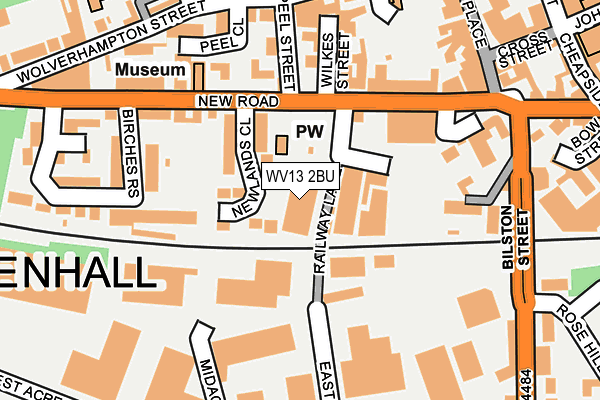
WV13 2BU is located in the Willenhall South electoral ward, within the metropolitan district of Walsall and the English Parliamentary constituency of Walsall North. The Sub Integrated Care Board (ICB) Location is NHS Black Country ICB - D2P2L and the police force is West Midlands. This postcode has been in use since June 2012.


GetTheData
Source: OS OpenMap – Local (Ordnance Survey)
Source: OS VectorMap District (Ordnance Survey)
Licence: Open Government Licence (requires attribution)
| Easting | 396198 |
| Northing | 298280 |
| Latitude | 52.582316 |
| Longitude | -2.057544 |
GetTheData
Source: Open Postcode Geo
Licence: Open Government Licence
| Country | England |
| Postcode District | WV13 |
➜ See where WV13 is on a map ➜ Where is Willenhall? | |
GetTheData
Source: Land Registry Price Paid Data
Licence: Open Government Licence
Elevation or altitude of WV13 2BU as distance above sea level:
| Metres | Feet | |
|---|---|---|
| Elevation | 130m | 427ft |
Elevation is measured from the approximate centre of the postcode, to the nearest point on an OS contour line from OS Terrain 50, which has contour spacing of ten vertical metres.
➜ How high above sea level am I? Find the elevation of your current position using your device's GPS.
GetTheData
Source: Open Postcode Elevation
Licence: Open Government Licence
| Ward | Willenhall South |
| Constituency | Walsall North |
GetTheData
Source: ONS Postcode Database
Licence: Open Government Licence
| Newlands Close (New Rd) | Willenhall | 121m |
| Newlands Close (New Rd) | Willenhall | 135m |
| Wilkes St (New Rd) | Willenhall | 151m |
| Market Place (New Rd) | Willenhall | 214m |
| Market Place (New Rd) | Willenhall | 223m |
| Wolverhampton Station | 4.2km |
| Coseley Station | 4.6km |
| Walsall Station | 4.9km |
GetTheData
Source: NaPTAN
Licence: Open Government Licence
GetTheData
Source: ONS Postcode Database
Licence: Open Government Licence


➜ Get more ratings from the Food Standards Agency
GetTheData
Source: Food Standards Agency
Licence: FSA terms & conditions
| Last Collection | |||
|---|---|---|---|
| Location | Mon-Fri | Sat | Distance |
| New Road | 17:30 | 12:00 | 103m |
| Lichfield Street Post Office | 19:30 | 12:30 | 203m |
| Stafford Street | 17:30 | 12:00 | 262m |
GetTheData
Source: Dracos
Licence: Creative Commons Attribution-ShareAlike
The below table lists the International Territorial Level (ITL) codes (formerly Nomenclature of Territorial Units for Statistics (NUTS) codes) and Local Administrative Units (LAU) codes for WV13 2BU:
| ITL 1 Code | Name |
|---|---|
| TLG | West Midlands (England) |
| ITL 2 Code | Name |
| TLG3 | West Midlands |
| ITL 3 Code | Name |
| TLG38 | Walsall |
| LAU 1 Code | Name |
| E08000030 | Walsall |
GetTheData
Source: ONS Postcode Directory
Licence: Open Government Licence
The below table lists the Census Output Area (OA), Lower Layer Super Output Area (LSOA), and Middle Layer Super Output Area (MSOA) for WV13 2BU:
| Code | Name | |
|---|---|---|
| OA | E00052551 | |
| LSOA | E01010404 | Walsall 025C |
| MSOA | E02002134 | Walsall 025 |
GetTheData
Source: ONS Postcode Directory
Licence: Open Government Licence
| WV13 2DQ | Newlands Close | 59m |
| WV13 2PT | Peel Close | 142m |
| WV13 2BG | New Road | 158m |
| WV13 2BJ | Ensdale Row | 158m |
| WV13 2BZ | Peel Street | 162m |
| WV13 2DA | New Road | 177m |
| WV13 2DB | Birches Rise | 214m |
| WV13 2NF | Wolverhampton Street | 218m |
| WV13 2PS | Wolverhampton Street | 221m |
| WV13 2AW | Bilston Street | 236m |
GetTheData
Source: Open Postcode Geo; Land Registry Price Paid Data
Licence: Open Government Licence