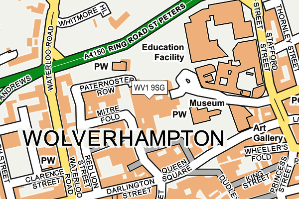
WV1 9SG is located in the St Peters electoral ward, within the metropolitan district of Wolverhampton and the English Parliamentary constituency of Wolverhampton South West. The Sub Integrated Care Board (ICB) Location is NHS Black Country ICB - D2P2L and the police force is West Midlands. This postcode has been in use since February 2005.


GetTheData
Source: OS OpenMap – Local (Ordnance Survey)
Source: OS VectorMap District (Ordnance Survey)
Licence: Open Government Licence (requires attribution)
| Easting | 391314 |
| Northing | 298823 |
| Latitude | 52.587140 |
| Longitude | -2.129638 |
GetTheData
Source: Open Postcode Geo
Licence: Open Government Licence
| Country | England |
| Postcode District | WV1 |
➜ See where WV1 is on a map ➜ Where is Wolverhampton? | |
GetTheData
Source: Land Registry Price Paid Data
Licence: Open Government Licence
Elevation or altitude of WV1 9SG as distance above sea level:
| Metres | Feet | |
|---|---|---|
| Elevation | 150m | 492ft |
Elevation is measured from the approximate centre of the postcode, to the nearest point on an OS contour line from OS Terrain 50, which has contour spacing of ten vertical metres.
➜ How high above sea level am I? Find the elevation of your current position using your device's GPS.
GetTheData
Source: Open Postcode Elevation
Licence: Open Government Licence
| Ward | St Peters |
| Constituency | Wolverhampton South West |
GetTheData
Source: ONS Postcode Database
Licence: Open Government Licence
| Beatties (Darlington St) | Wolverhampton | 162m |
| Art Gallery (Lichfield St) | Wolverhampton | 179m |
| Beatties (Darlington St) | Wolverhampton | 191m |
| Art Gallery (Lichfield St) | Wolverhampton | 194m |
| Beatties (Darlington St) | Wolverhampton | 201m |
| Wolverhampton St George's (Midland Metro Stop) (Bilston St) | Wolverhampton | 500m |
| The Royal (Midland Metro Stop) (Bilston St) | Wolverhampton | 1,035m |
| Wolverhampton Station | 0.7km |
| Coseley Station | 5.5km |
| Bilbrook Station | 5.6km |
GetTheData
Source: NaPTAN
Licence: Open Government Licence
GetTheData
Source: ONS Postcode Database
Licence: Open Government Licence


➜ Get more ratings from the Food Standards Agency
GetTheData
Source: Food Standards Agency
Licence: FSA terms & conditions
| Last Collection | |||
|---|---|---|---|
| Location | Mon-Fri | Sat | Distance |
| Waterloo Road | 18:30 | 12:00 | 186m |
| Mander Square | 17:30 | 12:30 | 269m |
| Darlington Street Post Office | 18:30 | 12:15 | 313m |
GetTheData
Source: Dracos
Licence: Creative Commons Attribution-ShareAlike
The below table lists the International Territorial Level (ITL) codes (formerly Nomenclature of Territorial Units for Statistics (NUTS) codes) and Local Administrative Units (LAU) codes for WV1 9SG:
| ITL 1 Code | Name |
|---|---|
| TLG | West Midlands (England) |
| ITL 2 Code | Name |
| TLG3 | West Midlands |
| ITL 3 Code | Name |
| TLG39 | Wolverhampton |
| LAU 1 Code | Name |
| E08000031 | Wolverhampton |
GetTheData
Source: ONS Postcode Directory
Licence: Open Government Licence
The below table lists the Census Output Area (OA), Lower Layer Super Output Area (LSOA), and Middle Layer Super Output Area (MSOA) for WV1 9SG:
| Code | Name | |
|---|---|---|
| OA | E00167323 | |
| LSOA | E01010521 | Wolverhampton 020F |
| MSOA | E02002168 | Wolverhampton 020 |
GetTheData
Source: ONS Postcode Directory
Licence: Open Government Licence
| WV1 4BN | Waterloo Road | 176m |
| WV1 4DG | Waterloo Road | 177m |
| WV1 4BL | Waterloo Road | 180m |
| WV1 4DJ | Waterloo Road | 207m |
| WV1 1DG | Lichfield Street | 215m |
| WV1 4HW | Darlington Street | 218m |
| WV1 1NA | Stafford Street | 266m |
| WV1 4QL | Waterloo Road | 267m |
| WV1 4QQ | Waterloo Road | 270m |
| WV1 1JA | Broad Street | 273m |
GetTheData
Source: Open Postcode Geo; Land Registry Price Paid Data
Licence: Open Government Licence