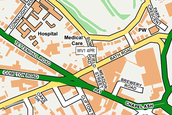
WV1 4PR lies on Summerfield Road in Wolverhampton. WV1 4PR is located in the Park electoral ward, within the metropolitan district of Wolverhampton and the English Parliamentary constituency of Wolverhampton South West. The Sub Integrated Care Board (ICB) Location is NHS Black Country ICB - D2P2L and the police force is West Midlands. This postcode has been in use since January 1980.


GetTheData
Source: OS OpenMap – Local (Ordnance Survey)
Source: OS VectorMap District (Ordnance Survey)
Licence: Open Government Licence (requires attribution)
| Easting | 390655 |
| Northing | 298720 |
| Latitude | 52.586203 |
| Longitude | -2.139362 |
GetTheData
Source: Open Postcode Geo
Licence: Open Government Licence
| Street | Summerfield Road |
| Town/City | Wolverhampton |
| Country | England |
| Postcode District | WV1 |
➜ See where WV1 is on a map ➜ Where is Wolverhampton? | |
GetTheData
Source: Land Registry Price Paid Data
Licence: Open Government Licence
Elevation or altitude of WV1 4PR as distance above sea level:
| Metres | Feet | |
|---|---|---|
| Elevation | 130m | 427ft |
Elevation is measured from the approximate centre of the postcode, to the nearest point on an OS contour line from OS Terrain 50, which has contour spacing of ten vertical metres.
➜ How high above sea level am I? Find the elevation of your current position using your device's GPS.
GetTheData
Source: Open Postcode Elevation
Licence: Open Government Licence
| Ward | Park |
| Constituency | Wolverhampton South West |
GetTheData
Source: ONS Postcode Database
Licence: Open Government Licence
| Compton Rd (Chapel Ash) | Wolverhampton | 102m |
| Compton Rd (Tettenhall Rd) | Merridale | 127m |
| Bath Road (Southgate) | Wolverhampton | 169m |
| Merridale Rd (Compton Rd) | Merridale | 183m |
| Banks's Brewery (Bath Rd) | Wolverhampton | 195m |
| Wolverhampton St George's (Midland Metro Stop) (Bilston St) | Wolverhampton | 1,052m |
| The Royal (Midland Metro Stop) (Bilston St) | Wolverhampton | 1,566m |
| Wolverhampton Station | 1.4km |
| Bilbrook Station | 5.2km |
| Coseley Station | 5.8km |
GetTheData
Source: NaPTAN
Licence: Open Government Licence
| Percentage of properties with Next Generation Access | 92.3% |
| Percentage of properties with Superfast Broadband | 92.3% |
| Percentage of properties with Ultrafast Broadband | 92.3% |
| Percentage of properties with Full Fibre Broadband | 0.0% |
Superfast Broadband is between 30Mbps and 300Mbps
Ultrafast Broadband is > 300Mbps
| Median download speed | 20.9Mbps |
| Average download speed | 19.8Mbps |
| Maximum download speed | 23.33Mbps |
| Median upload speed | 1.1Mbps |
| Average upload speed | 1.1Mbps |
| Maximum upload speed | 1.23Mbps |
| Percentage of properties unable to receive 2Mbps | 0.0% |
| Percentage of properties unable to receive 5Mbps | 0.0% |
| Percentage of properties unable to receive 10Mbps | 0.0% |
| Percentage of properties unable to receive 30Mbps | 0.0% |
GetTheData
Source: Ofcom
Licence: Ofcom Terms of Use (requires attribution)
Estimated total energy consumption in WV1 4PR by fuel type, 2015.
| Consumption (kWh) | 364,337 |
|---|---|
| Meter count | 15 |
| Mean (kWh/meter) | 24,289 |
| Median (kWh/meter) | 15,824 |
| Consumption (kWh) | 48,478 |
|---|---|
| Meter count | 12 |
| Mean (kWh/meter) | 4,040 |
| Median (kWh/meter) | 3,186 |
GetTheData
Source: Postcode level gas estimates: 2015 (experimental)
Source: Postcode level electricity estimates: 2015 (experimental)
Licence: Open Government Licence
GetTheData
Source: ONS Postcode Database
Licence: Open Government Licence


➜ Get more ratings from the Food Standards Agency
GetTheData
Source: Food Standards Agency
Licence: FSA terms & conditions
| Last Collection | |||
|---|---|---|---|
| Location | Mon-Fri | Sat | Distance |
| Chapel Ash Post Office | 18:15 | 12:25 | 154m |
| Connaught Road | 18:30 | 12:30 | 301m |
| Park Road East | 19:00 | 12:30 | 326m |
GetTheData
Source: Dracos
Licence: Creative Commons Attribution-ShareAlike
The below table lists the International Territorial Level (ITL) codes (formerly Nomenclature of Territorial Units for Statistics (NUTS) codes) and Local Administrative Units (LAU) codes for WV1 4PR:
| ITL 1 Code | Name |
|---|---|
| TLG | West Midlands (England) |
| ITL 2 Code | Name |
| TLG3 | West Midlands |
| ITL 3 Code | Name |
| TLG39 | Wolverhampton |
| LAU 1 Code | Name |
| E08000031 | Wolverhampton |
GetTheData
Source: ONS Postcode Directory
Licence: Open Government Licence
The below table lists the Census Output Area (OA), Lower Layer Super Output Area (LSOA), and Middle Layer Super Output Area (MSOA) for WV1 4PR:
| Code | Name | |
|---|---|---|
| OA | E00053032 | |
| LSOA | E01010508 | Wolverhampton 017B |
| MSOA | E02002165 | Wolverhampton 017 |
GetTheData
Source: ONS Postcode Directory
Licence: Open Government Licence
| WV1 4EP | Bath Road | 58m |
| WV3 0TY | Chapel Ash | 68m |
| WV1 4PP | Park Road West | 92m |
| WV3 0TT | Chapel Ash | 97m |
| WV1 4SB | Tettenhall Road | 104m |
| WV1 4PS | Park Road West | 123m |
| WV3 0UF | Chapel Ash | 129m |
| WV3 0TZ | Chapel Ash | 135m |
| WV1 4SA | Tettenhall Road | 161m |
| WV3 9NB | Tettenhall Road | 199m |
GetTheData
Source: Open Postcode Geo; Land Registry Price Paid Data
Licence: Open Government Licence