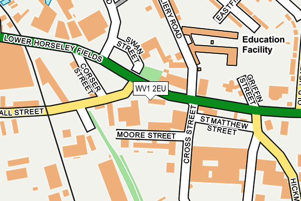
WV1 2EU is located in the East Park electoral ward, within the metropolitan district of Wolverhampton and the English Parliamentary constituency of Wolverhampton South East. The Sub Integrated Care Board (ICB) Location is NHS Black Country ICB - D2P2L and the police force is West Midlands. This postcode has been in use since January 1980.


GetTheData
Source: OS OpenMap – Local (Ordnance Survey)
Source: OS VectorMap District (Ordnance Survey)
Licence: Open Government Licence (requires attribution)
| Easting | 392677 |
| Northing | 298419 |
| Latitude | 52.583544 |
| Longitude | -2.109505 |
GetTheData
Source: Open Postcode Geo
Licence: Open Government Licence
| Country | England |
| Postcode District | WV1 |
➜ See where WV1 is on a map ➜ Where is Wolverhampton? | |
GetTheData
Source: Land Registry Price Paid Data
Licence: Open Government Licence
Elevation or altitude of WV1 2EU as distance above sea level:
| Metres | Feet | |
|---|---|---|
| Elevation | 140m | 459ft |
Elevation is measured from the approximate centre of the postcode, to the nearest point on an OS contour line from OS Terrain 50, which has contour spacing of ten vertical metres.
➜ How high above sea level am I? Find the elevation of your current position using your device's GPS.
GetTheData
Source: Open Postcode Elevation
Licence: Open Government Licence
| Ward | East Park |
| Constituency | Wolverhampton South East |
GetTheData
Source: ONS Postcode Database
Licence: Open Government Licence
| Corser St (Horseley Fields) | Monmore Green | 82m |
| Corser St (Horseley Fields) | Monmore Green | 112m |
| Hickman Avenue (Willenhall Rd) | Monmore Green | 251m |
| Canal Bridge (Horseley Fields) | Wolverhampton | 279m |
| Canal Bridge (Horseley Fields) | Wolverhampton | 287m |
| The Royal (Midland Metro Stop) (Bilston St) | Wolverhampton | 602m |
| Wolverhampton St George's (Midland Metro Stop) (Bilston St) | Wolverhampton | 1,000m |
| Priestfield (Midland Metro Stop) (Junction Rd) | Priestfield | 1,549m |
| Wolverhampton Station | 0.8km |
| Coseley Station | 4.6km |
GetTheData
Source: NaPTAN
Licence: Open Government Licence
GetTheData
Source: ONS Postcode Database
Licence: Open Government Licence


➜ Get more ratings from the Food Standards Agency
GetTheData
Source: Food Standards Agency
Licence: FSA terms & conditions
| Last Collection | |||
|---|---|---|---|
| Location | Mon-Fri | Sat | Distance |
| Deans Road | 17:30 | 12:00 | 578m |
| High Level Station | 18:30 | 12:15 | 862m |
| University Of Wolverhampton | 16:15 | 917m | |
GetTheData
Source: Dracos
Licence: Creative Commons Attribution-ShareAlike
The below table lists the International Territorial Level (ITL) codes (formerly Nomenclature of Territorial Units for Statistics (NUTS) codes) and Local Administrative Units (LAU) codes for WV1 2EU:
| ITL 1 Code | Name |
|---|---|
| TLG | West Midlands (England) |
| ITL 2 Code | Name |
| TLG3 | West Midlands |
| ITL 3 Code | Name |
| TLG39 | Wolverhampton |
| LAU 1 Code | Name |
| E08000031 | Wolverhampton |
GetTheData
Source: ONS Postcode Directory
Licence: Open Government Licence
The below table lists the Census Output Area (OA), Lower Layer Super Output Area (LSOA), and Middle Layer Super Output Area (MSOA) for WV1 2EU:
| Code | Name | |
|---|---|---|
| OA | E00052750 | |
| LSOA | E01010443 | Wolverhampton 018B |
| MSOA | E02002166 | Wolverhampton 018 |
GetTheData
Source: ONS Postcode Directory
Licence: Open Government Licence
| WV1 3EL | Corser Street | 96m |
| WV1 2HG | Willenhall Road | 150m |
| WV1 2QU | Colliery Road | 167m |
| WV1 2QZ | Colliery Road | 288m |
| WV1 2RF | Eastfield Grove | 323m |
| WV1 2RE | Eastfield Road | 366m |
| WV1 2SN | Old Heath Road | 384m |
| WV1 2RH | Eastfield Road | 402m |
| WV1 3RQ | Commercial Road | 429m |
| WV1 2SW | Old Heath Road | 440m |
GetTheData
Source: Open Postcode Geo; Land Registry Price Paid Data
Licence: Open Government Licence