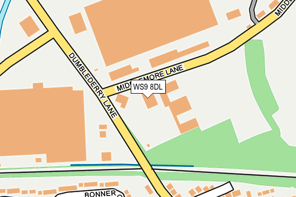
WS9 8DL is located in the Aldridge Central and South electoral ward, within the metropolitan district of Walsall and the English Parliamentary constituency of Aldridge-Brownhills. The Sub Integrated Care Board (ICB) Location is NHS Black Country ICB - D2P2L and the police force is West Midlands. This postcode has been in use since January 1980.


GetTheData
Source: OS OpenMap – Local (Ordnance Survey)
Source: OS VectorMap District (Ordnance Survey)
Licence: Open Government Licence (requires attribution)
| Easting | 404908 |
| Northing | 300644 |
| Latitude | 52.603576 |
| Longitude | -1.928958 |
GetTheData
Source: Open Postcode Geo
Licence: Open Government Licence
| Country | England |
| Postcode District | WS9 |
➜ See where WS9 is on a map ➜ Where is Aldridge? | |
GetTheData
Source: Land Registry Price Paid Data
Licence: Open Government Licence
Elevation or altitude of WS9 8DL as distance above sea level:
| Metres | Feet | |
|---|---|---|
| Elevation | 150m | 492ft |
Elevation is measured from the approximate centre of the postcode, to the nearest point on an OS contour line from OS Terrain 50, which has contour spacing of ten vertical metres.
➜ How high above sea level am I? Find the elevation of your current position using your device's GPS.
GetTheData
Source: Open Postcode Elevation
Licence: Open Government Licence
| Ward | Aldridge Central And South |
| Constituency | Aldridge-brownhills |
GetTheData
Source: ONS Postcode Database
Licence: Open Government Licence
| Dumbleberry Lane (Middlemore Lane) | Redhouse Industrial Estate | 87m |
| Dumbleberry Lane (Middlemore Lane) | Redhouse Industrial Estate | 91m |
| Middlemore Lane (Dumblederry Lane) | Redhouse Industrial Estate | 139m |
| Middlemore Lane (Dumblederry Lane) | Redhouse Industrial Estate | 162m |
| Speedwell Close (Dumblederry Lane) | Aldridge | 213m |
| Walsall Station | 4.3km |
| Bescot Stadium Station | 6.2km |
GetTheData
Source: NaPTAN
Licence: Open Government Licence
GetTheData
Source: ONS Postcode Database
Licence: Open Government Licence


➜ Get more ratings from the Food Standards Agency
GetTheData
Source: Food Standards Agency
Licence: FSA terms & conditions
| Last Collection | |||
|---|---|---|---|
| Location | Mon-Fri | Sat | Distance |
| Wharf Approach | 17:00 | 11:45 | 456m |
| Myatt Avenue | 17:15 | 11:00 | 507m |
| Tynings Lane | 17:00 | 11:00 | 589m |
GetTheData
Source: Dracos
Licence: Creative Commons Attribution-ShareAlike
The below table lists the International Territorial Level (ITL) codes (formerly Nomenclature of Territorial Units for Statistics (NUTS) codes) and Local Administrative Units (LAU) codes for WS9 8DL:
| ITL 1 Code | Name |
|---|---|
| TLG | West Midlands (England) |
| ITL 2 Code | Name |
| TLG3 | West Midlands |
| ITL 3 Code | Name |
| TLG38 | Walsall |
| LAU 1 Code | Name |
| E08000030 | Walsall |
GetTheData
Source: ONS Postcode Directory
Licence: Open Government Licence
The below table lists the Census Output Area (OA), Lower Layer Super Output Area (LSOA), and Middle Layer Super Output Area (MSOA) for WS9 8DL:
| Code | Name | |
|---|---|---|
| OA | E00168267 | |
| LSOA | E01010241 | Walsall 015A |
| MSOA | E02002124 | Walsall 015 |
GetTheData
Source: ONS Postcode Directory
Licence: Open Government Licence
| WS9 0DH | Dumblederry Lane | 212m |
| WS9 0DL | Speedwell Close | 220m |
| WS9 0DX | Bonner Grove | 223m |
| WS9 0DU | Bonner Grove | 254m |
| WS9 0DT | Gretton Road | 355m |
| WS9 0DQ | Redhouse Lane | 362m |
| WS9 0BN | Station Road | 363m |
| WS9 0BW | Station Road | 377m |
| WS9 8ZD | Westfield Drive | 378m |
| WS9 0DY | Gretton Crescent | 396m |
GetTheData
Source: Open Postcode Geo; Land Registry Price Paid Data
Licence: Open Government Licence