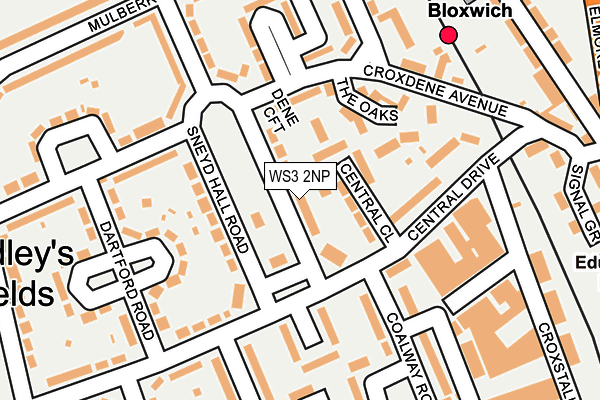
WS3 2NP lies on Sneyd Hall Road in Bloxwich, Walsall. WS3 2NP is located in the Bloxwich West electoral ward, within the metropolitan district of Walsall and the English Parliamentary constituency of Walsall North. The Sub Integrated Care Board (ICB) Location is NHS Black Country ICB - D2P2L and the police force is West Midlands. This postcode has been in use since January 1980.


GetTheData
Source: OS OpenMap – Local (Ordnance Survey)
Source: OS VectorMap District (Ordnance Survey)
Licence: Open Government Licence (requires attribution)
| Easting | 399157 |
| Northing | 302122 |
| Latitude | 52.616868 |
| Longitude | -2.013885 |
GetTheData
Source: Open Postcode Geo
Licence: Open Government Licence
| Street | Sneyd Hall Road |
| Locality | Bloxwich |
| Town/City | Walsall |
| Country | England |
| Postcode District | WS3 |
➜ See where WS3 is on a map ➜ Where is Bloxwich? | |
GetTheData
Source: Land Registry Price Paid Data
Licence: Open Government Licence
Elevation or altitude of WS3 2NP as distance above sea level:
| Metres | Feet | |
|---|---|---|
| Elevation | 160m | 525ft |
Elevation is measured from the approximate centre of the postcode, to the nearest point on an OS contour line from OS Terrain 50, which has contour spacing of ten vertical metres.
➜ How high above sea level am I? Find the elevation of your current position using your device's GPS.
GetTheData
Source: Open Postcode Elevation
Licence: Open Government Licence
| Ward | Bloxwich West |
| Constituency | Walsall North |
GetTheData
Source: ONS Postcode Database
Licence: Open Government Licence
| Central Drive (Sneyd Hall Rd) | Dudleys Field | 24m |
| Central Drive (Sneyd Hall Rd) | Dudleys Field | 82m |
| Chase Rd (Central Dr) | Dudleys Field | 116m |
| Central Close (Central Dr) | Dudleys Field | 121m |
| Central Close (Central Dr) | Dudleys Field | 124m |
| Bloxwich Station | 0.2km |
| Bloxwich North Station | 1km |
| Walsall Station | 4.1km |
GetTheData
Source: NaPTAN
Licence: Open Government Licence
| Percentage of properties with Next Generation Access | 100.0% |
| Percentage of properties with Superfast Broadband | 100.0% |
| Percentage of properties with Ultrafast Broadband | 87.5% |
| Percentage of properties with Full Fibre Broadband | 0.0% |
Superfast Broadband is between 30Mbps and 300Mbps
Ultrafast Broadband is > 300Mbps
| Median download speed | 77.8Mbps |
| Average download speed | 75.7Mbps |
| Maximum download speed | 200.00Mbps |
| Median upload speed | 10.0Mbps |
| Average upload speed | 12.4Mbps |
| Maximum upload speed | 20.00Mbps |
| Percentage of properties unable to receive 2Mbps | 0.0% |
| Percentage of properties unable to receive 5Mbps | 0.0% |
| Percentage of properties unable to receive 10Mbps | 0.0% |
| Percentage of properties unable to receive 30Mbps | 0.0% |
GetTheData
Source: Ofcom
Licence: Ofcom Terms of Use (requires attribution)
Estimated total energy consumption in WS3 2NP by fuel type, 2015.
| Consumption (kWh) | 242,128 |
|---|---|
| Meter count | 18 |
| Mean (kWh/meter) | 13,452 |
| Median (kWh/meter) | 12,613 |
| Consumption (kWh) | 57,608 |
|---|---|
| Meter count | 16 |
| Mean (kWh/meter) | 3,601 |
| Median (kWh/meter) | 3,348 |
GetTheData
Source: Postcode level gas estimates: 2015 (experimental)
Source: Postcode level electricity estimates: 2015 (experimental)
Licence: Open Government Licence
GetTheData
Source: ONS Postcode Database
Licence: Open Government Licence


➜ Get more ratings from the Food Standards Agency
GetTheData
Source: Food Standards Agency
Licence: FSA terms & conditions
| Last Collection | |||
|---|---|---|---|
| Location | Mon-Fri | Sat | Distance |
| Dudley Fields | 17:15 | 12:00 | 60m |
| Sandbank | 16:30 | 11:30 | 431m |
| Sneyd Lane | 14:45 | 12:00 | 532m |
GetTheData
Source: Dracos
Licence: Creative Commons Attribution-ShareAlike
The below table lists the International Territorial Level (ITL) codes (formerly Nomenclature of Territorial Units for Statistics (NUTS) codes) and Local Administrative Units (LAU) codes for WS3 2NP:
| ITL 1 Code | Name |
|---|---|
| TLG | West Midlands (England) |
| ITL 2 Code | Name |
| TLG3 | West Midlands |
| ITL 3 Code | Name |
| TLG38 | Walsall |
| LAU 1 Code | Name |
| E08000030 | Walsall |
GetTheData
Source: ONS Postcode Directory
Licence: Open Government Licence
The below table lists the Census Output Area (OA), Lower Layer Super Output Area (LSOA), and Middle Layer Super Output Area (MSOA) for WS3 2NP:
| Code | Name | |
|---|---|---|
| OA | E00052050 | |
| LSOA | E01010294 | Walsall 008B |
| MSOA | E02002117 | Walsall 008 |
GetTheData
Source: ONS Postcode Directory
Licence: Open Government Licence
| WS3 2QL | Central Close | 42m |
| WS3 2NT | Dene Croft | 72m |
| WS3 2NN | Sneyd Hall Road | 90m |
| WS3 2NS | Croxdene Avenue | 103m |
| WS3 2QJ | Central Drive | 114m |
| WS3 2NY | The Oaks | 134m |
| WS3 2NW | Sneyd Hall Close | 161m |
| WS3 2NR | Croxdene Avenue | 164m |
| WS3 2QH | Central Drive | 165m |
| WS3 2NH | Croxdene Avenue | 188m |
GetTheData
Source: Open Postcode Geo; Land Registry Price Paid Data
Licence: Open Government Licence