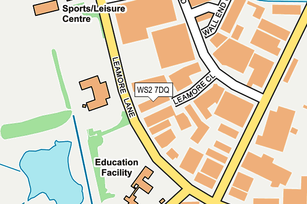
WS2 7DQ lies on Leamore Lane in Walsall. WS2 7DQ is located in the Birchills Leamore electoral ward, within the metropolitan district of Walsall and the English Parliamentary constituency of Walsall North. The Sub Integrated Care Board (ICB) Location is NHS Black Country ICB - D2P2L and the police force is West Midlands. This postcode has been in use since January 1980.


GetTheData
Source: OS OpenMap – Local (Ordnance Survey)
Source: OS VectorMap District (Ordnance Survey)
Licence: Open Government Licence (requires attribution)
| Easting | 399148 |
| Northing | 301078 |
| Latitude | 52.607483 |
| Longitude | -2.014015 |
GetTheData
Source: Open Postcode Geo
Licence: Open Government Licence
| Street | Leamore Lane |
| Town/City | Walsall |
| Country | England |
| Postcode District | WS2 |
➜ See where WS2 is on a map ➜ Where is Bloxwich? | |
GetTheData
Source: Land Registry Price Paid Data
Licence: Open Government Licence
Elevation or altitude of WS2 7DQ as distance above sea level:
| Metres | Feet | |
|---|---|---|
| Elevation | 140m | 459ft |
Elevation is measured from the approximate centre of the postcode, to the nearest point on an OS contour line from OS Terrain 50, which has contour spacing of ten vertical metres.
➜ How high above sea level am I? Find the elevation of your current position using your device's GPS.
GetTheData
Source: Open Postcode Elevation
Licence: Open Government Licence
| Ward | Birchills Leamore |
| Constituency | Walsall North |
GetTheData
Source: ONS Postcode Database
Licence: Open Government Licence
HOLLAND F J AND SONS, LEAMORE LANE, WALSALL, WS2 7DQ 2004 4 JUN £261,500 |
HOLLAND F J AND SONS, LEAMORE LANE, WALSALL, WS2 7DQ 2003 30 MAY £230,000 |
GetTheData
Source: HM Land Registry Price Paid Data
Licence: Contains HM Land Registry data © Crown copyright and database right 2025. This data is licensed under the Open Government Licence v3.0.
| Bloxwich Lane (Leamore Lane) | Beechdale | 92m |
| Industrial Estate (Leamore Lane) | Beechdale | 99m |
| Industrial Estate (Leamore Lane) | Beechdale | 101m |
| Bloxwich Lane (Leamore Lane) | Beechdale | 129m |
| Bloxwich Lane (Stephenson Ave) | Beechdale | 290m |
| Bloxwich Station | 1.2km |
| Bloxwich North Station | 2km |
| Walsall Station | 3.2km |
GetTheData
Source: NaPTAN
Licence: Open Government Licence
GetTheData
Source: ONS Postcode Database
Licence: Open Government Licence


➜ Get more ratings from the Food Standards Agency
GetTheData
Source: Food Standards Agency
Licence: FSA terms & conditions
| Last Collection | |||
|---|---|---|---|
| Location | Mon-Fri | Sat | Distance |
| Dudley Fields | 17:15 | 12:00 | 990m |
| High Street | 17:30 | 12:00 | 1,113m |
| Bloxwich Post Office | 17:30 | 12:15 | 1,170m |
GetTheData
Source: Dracos
Licence: Creative Commons Attribution-ShareAlike
The below table lists the International Territorial Level (ITL) codes (formerly Nomenclature of Territorial Units for Statistics (NUTS) codes) and Local Administrative Units (LAU) codes for WS2 7DQ:
| ITL 1 Code | Name |
|---|---|
| TLG | West Midlands (England) |
| ITL 2 Code | Name |
| TLG3 | West Midlands |
| ITL 3 Code | Name |
| TLG38 | Walsall |
| LAU 1 Code | Name |
| E08000030 | Walsall |
GetTheData
Source: ONS Postcode Directory
Licence: Open Government Licence
The below table lists the Census Output Area (OA), Lower Layer Super Output Area (LSOA), and Middle Layer Super Output Area (MSOA) for WS2 7DQ:
| Code | Name | |
|---|---|---|
| OA | E00051903 | |
| LSOA | E01010273 | Walsall 017C |
| MSOA | E02002126 | Walsall 017 |
GetTheData
Source: ONS Postcode Directory
Licence: Open Government Licence
| WS2 7LZ | Fryers Road | 221m |
| WS2 7JS | Bloxwich Lane | 233m |
| WS2 7DG | Leamore Lane | 258m |
| WS2 7DL | Fleming Place | 330m |
| WS2 7JU | Bloxwich Lane | 338m |
| WS2 7LR | Jenner Close | 340m |
| WS2 7DP | Stephenson Avenue | 374m |
| WS2 7DW | Stephenson Avenue | 388m |
| WS2 7DJ | Fleming Road | 405m |
| WS2 7JR | Bloxwich Lane | 409m |
GetTheData
Source: Open Postcode Geo; Land Registry Price Paid Data
Licence: Open Government Licence