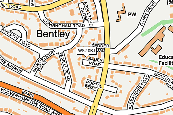
WS2 0BJ lies on Bader Road in Walsall. WS2 0BJ is located in the Bentley and Darlaston North electoral ward, within the metropolitan district of Walsall and the English Parliamentary constituency of Walsall South. The Sub Integrated Care Board (ICB) Location is NHS Black Country ICB - D2P2L and the police force is West Midlands. This postcode has been in use since January 1980.


GetTheData
Source: OS OpenMap – Local (Ordnance Survey)
Source: OS VectorMap District (Ordnance Survey)
Licence: Open Government Licence (requires attribution)
| Easting | 398534 |
| Northing | 298826 |
| Latitude | 52.587236 |
| Longitude | -2.023071 |
GetTheData
Source: Open Postcode Geo
Licence: Open Government Licence
| Street | Bader Road |
| Town/City | Walsall |
| Country | England |
| Postcode District | WS2 |
➜ See where WS2 is on a map ➜ Where is Willenhall? | |
GetTheData
Source: Land Registry Price Paid Data
Licence: Open Government Licence
Elevation or altitude of WS2 0BJ as distance above sea level:
| Metres | Feet | |
|---|---|---|
| Elevation | 140m | 459ft |
Elevation is measured from the approximate centre of the postcode, to the nearest point on an OS contour line from OS Terrain 50, which has contour spacing of ten vertical metres.
➜ How high above sea level am I? Find the elevation of your current position using your device's GPS.
GetTheData
Source: Open Postcode Elevation
Licence: Open Government Licence
| Ward | Bentley And Darlaston North |
| Constituency | Walsall South |
GetTheData
Source: ONS Postcode Database
Licence: Open Government Licence
| Cairn Drive (Queen Elizabeth Ave) | Bentley | 69m |
| Cairn Drive (Queen Elizabeth Ave) | Bentley | 88m |
| Morris Avenue (Queen Elizabeth Ave) | County Bridge | 136m |
| Morris Ave (Queen Elizabeth Ave) | County Bridge | 151m |
| Churchill Rd (Queen Elizabeth Ave) | Bentley | 208m |
| Walsall Station | 2.6km |
| Bescot Stadium Station | 3.5km |
| Bloxwich Station | 3.5km |
GetTheData
Source: NaPTAN
Licence: Open Government Licence
| Percentage of properties with Next Generation Access | 100.0% |
| Percentage of properties with Superfast Broadband | 100.0% |
| Percentage of properties with Ultrafast Broadband | 100.0% |
| Percentage of properties with Full Fibre Broadband | 0.0% |
Superfast Broadband is between 30Mbps and 300Mbps
Ultrafast Broadband is > 300Mbps
| Median download speed | 100.0Mbps |
| Average download speed | 115.5Mbps |
| Maximum download speed | 350.00Mbps |
| Median upload speed | 10.0Mbps |
| Average upload speed | 12.4Mbps |
| Maximum upload speed | 19.53Mbps |
| Percentage of properties unable to receive 2Mbps | 0.0% |
| Percentage of properties unable to receive 5Mbps | 0.0% |
| Percentage of properties unable to receive 10Mbps | 0.0% |
| Percentage of properties unable to receive 30Mbps | 0.0% |
GetTheData
Source: Ofcom
Licence: Ofcom Terms of Use (requires attribution)
Estimated total energy consumption in WS2 0BJ by fuel type, 2015.
| Consumption (kWh) | 186,913 |
|---|---|
| Meter count | 16 |
| Mean (kWh/meter) | 11,682 |
| Median (kWh/meter) | 11,261 |
| Consumption (kWh) | 60,195 |
|---|---|
| Meter count | 14 |
| Mean (kWh/meter) | 4,300 |
| Median (kWh/meter) | 3,389 |
GetTheData
Source: Postcode level gas estimates: 2015 (experimental)
Source: Postcode level electricity estimates: 2015 (experimental)
Licence: Open Government Licence
GetTheData
Source: ONS Postcode Database
Licence: Open Government Licence


➜ Get more ratings from the Food Standards Agency
GetTheData
Source: Food Standards Agency
Licence: FSA terms & conditions
| Last Collection | |||
|---|---|---|---|
| Location | Mon-Fri | Sat | Distance |
| Queen Elizabeth Avenue | 17:15 | 12:00 | 224m |
| Morris Avenue | 17:15 | 12:00 | 366m |
| Attlee Road | 17:15 | 12:00 | 588m |
GetTheData
Source: Dracos
Licence: Creative Commons Attribution-ShareAlike
The below table lists the International Territorial Level (ITL) codes (formerly Nomenclature of Territorial Units for Statistics (NUTS) codes) and Local Administrative Units (LAU) codes for WS2 0BJ:
| ITL 1 Code | Name |
|---|---|
| TLG | West Midlands (England) |
| ITL 2 Code | Name |
| TLG3 | West Midlands |
| ITL 3 Code | Name |
| TLG38 | Walsall |
| LAU 1 Code | Name |
| E08000030 | Walsall |
GetTheData
Source: ONS Postcode Directory
Licence: Open Government Licence
The below table lists the Census Output Area (OA), Lower Layer Super Output Area (LSOA), and Middle Layer Super Output Area (MSOA) for WS2 0BJ:
| Code | Name | |
|---|---|---|
| OA | E00051869 | |
| LSOA | E01010260 | Walsall 023C |
| MSOA | E02002132 | Walsall 023 |
GetTheData
Source: ONS Postcode Directory
Licence: Open Government Licence
| WS2 0BG | Queen Elizabeth Avenue | 45m |
| WS2 0BH | Tedder Road | 49m |
| WS2 0BL | Portal Road | 77m |
| WS2 0AX | Montgomery Road | 86m |
| WS2 0EF | Wavell Road | 99m |
| WS2 0HG | Queen Elizabeth Avenue | 103m |
| WS2 0HW | Cairn Drive | 145m |
| WS2 0AY | Cunningham Road | 150m |
| WS2 0AU | Montgomery Road | 161m |
| WS2 0HL | Mountbatten Road | 163m |
GetTheData
Source: Open Postcode Geo; Land Registry Price Paid Data
Licence: Open Government Licence