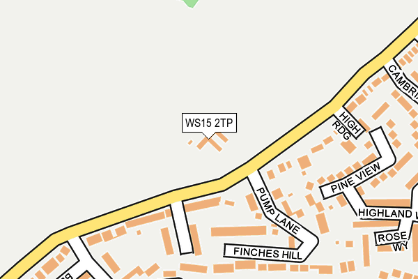
WS15 2TP lies on Bower Lane in Rugeley. WS15 2TP is located in the Haywood & Hixon electoral ward, within the local authority district of Stafford and the English Parliamentary constituency of Stafford. The Sub Integrated Care Board (ICB) Location is NHS Staffordshire and Stoke-on-Trent ICB - 05V and the police force is Staffordshire. This postcode has been in use since January 1980.


GetTheData
Source: OS OpenMap – Local (Ordnance Survey)
Source: OS VectorMap District (Ordnance Survey)
Licence: Open Government Licence (requires attribution)
| Easting | 403049 |
| Northing | 319123 |
| Latitude | 52.769693 |
| Longitude | -1.956249 |
GetTheData
Source: Open Postcode Geo
Licence: Open Government Licence
| Street | Bower Lane |
| Town/City | Rugeley |
| Country | England |
| Postcode District | WS15 |
➜ See where WS15 is on a map ➜ Where is Rugeley? | |
GetTheData
Source: Land Registry Price Paid Data
Licence: Open Government Licence
Elevation or altitude of WS15 2TP as distance above sea level:
| Metres | Feet | |
|---|---|---|
| Elevation | 100m | 328ft |
Elevation is measured from the approximate centre of the postcode, to the nearest point on an OS contour line from OS Terrain 50, which has contour spacing of ten vertical metres.
➜ How high above sea level am I? Find the elevation of your current position using your device's GPS.
GetTheData
Source: Open Postcode Elevation
Licence: Open Government Licence
| Ward | Haywood & Hixon |
| Constituency | Stafford |
GetTheData
Source: ONS Postcode Database
Licence: Open Government Licence
| Pump Lane (Bower Lane) | Springfields | 67m |
| Pump Lane (Bower Lane) | Springfields | 70m |
| Crestwood Rise (Bower Lane) | Springfields | 120m |
| Crestwood Rise (Bower Lane) | Rugeley | 150m |
| Antler Drive (Penk Drive North) | Springfields | 241m |
| Rugeley Trent Valley Station | 1.8km |
| Rugeley Town Station | 2.1km |
GetTheData
Source: NaPTAN
Licence: Open Government Licence
| Percentage of properties with Next Generation Access | 100.0% |
| Percentage of properties with Superfast Broadband | 100.0% |
| Percentage of properties with Ultrafast Broadband | 25.0% |
| Percentage of properties with Full Fibre Broadband | 0.0% |
Superfast Broadband is between 30Mbps and 300Mbps
Ultrafast Broadband is > 300Mbps
| Percentage of properties unable to receive 2Mbps | 0.0% |
| Percentage of properties unable to receive 5Mbps | 0.0% |
| Percentage of properties unable to receive 10Mbps | 0.0% |
| Percentage of properties unable to receive 30Mbps | 0.0% |
GetTheData
Source: Ofcom
Licence: Ofcom Terms of Use (requires attribution)
GetTheData
Source: ONS Postcode Database
Licence: Open Government Licence


➜ Get more ratings from the Food Standards Agency
GetTheData
Source: Food Standards Agency
Licence: FSA terms & conditions
| Last Collection | |||
|---|---|---|---|
| Location | Mon-Fri | Sat | Distance |
| Armitage Road | 17:30 | 07:30 | 1,678m |
| Rugeley Post Office | 18:00 | 11:00 | 1,851m |
| Wolseley Bridge Post Office | 16:45 | 11:30 | 2,083m |
GetTheData
Source: Dracos
Licence: Creative Commons Attribution-ShareAlike
The below table lists the International Territorial Level (ITL) codes (formerly Nomenclature of Territorial Units for Statistics (NUTS) codes) and Local Administrative Units (LAU) codes for WS15 2TP:
| ITL 1 Code | Name |
|---|---|
| TLG | West Midlands (England) |
| ITL 2 Code | Name |
| TLG2 | Shropshire and Staffordshire |
| ITL 3 Code | Name |
| TLG24 | Staffordshire CC |
| LAU 1 Code | Name |
| E07000197 | Stafford |
GetTheData
Source: ONS Postcode Directory
Licence: Open Government Licence
The below table lists the Census Output Area (OA), Lower Layer Super Output Area (LSOA), and Middle Layer Super Output Area (MSOA) for WS15 2TP:
| Code | Name | |
|---|---|---|
| OA | E00151388 | |
| LSOA | E01029711 | Stafford 008C |
| MSOA | E02006195 | Stafford 008 |
GetTheData
Source: ONS Postcode Directory
Licence: Open Government Licence
| WS15 2TS | Bower Lane | 139m |
| WS15 2XZ | Crestwood Rise | 155m |
| WS15 2TW | Pump Lane | 169m |
| WS15 2TR | Bower Lane | 186m |
| WS15 2TN | Finches Hill | 202m |
| WS15 2XW | Pine View | 204m |
| WS15 2XU | Canaway Walk | 232m |
| WS15 2XS | Antler Drive | 241m |
| WS15 2XJ | Highland Way | 255m |
| WS15 2XP | Spruce Walk | 262m |
GetTheData
Source: Open Postcode Geo; Land Registry Price Paid Data
Licence: Open Government Licence