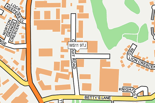
WS11 9TJ lies on Conduit Road in Norton Canes, Cannock. WS11 9TJ is located in the Norton Canes electoral ward, within the local authority district of Cannock Chase and the English Parliamentary constituency of Cannock Chase. The Sub Integrated Care Board (ICB) Location is NHS Staffordshire and Stoke-on-Trent ICB - 04Y and the police force is Staffordshire. This postcode has been in use since March 2003.


GetTheData
Source: OS OpenMap – Local (Ordnance Survey)
Source: OS VectorMap District (Ordnance Survey)
Licence: Open Government Licence (requires attribution)
| Easting | 402042 |
| Northing | 307809 |
| Latitude | 52.668006 |
| Longitude | -1.971234 |
GetTheData
Source: Open Postcode Geo
Licence: Open Government Licence
| Street | Conduit Road |
| Locality | Norton Canes |
| Town/City | Cannock |
| Country | England |
| Postcode District | WS11 |
➜ See where WS11 is on a map ➜ Where is Norton Canes? | |
GetTheData
Source: Land Registry Price Paid Data
Licence: Open Government Licence
Elevation or altitude of WS11 9TJ as distance above sea level:
| Metres | Feet | |
|---|---|---|
| Elevation | 150m | 492ft |
Elevation is measured from the approximate centre of the postcode, to the nearest point on an OS contour line from OS Terrain 50, which has contour spacing of ten vertical metres.
➜ How high above sea level am I? Find the elevation of your current position using your device's GPS.
GetTheData
Source: Open Postcode Elevation
Licence: Open Government Licence
| Ward | Norton Canes |
| Constituency | Cannock Chase |
GetTheData
Source: ONS Postcode Database
Licence: Open Government Licence
| Lock Keepers Close (Walsall Rd) | Norton Canes | 218m |
| Lock Keepers Close (Walsall Road) | Norton Canes | 224m |
| Norton Canes Business Park (Norton Green Lane) | Norton Canes | 270m |
| Norton Canes Business Park (Norton Green Lane) | Norton Canes | 276m |
| The Brambles (Jerome Road) | Norton Canes | 434m |
| Landywood Station | 3.6km |
| Cannock Station | 4km |
| Hednesford Station | 5.1km |
GetTheData
Source: NaPTAN
Licence: Open Government Licence
| Median download speed | 34.2Mbps |
| Average download speed | 39.0Mbps |
| Maximum download speed | 80.00Mbps |
| Median upload speed | 6.8Mbps |
| Average upload speed | 8.5Mbps |
| Maximum upload speed | 20.00Mbps |
GetTheData
Source: Ofcom
Licence: Ofcom Terms of Use (requires attribution)
Estimated total energy consumption in WS11 9TJ by fuel type, 2015.
| Consumption (kWh) | 124,943 |
|---|---|
| Meter count | 8 |
| Mean (kWh/meter) | 15,618 |
| Median (kWh/meter) | 18,586 |
GetTheData
Source: Postcode level gas estimates: 2015 (experimental)
Source: Postcode level electricity estimates: 2015 (experimental)
Licence: Open Government Licence
GetTheData
Source: ONS Postcode Database
Licence: Open Government Licence


➜ Get more ratings from the Food Standards Agency
GetTheData
Source: Food Standards Agency
Licence: FSA terms & conditions
| Last Collection | |||
|---|---|---|---|
| Location | Mon-Fri | Sat | Distance |
| Asda | 17:30 | 11:15 | 216m |
| Walsall Road | 18:00 | 10:45 | 313m |
| Toll Road Services Bettys Lane | 15:45 | 10:15 | 453m |
GetTheData
Source: Dracos
Licence: Creative Commons Attribution-ShareAlike
The below table lists the International Territorial Level (ITL) codes (formerly Nomenclature of Territorial Units for Statistics (NUTS) codes) and Local Administrative Units (LAU) codes for WS11 9TJ:
| ITL 1 Code | Name |
|---|---|
| TLG | West Midlands (England) |
| ITL 2 Code | Name |
| TLG2 | Shropshire and Staffordshire |
| ITL 3 Code | Name |
| TLG24 | Staffordshire CC |
| LAU 1 Code | Name |
| E07000192 | Cannock Chase |
GetTheData
Source: ONS Postcode Directory
Licence: Open Government Licence
The below table lists the Census Output Area (OA), Lower Layer Super Output Area (LSOA), and Middle Layer Super Output Area (MSOA) for WS11 9TJ:
| Code | Name | |
|---|---|---|
| OA | E00149786 | |
| LSOA | E01029397 | Cannock Chase 013D |
| MSOA | E02006130 | Cannock Chase 013 |
GetTheData
Source: ONS Postcode Directory
Licence: Open Government Licence
| WS11 9TA | Walsall Road | 200m |
| WS11 9QS | Red Lion Crescent | 217m |
| WS11 9PX | Walsall Road | 224m |
| WS11 9RA | Norton Grange Crescent | 252m |
| WS11 9PT | Bettys Lane | 257m |
| WS11 9QY | Walsall Road | 264m |
| WS11 9NP | Bettys Lane | 299m |
| WS11 9UN | Lock Keepers Close | 307m |
| WS11 9FW | Quinton Place | 314m |
| WS11 9QR | Red Lion Avenue | 320m |
GetTheData
Source: Open Postcode Geo; Land Registry Price Paid Data
Licence: Open Government Licence