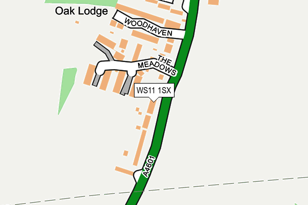
WS11 1SX lies on Wolverhampton Road in Wedges Mills, Cannock. WS11 1SX is located in the Featherstone, Sharehill & Saredon electoral ward, within the local authority district of South Staffordshire and the English Parliamentary constituency of South Staffordshire. The Sub Integrated Care Board (ICB) Location is NHS Staffordshire and Stoke-on-Trent ICB - 04Y and the police force is Staffordshire. This postcode has been in use since January 1980.


GetTheData
Source: OS OpenMap – Local (Ordnance Survey)
Source: OS VectorMap District (Ordnance Survey)
Licence: Open Government Licence (requires attribution)
| Easting | 396624 |
| Northing | 308319 |
| Latitude | 52.672567 |
| Longitude | -2.051363 |
GetTheData
Source: Open Postcode Geo
Licence: Open Government Licence
| Street | Wolverhampton Road |
| Locality | Wedges Mills |
| Town/City | Cannock |
| Country | England |
| Postcode District | WS11 |
➜ See where WS11 is on a map | |
GetTheData
Source: Land Registry Price Paid Data
Licence: Open Government Licence
Elevation or altitude of WS11 1SX as distance above sea level:
| Metres | Feet | |
|---|---|---|
| Elevation | 130m | 427ft |
Elevation is measured from the approximate centre of the postcode, to the nearest point on an OS contour line from OS Terrain 50, which has contour spacing of ten vertical metres.
➜ How high above sea level am I? Find the elevation of your current position using your device's GPS.
GetTheData
Source: Open Postcode Elevation
Licence: Open Government Licence
| Ward | Featherstone, Sharehill & Saredon |
| Constituency | South Staffordshire |
GetTheData
Source: ONS Postcode Database
Licence: Open Government Licence
| Woodhaven (Wolverhampton Road) | Wedge's Mills | 26m |
| Woodhaven (Wolverhampton Rd) | Wedge's Mills | 37m |
| Saredon Road (Wolverhampton Road) | Wedge's Mills | 326m |
| Playing Field (Wolverhampton Rd) | Wedge's Mills | 373m |
| Playing Field (Wolverhampton Rd) | Wedge's Mills | 380m |
| Cannock Station | 2.5km |
| Landywood Station | 2.7km |
| Hednesford Station | 5.4km |
GetTheData
Source: NaPTAN
Licence: Open Government Licence
| Percentage of properties with Next Generation Access | 100.0% |
| Percentage of properties with Superfast Broadband | 100.0% |
| Percentage of properties with Ultrafast Broadband | 0.0% |
| Percentage of properties with Full Fibre Broadband | 0.0% |
Superfast Broadband is between 30Mbps and 300Mbps
Ultrafast Broadband is > 300Mbps
| Median download speed | 39.1Mbps |
| Average download speed | 30.3Mbps |
| Maximum download speed | 68.09Mbps |
| Median upload speed | 7.1Mbps |
| Average upload speed | 5.7Mbps |
| Maximum upload speed | 10.72Mbps |
| Percentage of properties unable to receive 2Mbps | 0.0% |
| Percentage of properties unable to receive 5Mbps | 0.0% |
| Percentage of properties unable to receive 10Mbps | 0.0% |
| Percentage of properties unable to receive 30Mbps | 0.0% |
GetTheData
Source: Ofcom
Licence: Ofcom Terms of Use (requires attribution)
Estimated total energy consumption in WS11 1SX by fuel type, 2015.
| Consumption (kWh) | 480,124 |
|---|---|
| Meter count | 36 |
| Mean (kWh/meter) | 13,337 |
| Median (kWh/meter) | 12,173 |
| Consumption (kWh) | 118,059 |
|---|---|
| Meter count | 33 |
| Mean (kWh/meter) | 3,578 |
| Median (kWh/meter) | 3,370 |
GetTheData
Source: Postcode level gas estimates: 2015 (experimental)
Source: Postcode level electricity estimates: 2015 (experimental)
Licence: Open Government Licence
GetTheData
Source: ONS Postcode Database
Licence: Open Government Licence


➜ Get more ratings from the Food Standards Agency
GetTheData
Source: Food Standards Agency
Licence: FSA terms & conditions
| Last Collection | |||
|---|---|---|---|
| Location | Mon-Fri | Sat | Distance |
| Anson Road | 16:00 | 10:00 | 564m |
| Kestrel Way | 16:15 | 10:15 | 1,721m |
| High Street | 16:45 | 10:30 | 1,725m |
GetTheData
Source: Dracos
Licence: Creative Commons Attribution-ShareAlike
The below table lists the International Territorial Level (ITL) codes (formerly Nomenclature of Territorial Units for Statistics (NUTS) codes) and Local Administrative Units (LAU) codes for WS11 1SX:
| ITL 1 Code | Name |
|---|---|
| TLG | West Midlands (England) |
| ITL 2 Code | Name |
| TLG2 | Shropshire and Staffordshire |
| ITL 3 Code | Name |
| TLG24 | Staffordshire CC |
| LAU 1 Code | Name |
| E07000196 | South Staffordshire |
GetTheData
Source: ONS Postcode Directory
Licence: Open Government Licence
The below table lists the Census Output Area (OA), Lower Layer Super Output Area (LSOA), and Middle Layer Super Output Area (MSOA) for WS11 1SX:
| Code | Name | |
|---|---|---|
| OA | E00150939 | |
| LSOA | E01029621 | South Staffordshire 002A |
| MSOA | E02006175 | South Staffordshire 002 |
GetTheData
Source: ONS Postcode Directory
Licence: Open Government Licence
| WS11 1RB | The Meadows | 108m |
| WS11 1RE | Woodhaven | 170m |
| WS11 1TB | Hall Meadow | 225m |
| WS11 1SU | Wolverhampton Road | 358m |
| WS11 1TA | Wood Lane | 414m |
| WS11 1SZ | Wood Lane | 429m |
| WS11 0LT | Lodge Lane | 449m |
| WS11 1ST | Wolverhampton Road | 460m |
| WV10 7LS | 618m | |
| WV10 7LT | Wolverhampton Road | 649m |
GetTheData
Source: Open Postcode Geo; Land Registry Price Paid Data
Licence: Open Government Licence