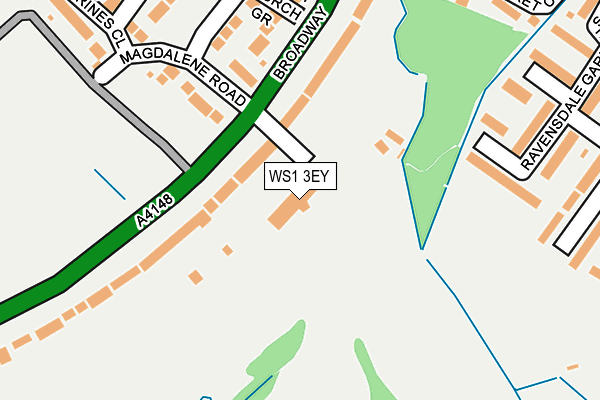
WS1 3EY is located in the Palfrey electoral ward, within the metropolitan district of Walsall and the English Parliamentary constituency of Walsall South. The Sub Integrated Care Board (ICB) Location is NHS Black Country ICB - D2P2L and the police force is West Midlands. This postcode has been in use since January 1980.


GetTheData
Source: OS OpenMap – Local (Ordnance Survey)
Source: OS VectorMap District (Ordnance Survey)
Licence: Open Government Licence (requires attribution)
| Easting | 402492 |
| Northing | 296892 |
| Latitude | 52.569847 |
| Longitude | -1.964665 |
GetTheData
Source: Open Postcode Geo
Licence: Open Government Licence
| Country | England |
| Postcode District | WS1 |
➜ See where WS1 is on a map ➜ Where is Walsall? | |
GetTheData
Source: Land Registry Price Paid Data
Licence: Open Government Licence
Elevation or altitude of WS1 3EY as distance above sea level:
| Metres | Feet | |
|---|---|---|
| Elevation | 120m | 394ft |
Elevation is measured from the approximate centre of the postcode, to the nearest point on an OS contour line from OS Terrain 50, which has contour spacing of ten vertical metres.
➜ How high above sea level am I? Find the elevation of your current position using your device's GPS.
GetTheData
Source: Open Postcode Elevation
Licence: Open Government Licence
| Ward | Palfrey |
| Constituency | Walsall South |
GetTheData
Source: ONS Postcode Database
Licence: Open Government Licence
| Gorway Farm (Broadway) | Delves | 90m |
| Gorway Farm (Broadway) | Delves | 105m |
| Birmingham Rd (Broadway) | Delves | 352m |
| Travelodge (Birmingham Rd) | Delves | 377m |
| Travelodge (Birmingham Rd) | Delves | 383m |
| Bescot Stadium Station | 1.9km |
| Tame Bridge Parkway Station | 2km |
| Walsall Station | 2.1km |
GetTheData
Source: NaPTAN
Licence: Open Government Licence
GetTheData
Source: ONS Postcode Database
Licence: Open Government Licence


➜ Get more ratings from the Food Standards Agency
GetTheData
Source: Food Standards Agency
Licence: FSA terms & conditions
| Last Collection | |||
|---|---|---|---|
| Location | Mon-Fri | Sat | Distance |
| Delves Green Road | 17:15 | 12:00 | 432m |
| Darwall Street | 19:00 | 13:00 | 538m |
| Gorway Road | 17:45 | 12:00 | 608m |
GetTheData
Source: Dracos
Licence: Creative Commons Attribution-ShareAlike
The below table lists the International Territorial Level (ITL) codes (formerly Nomenclature of Territorial Units for Statistics (NUTS) codes) and Local Administrative Units (LAU) codes for WS1 3EY:
| ITL 1 Code | Name |
|---|---|
| TLG | West Midlands (England) |
| ITL 2 Code | Name |
| TLG3 | West Midlands |
| ITL 3 Code | Name |
| TLG38 | Walsall |
| LAU 1 Code | Name |
| E08000030 | Walsall |
GetTheData
Source: ONS Postcode Directory
Licence: Open Government Licence
The below table lists the Census Output Area (OA), Lower Layer Super Output Area (LSOA), and Middle Layer Super Output Area (MSOA) for WS1 3EY:
| Code | Name | |
|---|---|---|
| OA | E00052235 | |
| LSOA | E01010339 | Walsall 037D |
| MSOA | E02002146 | Walsall 037 |
GetTheData
Source: ONS Postcode Directory
Licence: Open Government Licence
| WS1 3EX | Broadway | 150m |
| WS1 3TA | Magdalene Road | 185m |
| WS1 3TD | Christ Church Grove | 205m |
| WS1 3EZ | Broadway | 218m |
| WS5 3PX | Ravensdale Gardens | 265m |
| WS1 3TB | Keble Grove | 274m |
| WS5 3PY | Ravensdale Close | 280m |
| WS1 3TF | New College Close | 301m |
| WS1 3TE | St Catharines Close | 305m |
| WS5 3PU | Cricket Close | 308m |
GetTheData
Source: Open Postcode Geo; Land Registry Price Paid Data
Licence: Open Government Licence