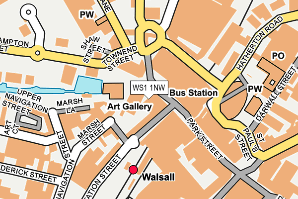
WS1 1NW lies on Park Street in Walsall. WS1 1NW is located in the St Matthew's electoral ward, within the metropolitan district of Walsall and the English Parliamentary constituency of Walsall South. The Sub Integrated Care Board (ICB) Location is NHS Black Country ICB - D2P2L and the police force is West Midlands. This postcode has been in use since December 1996.


GetTheData
Source: OS OpenMap – Local (Ordnance Survey)
Source: OS VectorMap District (Ordnance Survey)
Licence: Open Government Licence (requires attribution)
| Easting | 401122 |
| Northing | 298625 |
| Latitude | 52.585431 |
| Longitude | -1.984873 |
GetTheData
Source: Open Postcode Geo
Licence: Open Government Licence
| Street | Park Street |
| Town/City | Walsall |
| Country | England |
| Postcode District | WS1 |
➜ See where WS1 is on a map ➜ Where is Walsall? | |
GetTheData
Source: Land Registry Price Paid Data
Licence: Open Government Licence
Elevation or altitude of WS1 1NW as distance above sea level:
| Metres | Feet | |
|---|---|---|
| Elevation | 120m | 394ft |
Elevation is measured from the approximate centre of the postcode, to the nearest point on an OS contour line from OS Terrain 50, which has contour spacing of ten vertical metres.
➜ How high above sea level am I? Find the elevation of your current position using your device's GPS.
GetTheData
Source: Open Postcode Elevation
Licence: Open Government Licence
| Ward | St Matthew's |
| Constituency | Walsall South |
GetTheData
Source: ONS Postcode Database
Licence: Open Government Licence
| Tesco (St Pauls St) | Walsall | 104m |
| The Wharf (Wolverhampton Street) | Walsall | 177m |
| The Wharf (Wolverhampton Street) | Walsall | 178m |
| Council Car Park (Green Lane) | Walsall | 191m |
| Hatherton Rd | Walsall | 195m |
| Walsall Station | 0.1km |
| Bescot Stadium Station | 2.5km |
| Tame Bridge Parkway Station | 3.7km |
GetTheData
Source: NaPTAN
Licence: Open Government Licence
GetTheData
Source: ONS Postcode Database
Licence: Open Government Licence

➜ Get more ratings from the Food Standards Agency
GetTheData
Source: Food Standards Agency
Licence: FSA terms & conditions
| Last Collection | |||
|---|---|---|---|
| Location | Mon-Fri | Sat | Distance |
| Lime Lane | 18:00 | 11:15 | 251m |
| Bridge Street | 18:30 | 12:30 | 379m |
| Stafford Street | 17:15 | 12:00 | 546m |
GetTheData
Source: Dracos
Licence: Creative Commons Attribution-ShareAlike
The below table lists the International Territorial Level (ITL) codes (formerly Nomenclature of Territorial Units for Statistics (NUTS) codes) and Local Administrative Units (LAU) codes for WS1 1NW:
| ITL 1 Code | Name |
|---|---|
| TLG | West Midlands (England) |
| ITL 2 Code | Name |
| TLG3 | West Midlands |
| ITL 3 Code | Name |
| TLG38 | Walsall |
| LAU 1 Code | Name |
| E08000030 | Walsall |
GetTheData
Source: ONS Postcode Directory
Licence: Open Government Licence
The below table lists the Census Output Area (OA), Lower Layer Super Output Area (LSOA), and Middle Layer Super Output Area (MSOA) for WS1 1NW:
| Code | Name | |
|---|---|---|
| OA | E00052348 | |
| LSOA | E01010363 | Walsall 026D |
| MSOA | E02002135 | Walsall 026 |
GetTheData
Source: ONS Postcode Directory
Licence: Open Government Licence
| WS2 9JY | Station Street | 60m |
| WS2 9JT | Little Station Street | 66m |
| WS2 8LN | Gallery Square | 80m |
| WS2 9JR | Little Station Street | 103m |
| WS2 9LB | Marsh Street | 104m |
| WS1 1NG | Park Street | 118m |
| WS1 1YS | Park Mall | 119m |
| WS2 9JZ | Station Street | 150m |
| WS1 1LY | Park Street | 151m |
| WS2 8DF | Stafford Street | 211m |
GetTheData
Source: Open Postcode Geo; Land Registry Price Paid Data
Licence: Open Government Licence