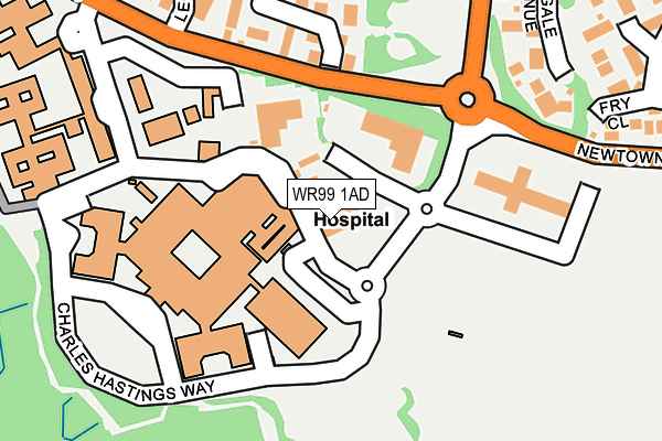
WR99 1AD is located in the Warndon Parish South electoral ward, within the local authority district of Worcester and the English Parliamentary constituency of Worcester. The Sub Integrated Care Board (ICB) Location is NHS Herefordshire and Worcestershire ICB - 18C and the police force is West Mercia. This postcode has been in use since November 2002.


GetTheData
Source: OS OpenMap – Local (Ordnance Survey)
Source: OS VectorMap District (Ordnance Survey)
Licence: Open Government Licence (requires attribution)
| Easting | 387857 |
| Northing | 254838 |
| Latitude | 52.191646 |
| Longitude | -2.179053 |
GetTheData
Source: Open Postcode Geo
Licence: Open Government Licence
| Country | England |
| Postcode District | WR99 |
➜ Where is Worcester? | |
GetTheData
Source: Land Registry Price Paid Data
Licence: Open Government Licence
Elevation or altitude of WR99 1AD as distance above sea level:
| Metres | Feet | |
|---|---|---|
| Elevation | 70m | 230ft |
Elevation is measured from the approximate centre of the postcode, to the nearest point on an OS contour line from OS Terrain 50, which has contour spacing of ten vertical metres.
➜ How high above sea level am I? Find the elevation of your current position using your device's GPS.
GetTheData
Source: Open Postcode Elevation
Licence: Open Government Licence
| Ward | Warndon Parish South |
| Constituency | Worcester |
GetTheData
Source: ONS Postcode Database
Licence: Open Government Licence
| A & E Unit (Charles Hastings Way) | Worcestershire Royal Hospital | 32m |
| Oaklands (Newtown Road (B4636)) | Worcestershire Royal Hospital | 142m |
| Main Entrance (Worcestershire Royal Hospital) | Worcestershire Royal Hospital | 191m |
| Oaklands (Newtown Road) | Worcestershire Royal Hospital | 193m |
| Childrens Unit (Charles Hastings Way) | Worcestershire Royal Hospital | 243m |
| Worcester Shrub Hill Station | 2.1km |
| Worcester Foregate Street Station | 2.9km |
GetTheData
Source: NaPTAN
Licence: Open Government Licence
GetTheData
Source: ONS Postcode Database
Licence: Open Government Licence


➜ Get more ratings from the Food Standards Agency
GetTheData
Source: Food Standards Agency
Licence: FSA terms & conditions
| Last Collection | |||
|---|---|---|---|
| Location | Mon-Fri | Sat | Distance |
| Canterbury Road | 17:15 | 11:30 | 616m |
| Dugdale Drive | 17:00 | 11:30 | 640m |
| Newtown P.o. | 17:30 | 12:30 | 763m |
GetTheData
Source: Dracos
Licence: Creative Commons Attribution-ShareAlike
The below table lists the International Territorial Level (ITL) codes (formerly Nomenclature of Territorial Units for Statistics (NUTS) codes) and Local Administrative Units (LAU) codes for WR99 1AD:
| ITL 1 Code | Name |
|---|---|
| TLG | West Midlands (England) |
| ITL 2 Code | Name |
| TLG1 | Herefordshire, Worcestershire and Warwickshire |
| ITL 3 Code | Name |
| TLG12 | Worcestershire CC |
| LAU 1 Code | Name |
| E07000237 | Worcester |
GetTheData
Source: ONS Postcode Directory
Licence: Open Government Licence
The below table lists the Census Output Area (OA), Lower Layer Super Output Area (LSOA), and Middle Layer Super Output Area (MSOA) for WR99 1AD:
| Code | Name | |
|---|---|---|
| OA | E00164946 | |
| LSOA | E01032339 | Worcester 008C |
| MSOA | E02006741 | Worcester 008 |
GetTheData
Source: ONS Postcode Directory
Licence: Open Government Licence
| WR5 1JR | Kings Court Business Park | 99m |
| WR5 1SL | Oaklands | 200m |
| WR5 1JW | Leopard Rise | 249m |
| WR4 0LZ | Nightingale Avenue | 251m |
| WR4 0SD | Fry Close | 281m |
| WR5 1JN | The Heights | 295m |
| WR4 0NJ | Wilberforce Place | 331m |
| WR5 1SQ | Bramble Gardens | 334m |
| WR4 0NW | Amos Gardens | 354m |
| WR4 0LN | Fels Avenue | 361m |
GetTheData
Source: Open Postcode Geo; Land Registry Price Paid Data
Licence: Open Government Licence