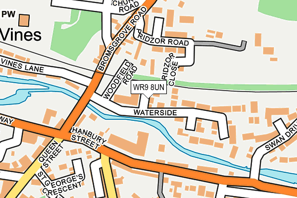
WR9 8UN lies on Waterside Close in Droitwich. WR9 8UN is located in the Droitwich East electoral ward, within the local authority district of Wychavon and the English Parliamentary constituency of Mid Worcestershire. The Sub Integrated Care Board (ICB) Location is NHS Herefordshire and Worcestershire ICB - 18C and the police force is West Mercia. This postcode has been in use since July 1990.


GetTheData
Source: OS OpenMap – Local (Ordnance Survey)
Source: OS VectorMap District (Ordnance Survey)
Licence: Open Government Licence (requires attribution)
| Easting | 390403 |
| Northing | 263495 |
| Latitude | 52.269526 |
| Longitude | -2.142058 |
GetTheData
Source: Open Postcode Geo
Licence: Open Government Licence
| Street | Waterside Close |
| Town/City | Droitwich |
| Country | England |
| Postcode District | WR9 |
➜ See where WR9 is on a map ➜ Where is Droitwich Spa? | |
GetTheData
Source: Land Registry Price Paid Data
Licence: Open Government Licence
Elevation or altitude of WR9 8UN as distance above sea level:
| Metres | Feet | |
|---|---|---|
| Elevation | 30m | 98ft |
Elevation is measured from the approximate centre of the postcode, to the nearest point on an OS contour line from OS Terrain 50, which has contour spacing of ten vertical metres.
➜ How high above sea level am I? Find the elevation of your current position using your device's GPS.
GetTheData
Source: Open Postcode Elevation
Licence: Open Government Licence
| Ward | Droitwich East |
| Constituency | Mid Worcestershire |
GetTheData
Source: ONS Postcode Database
Licence: Open Government Licence
2023 28 APR £335,000 |
10, WATERSIDE CLOSE, DROITWICH, WR9 8UN 2002 9 JAN £112,000 |
8, WATERSIDE CLOSE, DROITWICH, WR9 8UN 1998 7 DEC £89,000 |
1996 9 DEC £74,500 |
8, WATERSIDE CLOSE, DROITWICH, WR9 8UN 1996 24 MAY £67,000 |
1995 21 FEB £73,000 |
GetTheData
Source: HM Land Registry Price Paid Data
Licence: Contains HM Land Registry data © Crown copyright and database right 2025. This data is licensed under the Open Government Licence v3.0.
| Dodderhill Road (Bromsgrove Road) | Hill End | 219m |
| Dodderhill Road (Bromsgrove Road) | Hill End | 247m |
| Queen Street | Droitwich Spa | 285m |
| Waitrose (Saltway) | Droitwich Spa | 315m |
| Ludlow House (The Holloway) | Droitwich Spa | 334m |
| Droitwich Spa Station | 1.1km |
GetTheData
Source: NaPTAN
Licence: Open Government Licence
| Percentage of properties with Next Generation Access | 100.0% |
| Percentage of properties with Superfast Broadband | 100.0% |
| Percentage of properties with Ultrafast Broadband | 0.0% |
| Percentage of properties with Full Fibre Broadband | 0.0% |
Superfast Broadband is between 30Mbps and 300Mbps
Ultrafast Broadband is > 300Mbps
| Percentage of properties unable to receive 2Mbps | 0.0% |
| Percentage of properties unable to receive 5Mbps | 0.0% |
| Percentage of properties unable to receive 10Mbps | 0.0% |
| Percentage of properties unable to receive 30Mbps | 0.0% |
GetTheData
Source: Ofcom
Licence: Ofcom Terms of Use (requires attribution)
GetTheData
Source: ONS Postcode Database
Licence: Open Government Licence


➜ Get more ratings from the Food Standards Agency
GetTheData
Source: Food Standards Agency
Licence: FSA terms & conditions
| Last Collection | |||
|---|---|---|---|
| Location | Mon-Fri | Sat | Distance |
| Woodfield Road | 16:45 | 09:30 | 154m |
| Hanbury Street | 16:45 | 10:30 | 170m |
| Vines Lane | 16:45 | 09:30 | 348m |
GetTheData
Source: Dracos
Licence: Creative Commons Attribution-ShareAlike
The below table lists the International Territorial Level (ITL) codes (formerly Nomenclature of Territorial Units for Statistics (NUTS) codes) and Local Administrative Units (LAU) codes for WR9 8UN:
| ITL 1 Code | Name |
|---|---|
| TLG | West Midlands (England) |
| ITL 2 Code | Name |
| TLG1 | Herefordshire, Worcestershire and Warwickshire |
| ITL 3 Code | Name |
| TLG12 | Worcestershire CC |
| LAU 1 Code | Name |
| E07000238 | Wychavon |
GetTheData
Source: ONS Postcode Directory
Licence: Open Government Licence
The below table lists the Census Output Area (OA), Lower Layer Super Output Area (LSOA), and Middle Layer Super Output Area (MSOA) for WR9 8UN:
| Code | Name | |
|---|---|---|
| OA | E00165050 | |
| LSOA | E01032359 | Wychavon 003A |
| MSOA | E02006750 | Wychavon 003 |
GetTheData
Source: ONS Postcode Directory
Licence: Open Government Licence
| WR9 8UU | Kingfisher Court | 28m |
| WR9 8LH | Pridzor Close | 69m |
| WR9 8GD | Hanbury Road | 99m |
| WR9 8LG | Woodfield Road | 111m |
| WR9 8LZ | Hillend | 121m |
| WR9 8UW | Riverside Road | 121m |
| WR9 8UL | Waterside | 121m |
| WR9 8LR | Bromsgrove Road | 131m |
| WR9 8LQ | Pridzor Road | 139m |
| WR9 8GA | Town Mill Row | 141m |
GetTheData
Source: Open Postcode Geo; Land Registry Price Paid Data
Licence: Open Government Licence