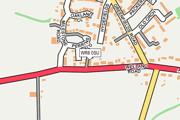
WR8 0SU lies on Welland Road in Upton Upon Severn, Worcester. WR8 0SU is located in the Upton & Ripple electoral ward, within the local authority district of Malvern Hills and the English Parliamentary constituency of West Worcestershire. The Sub Integrated Care Board (ICB) Location is NHS Herefordshire and Worcestershire ICB - 18C and the police force is West Mercia. This postcode has been in use since March 2007.


GetTheData
Source: OS OpenMap – Local (Ordnance Survey)
Source: OS VectorMap District (Ordnance Survey)
Licence: Open Government Licence (requires attribution)
| Easting | 384037 |
| Northing | 239973 |
| Latitude | 52.057905 |
| Longitude | -2.234232 |
GetTheData
Source: Open Postcode Geo
Licence: Open Government Licence
| Street | Welland Road |
| Locality | Upton Upon Severn |
| Town/City | Worcester |
| Country | England |
| Postcode District | WR8 |
➜ See where WR8 is on a map ➜ Where is Upton upon Severn? | |
GetTheData
Source: Land Registry Price Paid Data
Licence: Open Government Licence
Elevation or altitude of WR8 0SU as distance above sea level:
| Metres | Feet | |
|---|---|---|
| Elevation | 30m | 98ft |
Elevation is measured from the approximate centre of the postcode, to the nearest point on an OS contour line from OS Terrain 50, which has contour spacing of ten vertical metres.
➜ How high above sea level am I? Find the elevation of your current position using your device's GPS.
GetTheData
Source: Open Postcode Elevation
Licence: Open Government Licence
| Ward | Upton & Ripple |
| Constituency | West Worcestershire |
GetTheData
Source: ONS Postcode Database
Licence: Open Government Licence
| Milestone Road (Welland Road) | Tunnel Hill | 41m |
| Milestone Road (Welland Road) | Tunnel Hill | 56m |
| The Hill Centre (Milestone Road) | Tunnel Hill | 124m |
| Monsell Lane (Welland Road) | Tunnel Hill | 270m |
| Monsell Lane (Welland Road) | Tunnel Hill | 297m |
GetTheData
Source: NaPTAN
Licence: Open Government Licence
| Percentage of properties with Next Generation Access | 100.0% |
| Percentage of properties with Superfast Broadband | 100.0% |
| Percentage of properties with Ultrafast Broadband | 0.0% |
| Percentage of properties with Full Fibre Broadband | 0.0% |
Superfast Broadband is between 30Mbps and 300Mbps
Ultrafast Broadband is > 300Mbps
| Percentage of properties unable to receive 2Mbps | 0.0% |
| Percentage of properties unable to receive 5Mbps | 0.0% |
| Percentage of properties unable to receive 10Mbps | 0.0% |
| Percentage of properties unable to receive 30Mbps | 0.0% |
GetTheData
Source: Ofcom
Licence: Ofcom Terms of Use (requires attribution)
GetTheData
Source: ONS Postcode Database
Licence: Open Government Licence

➜ Get more ratings from the Food Standards Agency
GetTheData
Source: Food Standards Agency
Licence: FSA terms & conditions
| Last Collection | |||
|---|---|---|---|
| Location | Mon-Fri | Sat | Distance |
| Tunnel Hill | 16:45 | 08:15 | 306m |
| Newbridge Green | 16:30 | 08:30 | 890m |
| Longdon Heath | 16:30 | 09:00 | 1,188m |
GetTheData
Source: Dracos
Licence: Creative Commons Attribution-ShareAlike
The below table lists the International Territorial Level (ITL) codes (formerly Nomenclature of Territorial Units for Statistics (NUTS) codes) and Local Administrative Units (LAU) codes for WR8 0SU:
| ITL 1 Code | Name |
|---|---|
| TLG | West Midlands (England) |
| ITL 2 Code | Name |
| TLG1 | Herefordshire, Worcestershire and Warwickshire |
| ITL 3 Code | Name |
| TLG12 | Worcestershire CC |
| LAU 1 Code | Name |
| E07000235 | Malvern Hills |
GetTheData
Source: ONS Postcode Directory
Licence: Open Government Licence
The below table lists the Census Output Area (OA), Lower Layer Super Output Area (LSOA), and Middle Layer Super Output Area (MSOA) for WR8 0SU:
| Code | Name | |
|---|---|---|
| OA | E00164337 | |
| LSOA | E01032216 | Malvern Hills 011D |
| MSOA | E02006720 | Malvern Hills 011 |
GetTheData
Source: ONS Postcode Directory
Licence: Open Government Licence
| WR8 0EP | Lawnside Close | 34m |
| WR8 0EN | Milestone Road | 87m |
| WR8 0ER | Perrins Field | 98m |
| WR8 0SF | Hydefields | 116m |
| WR8 0SJ | Welland Road | 127m |
| WR8 0SQ | Greenfields | 136m |
| WR8 0ES | Oakland Close | 144m |
| WR8 0ET | Mulberry Drive | 204m |
| WR8 0SG | Packers Hill | 258m |
| WR8 0SH | Old Orchard | 259m |
GetTheData
Source: Open Postcode Geo; Land Registry Price Paid Data
Licence: Open Government Licence