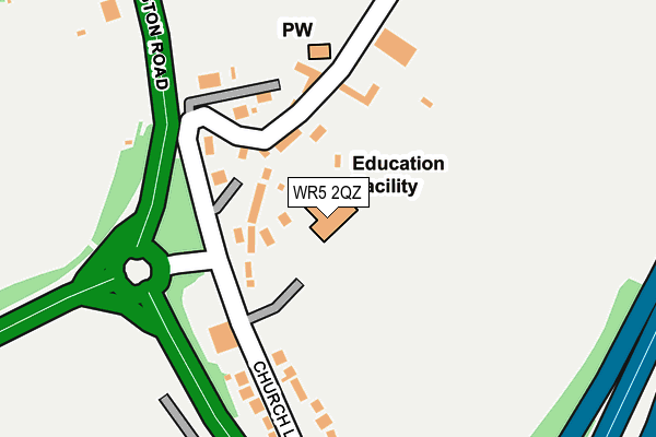
WR5 2QZ is located in the Drakes Broughton, Norton & Whittington electoral ward, within the local authority district of Wychavon and the English Parliamentary constituency of Mid Worcestershire. The Sub Integrated Care Board (ICB) Location is NHS Herefordshire and Worcestershire ICB - 18C and the police force is West Mercia. This postcode has been in use since July 1995.


GetTheData
Source: OS OpenMap – Local (Ordnance Survey)
Source: OS VectorMap District (Ordnance Survey)
Licence: Open Government Licence (requires attribution)
| Easting | 387648 |
| Northing | 252735 |
| Latitude | 52.172734 |
| Longitude | -2.182033 |
GetTheData
Source: Open Postcode Geo
Licence: Open Government Licence
| Country | England |
| Postcode District | WR5 |
➜ See where WR5 is on a map ➜ Where is Whittington? | |
GetTheData
Source: Land Registry Price Paid Data
Licence: Open Government Licence
Elevation or altitude of WR5 2QZ as distance above sea level:
| Metres | Feet | |
|---|---|---|
| Elevation | 60m | 197ft |
Elevation is measured from the approximate centre of the postcode, to the nearest point on an OS contour line from OS Terrain 50, which has contour spacing of ten vertical metres.
➜ How high above sea level am I? Find the elevation of your current position using your device's GPS.
GetTheData
Source: Open Postcode Elevation
Licence: Open Government Licence
| Ward | Drakes Broughton, Norton & Whittington |
| Constituency | Mid Worcestershire |
GetTheData
Source: ONS Postcode Database
Licence: Open Government Licence
| Swan Inn (Whittington Road) | Whittington | 171m |
| Swan Inn (Whittington Road) | Whittington | 240m |
| The Elms (Walkers Lane) | Whittington | 607m |
| Berkeley Close (Walkers Lane) | Whittington | 638m |
| Motorway Junction (Whittington Road (B4084)) | Whittington | 748m |
| Worcester Shrub Hill Station | 3.1km |
| Worcester Foregate Street Station | 3.7km |
GetTheData
Source: NaPTAN
Licence: Open Government Licence
GetTheData
Source: ONS Postcode Database
Licence: Open Government Licence


➜ Get more ratings from the Food Standards Agency
GetTheData
Source: Food Standards Agency
Licence: FSA terms & conditions
| Last Collection | |||
|---|---|---|---|
| Location | Mon-Fri | Sat | Distance |
| The Swan | 16:00 | 09:00 | 119m |
| Berkley Close | 16:00 | 07:00 | 650m |
| Whittington Rd. | 17:30 | 11:30 | 983m |
GetTheData
Source: Dracos
Licence: Creative Commons Attribution-ShareAlike
The below table lists the International Territorial Level (ITL) codes (formerly Nomenclature of Territorial Units for Statistics (NUTS) codes) and Local Administrative Units (LAU) codes for WR5 2QZ:
| ITL 1 Code | Name |
|---|---|
| TLG | West Midlands (England) |
| ITL 2 Code | Name |
| TLG1 | Herefordshire, Worcestershire and Warwickshire |
| ITL 3 Code | Name |
| TLG12 | Worcestershire CC |
| LAU 1 Code | Name |
| E07000238 | Wychavon |
GetTheData
Source: ONS Postcode Directory
Licence: Open Government Licence
The below table lists the Census Output Area (OA), Lower Layer Super Output Area (LSOA), and Middle Layer Super Output Area (MSOA) for WR5 2QZ:
| Code | Name | |
|---|---|---|
| OA | E00165269 | |
| LSOA | E01032403 | Wychavon 009D |
| MSOA | E02006756 | Wychavon 009 |
GetTheData
Source: ONS Postcode Directory
Licence: Open Government Licence
| WR5 2RJ | School Walk | 42m |
| WR5 2RN | Grove Cottages | 67m |
| WR5 2RH | Church Terrace | 82m |
| WR5 2RL | 202m | |
| WR5 2RQ | Church Lane | 274m |
| WR5 2RA | Whittington Road | 356m |
| WR5 2RD | Walkers Lane | 452m |
| WR5 2RF | Berkeley Close | 607m |
| WR5 2RE | Walkers Lane | 643m |
| WR5 2SH | Walkers Lane | 666m |
GetTheData
Source: Open Postcode Geo; Land Registry Price Paid Data
Licence: Open Government Licence