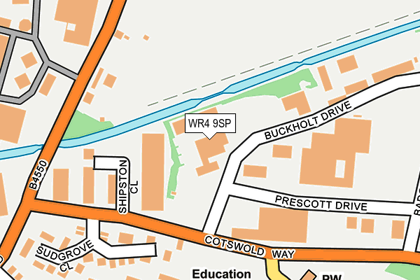
WR4 9SP is located in the Warndon Parish North electoral ward, within the local authority district of Worcester and the English Parliamentary constituency of Worcester. The Sub Integrated Care Board (ICB) Location is NHS Herefordshire and Worcestershire ICB - 18C and the police force is West Mercia. This postcode has been in use since January 1992.


GetTheData
Source: OS OpenMap – Local (Ordnance Survey)
Source: OS VectorMap District (Ordnance Survey)
Licence: Open Government Licence (requires attribution)
| Easting | 386980 |
| Northing | 257651 |
| Latitude | 52.216915 |
| Longitude | -2.191992 |
GetTheData
Source: Open Postcode Geo
Licence: Open Government Licence
| Country | England |
| Postcode District | WR4 |
➜ See where WR4 is on a map ➜ Where is Worcester? | |
GetTheData
Source: Land Registry Price Paid Data
Licence: Open Government Licence
Elevation or altitude of WR4 9SP as distance above sea level:
| Metres | Feet | |
|---|---|---|
| Elevation | 30m | 98ft |
Elevation is measured from the approximate centre of the postcode, to the nearest point on an OS contour line from OS Terrain 50, which has contour spacing of ten vertical metres.
➜ How high above sea level am I? Find the elevation of your current position using your device's GPS.
GetTheData
Source: Open Postcode Elevation
Licence: Open Government Licence
| Ward | Warndon Parish North |
| Constituency | Worcester |
GetTheData
Source: ONS Postcode Database
Licence: Open Government Licence
| Cranham Trading Estate (Cotswold Way) | Blackpole | 141m |
| Cranham Trading Estate (Cotswold Way) | Blackpole | 150m |
| Cranham Drive | Warndon | 272m |
| Blackpole Trading Estate (Blackpole Road) | Blackpole | 282m |
| Cranham Drive | Warndon | 304m |
| Worcester Shrub Hill Station | 2.7km |
| Worcester Foregate Street Station | 3.2km |
GetTheData
Source: NaPTAN
Licence: Open Government Licence
GetTheData
Source: ONS Postcode Database
Licence: Open Government Licence


➜ Get more ratings from the Food Standards Agency
GetTheData
Source: Food Standards Agency
Licence: FSA terms & conditions
| Last Collection | |||
|---|---|---|---|
| Location | Mon-Fri | Sat | Distance |
| Blackpole Trading Estate | 275m | ||
| Winchcombe Drive | 17:15 | 11:30 | 372m |
| Randwick Drive | 17:15 | 11:30 | 499m |
GetTheData
Source: Dracos
Licence: Creative Commons Attribution-ShareAlike
The below table lists the International Territorial Level (ITL) codes (formerly Nomenclature of Territorial Units for Statistics (NUTS) codes) and Local Administrative Units (LAU) codes for WR4 9SP:
| ITL 1 Code | Name |
|---|---|
| TLG | West Midlands (England) |
| ITL 2 Code | Name |
| TLG1 | Herefordshire, Worcestershire and Warwickshire |
| ITL 3 Code | Name |
| TLG12 | Worcestershire CC |
| LAU 1 Code | Name |
| E07000237 | Worcester |
GetTheData
Source: ONS Postcode Directory
Licence: Open Government Licence
The below table lists the Census Output Area (OA), Lower Layer Super Output Area (LSOA), and Middle Layer Super Output Area (MSOA) for WR4 9SP:
| Code | Name | |
|---|---|---|
| OA | E00164915 | |
| LSOA | E01032336 | Worcester 003D |
| MSOA | E02006736 | Worcester 003 |
GetTheData
Source: ONS Postcode Directory
Licence: Open Government Licence
| WR4 9XR | Northleach Close | 187m |
| WR3 8SE | Blackpole Road | 203m |
| WR4 9XJ | Brockhampton Close | 238m |
| WR4 9XS | Sudgrove Close | 272m |
| WR4 9XH | Elkstone Close | 297m |
| WR4 9YF | Burford Close | 319m |
| WR4 9XG | Prestbury Close | 330m |
| WR3 8SG | Blackpole East | 352m |
| WR4 9NA | Leckhampton Close | 354m |
| WR4 9LZ | Cranham Drive | 368m |
GetTheData
Source: Open Postcode Geo; Land Registry Price Paid Data
Licence: Open Government Licence