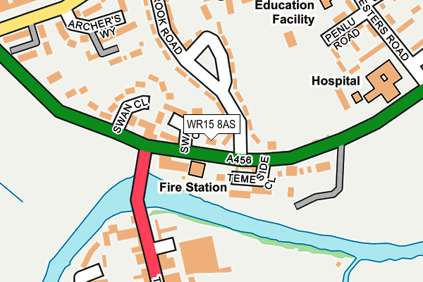
WR15 8AS is located in the Clee electoral ward, within the unitary authority of Shropshire and the English Parliamentary constituency of Ludlow. The Sub Integrated Care Board (ICB) Location is NHS Shropshire, Telford and Wrekin ICB - M2L0M and the police force is West Mercia. This postcode has been in use since January 1980.


GetTheData
Source: OS OpenMap – Local (Ordnance Survey)
Source: OS VectorMap District (Ordnance Survey)
Licence: Open Government Licence (requires attribution)
| Easting | 359654 |
| Northing | 268663 |
| Latitude | 52.314595 |
| Longitude | -2.593264 |
GetTheData
Source: Open Postcode Geo
Licence: Open Government Licence
| Country | England |
| Postcode District | WR15 |
➜ See where WR15 is on a map ➜ Where is Tenbury Wells? | |
GetTheData
Source: Land Registry Price Paid Data
Licence: Open Government Licence
Elevation or altitude of WR15 8AS as distance above sea level:
| Metres | Feet | |
|---|---|---|
| Elevation | 50m | 164ft |
Elevation is measured from the approximate centre of the postcode, to the nearest point on an OS contour line from OS Terrain 50, which has contour spacing of ten vertical metres.
➜ How high above sea level am I? Find the elevation of your current position using your device's GPS.
GetTheData
Source: Open Postcode Elevation
Licence: Open Government Licence
| Ward | Clee |
| Constituency | Ludlow |
GetTheData
Source: ONS Postcode Database
Licence: Open Government Licence
| Swan Garage Temporary Stop (A456) | Tenbury Wells | 78m |
| No. 42 (Stanbrook Road) | Burford | 129m |
| No. 8 (Stanbrook Road) | Burford | 150m |
| Cattle Market Car Park Temporary Stop (Teme Street) | Tenbury Wells | 171m |
| Regal (Teme Street) | Tenbury Wells | 245m |
GetTheData
Source: NaPTAN
Licence: Open Government Licence
| Percentage of properties with Next Generation Access | 100.0% |
| Percentage of properties with Superfast Broadband | 100.0% |
| Percentage of properties with Ultrafast Broadband | 0.0% |
| Percentage of properties with Full Fibre Broadband | 0.0% |
Superfast Broadband is between 30Mbps and 300Mbps
Ultrafast Broadband is > 300Mbps
| Percentage of properties unable to receive 2Mbps | 0.0% |
| Percentage of properties unable to receive 5Mbps | 0.0% |
| Percentage of properties unable to receive 10Mbps | 0.0% |
| Percentage of properties unable to receive 30Mbps | 0.0% |
GetTheData
Source: Ofcom
Licence: Ofcom Terms of Use (requires attribution)
GetTheData
Source: ONS Postcode Database
Licence: Open Government Licence


➜ Get more ratings from the Food Standards Agency
GetTheData
Source: Food Standards Agency
Licence: FSA terms & conditions
| Last Collection | |||
|---|---|---|---|
| Location | Mon-Fri | Sat | Distance |
| Tenbury Wells P.o. | 17:15 | 11:45 | 282m |
| Foresters Road | 16:30 | 08:30 | 291m |
| Clee Hill Road | 16:45 | 08:30 | 505m |
GetTheData
Source: Dracos
Licence: Creative Commons Attribution-ShareAlike
The below table lists the International Territorial Level (ITL) codes (formerly Nomenclature of Territorial Units for Statistics (NUTS) codes) and Local Administrative Units (LAU) codes for WR15 8AS:
| ITL 1 Code | Name |
|---|---|
| TLG | West Midlands (England) |
| ITL 2 Code | Name |
| TLG2 | Shropshire and Staffordshire |
| ITL 3 Code | Name |
| TLG22 | Shropshire |
| LAU 1 Code | Name |
| E06000051 | Shropshire |
GetTheData
Source: ONS Postcode Directory
Licence: Open Government Licence
The below table lists the Census Output Area (OA), Lower Layer Super Output Area (LSOA), and Middle Layer Super Output Area (MSOA) for WR15 8AS:
| Code | Name | |
|---|---|---|
| OA | E00147661 | |
| LSOA | E01028995 | Shropshire 039A |
| MSOA | E02006046 | Shropshire 039 |
GetTheData
Source: ONS Postcode Directory
Licence: Open Government Licence
| WR15 8QF | Swan Court | 63m |
| WR15 8AR | Worcester Road | 73m |
| WR15 8UB | Temeside Close | 92m |
| WR15 8AN | Stanbrook Road | 108m |
| WR15 8AW | Stanbrook Road | 130m |
| WR15 8UD | Swan Close | 132m |
| WR15 8AH | 170m | |
| WR15 8AQ | Teme Street | 198m |
| WR15 8LB | Archers Way | 205m |
| WR15 8AA | Teme Street | 221m |
GetTheData
Source: Open Postcode Geo; Land Registry Price Paid Data
Licence: Open Government Licence