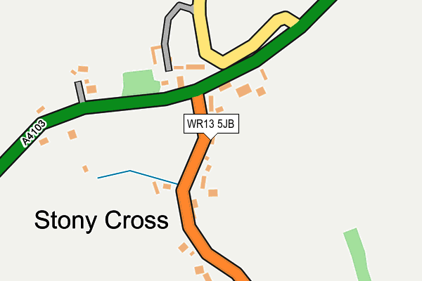
WR13 5JB lies on Stoney Cross in Cradley, Malvern. WR13 5JB is located in the Bishops Frome & Cradley electoral ward, within the unitary authority of Herefordshire, County of and the English Parliamentary constituency of North Herefordshire. The Sub Integrated Care Board (ICB) Location is NHS Herefordshire and Worcestershire ICB - 18C and the police force is West Mercia. This postcode has been in use since January 1980.


GetTheData
Source: OS OpenMap – Local (Ordnance Survey)
Source: OS VectorMap District (Ordnance Survey)
Licence: Open Government Licence (requires attribution)
| Easting | 372514 |
| Northing | 247410 |
| Latitude | 52.124312 |
| Longitude | -2.402893 |
GetTheData
Source: Open Postcode Geo
Licence: Open Government Licence
| Street | Stoney Cross |
| Locality | Cradley |
| Town/City | Malvern |
| Country | England |
| Postcode District | WR13 |
➜ See where WR13 is on a map ➜ Where is Stony Cross? | |
GetTheData
Source: Land Registry Price Paid Data
Licence: Open Government Licence
Elevation or altitude of WR13 5JB as distance above sea level:
| Metres | Feet | |
|---|---|---|
| Elevation | 100m | 328ft |
Elevation is measured from the approximate centre of the postcode, to the nearest point on an OS contour line from OS Terrain 50, which has contour spacing of ten vertical metres.
➜ How high above sea level am I? Find the elevation of your current position using your device's GPS.
GetTheData
Source: Open Postcode Elevation
Licence: Open Government Licence
| Ward | Bishops Frome & Cradley |
| Constituency | North Herefordshire |
GetTheData
Source: ONS Postcode Database
Licence: Open Government Licence
| Birch Cottage (B4220) | Stony Cross | 35m |
| Birch Cottage (B4220) | Stony Cross | 42m |
| Prestons Cross (A4103) | Stony Cross | 73m |
| Prestons Cross (A4103) | Stony Cross | 92m |
| Finchers Corner (B4220. Stony Cross Road) | Cradley | 487m |
| Colwall Station | 5.9km |
GetTheData
Source: NaPTAN
Licence: Open Government Licence
| Percentage of properties with Next Generation Access | 100.0% |
| Percentage of properties with Superfast Broadband | 100.0% |
| Percentage of properties with Ultrafast Broadband | 0.0% |
| Percentage of properties with Full Fibre Broadband | 0.0% |
Superfast Broadband is between 30Mbps and 300Mbps
Ultrafast Broadband is > 300Mbps
| Percentage of properties unable to receive 2Mbps | 0.0% |
| Percentage of properties unable to receive 5Mbps | 0.0% |
| Percentage of properties unable to receive 10Mbps | 0.0% |
| Percentage of properties unable to receive 30Mbps | 0.0% |
GetTheData
Source: Ofcom
Licence: Ofcom Terms of Use (requires attribution)
GetTheData
Source: ONS Postcode Database
Licence: Open Government Licence


➜ Get more ratings from the Food Standards Agency
GetTheData
Source: Food Standards Agency
Licence: FSA terms & conditions
| Last Collection | |||
|---|---|---|---|
| Location | Mon-Fri | Sat | Distance |
| Ridgeway Cross | 16:00 | 09:15 | 233m |
| Finchers Corner | 16:00 | 09:00 | 532m |
| Cradley P.o. | 16:15 | 10:15 | 1,034m |
GetTheData
Source: Dracos
Licence: Creative Commons Attribution-ShareAlike
The below table lists the International Territorial Level (ITL) codes (formerly Nomenclature of Territorial Units for Statistics (NUTS) codes) and Local Administrative Units (LAU) codes for WR13 5JB:
| ITL 1 Code | Name |
|---|---|
| TLG | West Midlands (England) |
| ITL 2 Code | Name |
| TLG1 | Herefordshire, Worcestershire and Warwickshire |
| ITL 3 Code | Name |
| TLG11 | Herefordshire, County of |
| LAU 1 Code | Name |
| E06000019 | Herefordshire, County of |
GetTheData
Source: ONS Postcode Directory
Licence: Open Government Licence
The below table lists the Census Output Area (OA), Lower Layer Super Output Area (LSOA), and Middle Layer Super Output Area (MSOA) for WR13 5JB:
| Code | Name | |
|---|---|---|
| OA | E00070834 | |
| LSOA | E01014030 | Herefordshire 009D |
| MSOA | E02002913 | Herefordshire 009 |
GetTheData
Source: ONS Postcode Directory
Licence: Open Government Licence
| WR13 5JD | Ridgeway Cross | 185m |
| WR13 5JA | Bosbury Road | 220m |
| WR13 5ET | The Farleys | 376m |
| WR13 5LR | 433m | |
| WR13 5HX | Chapel Lane | 436m |
| WR13 5HT | Chapel Orchard | 444m |
| WR13 5JF | Coombe Lane | 459m |
| WR13 5JZ | Huntingdon | 469m |
| WR13 5NW | Stiffords Bridge | 526m |
| WR13 5HZ | Westfields | 530m |
GetTheData
Source: Open Postcode Geo; Land Registry Price Paid Data
Licence: Open Government Licence