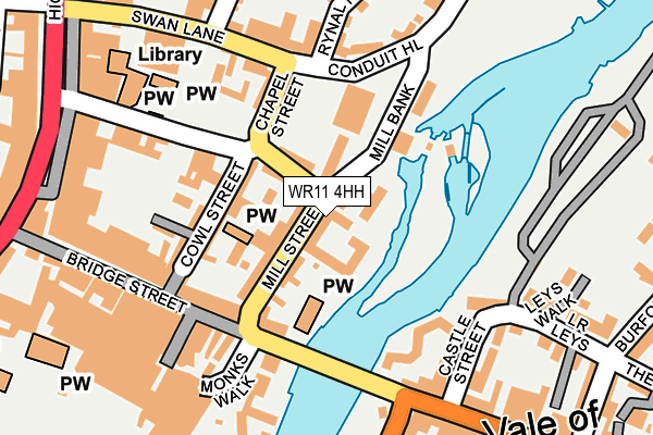
WR11 4HH lies on Mill Street in Evesham. WR11 4HH is located in the Evesham North electoral ward, within the local authority district of Wychavon and the English Parliamentary constituency of Mid Worcestershire. The Sub Integrated Care Board (ICB) Location is NHS Herefordshire and Worcestershire ICB - 18C and the police force is West Mercia. This postcode has been in use since November 2004.


GetTheData
Source: OS OpenMap – Local (Ordnance Survey)
Source: OS VectorMap District (Ordnance Survey)
Licence: Open Government Licence (requires attribution)
| Easting | 403993 |
| Northing | 243821 |
| Latitude | 52.092720 |
| Longitude | -1.943131 |
GetTheData
Source: Open Postcode Geo
Licence: Open Government Licence
| Street | Mill Street |
| Town/City | Evesham |
| Country | England |
| Postcode District | WR11 |
➜ See where WR11 is on a map ➜ Where is Evesham? | |
GetTheData
Source: Land Registry Price Paid Data
Licence: Open Government Licence
Elevation or altitude of WR11 4HH as distance above sea level:
| Metres | Feet | |
|---|---|---|
| Elevation | 30m | 98ft |
Elevation is measured from the approximate centre of the postcode, to the nearest point on an OS contour line from OS Terrain 50, which has contour spacing of ten vertical metres.
➜ How high above sea level am I? Find the elevation of your current position using your device's GPS.
GetTheData
Source: Open Postcode Elevation
Licence: Open Government Licence
| Ward | Evesham North |
| Constituency | Mid Worcestershire |
GetTheData
Source: ONS Postcode Database
Licence: Open Government Licence
| Chapel Street | Evesham | 116m |
| Northwick Hotel (Waterside) | Bengeworth | 285m |
| Northwick Hotel (Waterside) | Bengeworth | 293m |
| Vine Street | Evesham | 330m |
| Avon Street (High Street) | Evesham | 336m |
| Evesham Station | 0.7km |
GetTheData
Source: NaPTAN
Licence: Open Government Licence
| Percentage of properties with Next Generation Access | 100.0% |
| Percentage of properties with Superfast Broadband | 100.0% |
| Percentage of properties with Ultrafast Broadband | 0.0% |
| Percentage of properties with Full Fibre Broadband | 0.0% |
Superfast Broadband is between 30Mbps and 300Mbps
Ultrafast Broadband is > 300Mbps
| Percentage of properties unable to receive 2Mbps | 0.0% |
| Percentage of properties unable to receive 5Mbps | 0.0% |
| Percentage of properties unable to receive 10Mbps | 0.0% |
| Percentage of properties unable to receive 30Mbps | 0.0% |
GetTheData
Source: Ofcom
Licence: Ofcom Terms of Use (requires attribution)
GetTheData
Source: ONS Postcode Database
Licence: Open Government Licence


➜ Get more ratings from the Food Standards Agency
GetTheData
Source: Food Standards Agency
Licence: FSA terms & conditions
| Last Collection | |||
|---|---|---|---|
| Location | Mon-Fri | Sat | Distance |
| The Bridge | 17:30 | 11:00 | 151m |
| Rynal Place | 17:30 | 11:00 | 263m |
| Market Place | 17:30 | 11:00 | 294m |
GetTheData
Source: Dracos
Licence: Creative Commons Attribution-ShareAlike
The below table lists the International Territorial Level (ITL) codes (formerly Nomenclature of Territorial Units for Statistics (NUTS) codes) and Local Administrative Units (LAU) codes for WR11 4HH:
| ITL 1 Code | Name |
|---|---|
| TLG | West Midlands (England) |
| ITL 2 Code | Name |
| TLG1 | Herefordshire, Worcestershire and Warwickshire |
| ITL 3 Code | Name |
| TLG12 | Worcestershire CC |
| LAU 1 Code | Name |
| E07000238 | Wychavon |
GetTheData
Source: ONS Postcode Directory
Licence: Open Government Licence
The below table lists the Census Output Area (OA), Lower Layer Super Output Area (LSOA), and Middle Layer Super Output Area (MSOA) for WR11 4HH:
| Code | Name | |
|---|---|---|
| OA | E00164957 | |
| LSOA | E01032343 | Wychavon 014A |
| MSOA | E02006761 | Wychavon 014 |
GetTheData
Source: ONS Postcode Directory
Licence: Open Government Licence
| WR11 4HL | Mill Street | 12m |
| WR11 4HF | Mill Street | 20m |
| WR11 4HN | Mill Street | 23m |
| WR11 4HE | Mill Street | 33m |
| WR11 4PP | Mill Street | 34m |
| WR11 4HP | Mill Street | 34m |
| WR11 4HU | Mill Street | 37m |
| WR11 4LH | Mill Street | 39m |
| WR11 4HW | Mill Street | 39m |
| WR11 4HX | Mill Street | 48m |
GetTheData
Source: Open Postcode Geo; Land Registry Price Paid Data
Licence: Open Government Licence