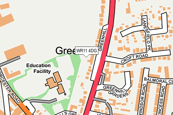
WR11 4DG is located in the Inkberrow electoral ward, within the local authority district of Wychavon and the English Parliamentary constituency of Redditch. The Sub Integrated Care Board (ICB) Location is NHS Herefordshire and Worcestershire ICB - 18C and the police force is West Mercia. This postcode has been in use since October 2016.


GetTheData
Source: OS OpenMap – Local (Ordnance Survey)
Source: OS VectorMap District (Ordnance Survey)
Licence: Open Government Licence (requires attribution)
| Easting | 402326 |
| Northing | 250904 |
| Latitude | 52.156422 |
| Longitude | -1.967409 |
GetTheData
Source: Open Postcode Geo
Licence: Open Government Licence
| Country | England |
| Postcode District | WR11 |
➜ See where WR11 is on a map ➜ Where is Church Lench? | |
GetTheData
Source: Land Registry Price Paid Data
Licence: Open Government Licence
Elevation or altitude of WR11 4DG as distance above sea level:
| Metres | Feet | |
|---|---|---|
| Elevation | 50m | 164ft |
Elevation is measured from the approximate centre of the postcode, to the nearest point on an OS contour line from OS Terrain 50, which has contour spacing of ten vertical metres.
➜ How high above sea level am I? Find the elevation of your current position using your device's GPS.
GetTheData
Source: Open Postcode Elevation
Licence: Open Government Licence
| Ward | Inkberrow |
| Constituency | Redditch |
GetTheData
Source: ONS Postcode Database
Licence: Open Government Licence
1, ORCHARD CLOSE, CHURCH LENCH, EVESHAM, WR11 4DG 2018 22 AUG £620,000 |
2, ORCHARD CLOSE, CHURCH LENCH, EVESHAM, WR11 4DG 2018 5 JUN £600,000 |
GetTheData
Source: HM Land Registry Price Paid Data
Licence: Contains HM Land Registry data © Crown copyright and database right 2025. This data is licensed under the Open Government Licence v3.0.
| Church Lench School (Main Street) | Church Lench | 341m |
| Shelter (Atch Lench Road) | Church Lench | 448m |
| Rous Lench Turn (Atch Lench Road) | Church Lench | 471m |
| Garfield House (Evesham Road) | Church Lench | 541m |
| Beehive Cottage (Low Road) | Church Lench | 789m |
GetTheData
Source: NaPTAN
Licence: Open Government Licence
GetTheData
Source: ONS Postcode Database
Licence: Open Government Licence
➜ Get more ratings from the Food Standards Agency
GetTheData
Source: Food Standards Agency
Licence: FSA terms & conditions
| Last Collection | |||
|---|---|---|---|
| Location | Mon-Fri | Sat | Distance |
| Church Lench P.o. | 16:15 | 09:30 | 373m |
| Atch Lench | 16:00 | 10:00 | 1,032m |
| Abbotts Lench | 16:00 | 09:00 | 1,402m |
GetTheData
Source: Dracos
Licence: Creative Commons Attribution-ShareAlike
The below table lists the International Territorial Level (ITL) codes (formerly Nomenclature of Territorial Units for Statistics (NUTS) codes) and Local Administrative Units (LAU) codes for WR11 4DG:
| ITL 1 Code | Name |
|---|---|
| TLG | West Midlands (England) |
| ITL 2 Code | Name |
| TLG1 | Herefordshire, Worcestershire and Warwickshire |
| ITL 3 Code | Name |
| TLG12 | Worcestershire CC |
| LAU 1 Code | Name |
| E07000238 | Wychavon |
GetTheData
Source: ONS Postcode Directory
Licence: Open Government Licence
The below table lists the Census Output Area (OA), Lower Layer Super Output Area (LSOA), and Middle Layer Super Output Area (MSOA) for WR11 4DG:
| Code | Name | |
|---|---|---|
| OA | E00165209 | |
| LSOA | E01032394 | Wychavon 008C |
| MSOA | E02006755 | Wychavon 008 |
GetTheData
Source: ONS Postcode Directory
Licence: Open Government Licence
| WR11 4UE | Main Street | 283m |
| WR11 4UD | The Croft | 364m |
| WR11 4UQ | Ab Lench Road | 388m |
| WR11 4UF | Malthouse Lane | 433m |
| WR11 4UB | Evesham Road | 467m |
| WR11 4UG | Atch Lench Road | 612m |
| WR11 4SW | 901m | |
| WR11 4UH | Low Road | 921m |
| WR11 4LY | Handgate Lane | 1265m |
| WR11 4SZ | Farm Lane | 1295m |
GetTheData
Source: Open Postcode Geo; Land Registry Price Paid Data
Licence: Open Government Licence