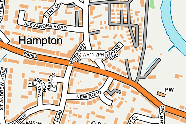
WR11 2PH lies on Pershore Road in Evesham. WR11 2PH is located in the Hampton electoral ward, within the local authority district of Wychavon and the English Parliamentary constituency of Mid Worcestershire. The Sub Integrated Care Board (ICB) Location is NHS Herefordshire and Worcestershire ICB - 18C and the police force is West Mercia. This postcode has been in use since December 2001.


GetTheData
Source: OS OpenMap – Local (Ordnance Survey)
Source: OS VectorMap District (Ordnance Survey)
Licence: Open Government Licence (requires attribution)
| Easting | 402646 |
| Northing | 243206 |
| Latitude | 52.087199 |
| Longitude | -1.962797 |
GetTheData
Source: Open Postcode Geo
Licence: Open Government Licence
| Street | Pershore Road |
| Town/City | Evesham |
| Country | England |
| Postcode District | WR11 |
➜ See where WR11 is on a map ➜ Where is Evesham? | |
GetTheData
Source: Land Registry Price Paid Data
Licence: Open Government Licence
Elevation or altitude of WR11 2PH as distance above sea level:
| Metres | Feet | |
|---|---|---|
| Elevation | 30m | 98ft |
Elevation is measured from the approximate centre of the postcode, to the nearest point on an OS contour line from OS Terrain 50, which has contour spacing of ten vertical metres.
➜ How high above sea level am I? Find the elevation of your current position using your device's GPS.
GetTheData
Source: Open Postcode Elevation
Licence: Open Government Licence
| Ward | Hampton |
| Constituency | Mid Worcestershire |
GetTheData
Source: ONS Postcode Database
Licence: Open Government Licence
| Cider Mill (Pershore Road) | Hampton | 32m |
| Cider Mill (Pershore Road) | Hampton | 36m |
| School Road | Hampton | 69m |
| New Road | Hampton | 98m |
| Peewit Road | Hampton | 105m |
| Evesham Station | 1.6km |
GetTheData
Source: NaPTAN
Licence: Open Government Licence
| Percentage of properties with Next Generation Access | 100.0% |
| Percentage of properties with Superfast Broadband | 100.0% |
| Percentage of properties with Ultrafast Broadband | 0.0% |
| Percentage of properties with Full Fibre Broadband | 0.0% |
Superfast Broadband is between 30Mbps and 300Mbps
Ultrafast Broadband is > 300Mbps
| Percentage of properties unable to receive 2Mbps | 0.0% |
| Percentage of properties unable to receive 5Mbps | 0.0% |
| Percentage of properties unable to receive 10Mbps | 0.0% |
| Percentage of properties unable to receive 30Mbps | 0.0% |
GetTheData
Source: Ofcom
Licence: Ofcom Terms of Use (requires attribution)
GetTheData
Source: ONS Postcode Database
Licence: Open Government Licence


➜ Get more ratings from the Food Standards Agency
GetTheData
Source: Food Standards Agency
Licence: FSA terms & conditions
| Last Collection | |||
|---|---|---|---|
| Location | Mon-Fri | Sat | Distance |
| Hampton P.o. | 17:30 | 11:00 | 87m |
| Evendene Road | 17:30 | 11:00 | 219m |
| Marymans Road | 17:15 | 11:00 | 284m |
GetTheData
Source: Dracos
Licence: Creative Commons Attribution-ShareAlike
The below table lists the International Territorial Level (ITL) codes (formerly Nomenclature of Territorial Units for Statistics (NUTS) codes) and Local Administrative Units (LAU) codes for WR11 2PH:
| ITL 1 Code | Name |
|---|---|
| TLG | West Midlands (England) |
| ITL 2 Code | Name |
| TLG1 | Herefordshire, Worcestershire and Warwickshire |
| ITL 3 Code | Name |
| TLG12 | Worcestershire CC |
| LAU 1 Code | Name |
| E07000238 | Wychavon |
GetTheData
Source: ONS Postcode Directory
Licence: Open Government Licence
The below table lists the Census Output Area (OA), Lower Layer Super Output Area (LSOA), and Middle Layer Super Output Area (MSOA) for WR11 2PH:
| Code | Name | |
|---|---|---|
| OA | E00165179 | |
| LSOA | E01032385 | Wychavon 015C |
| MSOA | E02006762 | Wychavon 015 |
GetTheData
Source: ONS Postcode Directory
Licence: Open Government Licence
| WR11 2NA | Pershore Road | 38m |
| WR11 2PN | Workman Road | 71m |
| WR11 2PW | School Road | 75m |
| WR11 2NG | New Road | 89m |
| WR11 2RL | Peewit Road | 105m |
| WR11 2JY | John Martin Square | 124m |
| WR11 2NH | Peewit Road | 132m |
| WR11 2PQ | Pershore Road | 134m |
| WR11 2RR | Lunns Gardens | 155m |
| WR11 2RP | Basson Court | 156m |
GetTheData
Source: Open Postcode Geo; Land Registry Price Paid Data
Licence: Open Government Licence