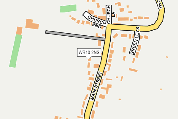
WR10 2NS lies on Dorrells Orchard in Bishampton, Pershore. WR10 2NS is located in the Pinvin electoral ward, within the local authority district of Wychavon and the English Parliamentary constituency of Mid Worcestershire. The Sub Integrated Care Board (ICB) Location is NHS Herefordshire and Worcestershire ICB - 18C and the police force is West Mercia. This postcode has been in use since July 1990.


GetTheData
Source: OS OpenMap – Local (Ordnance Survey)
Source: OS VectorMap District (Ordnance Survey)
Licence: Open Government Licence (requires attribution)
| Easting | 398922 |
| Northing | 251611 |
| Latitude | 52.162769 |
| Longitude | -2.017176 |
GetTheData
Source: Open Postcode Geo
Licence: Open Government Licence
| Street | Dorrells Orchard |
| Locality | Bishampton |
| Town/City | Pershore |
| Country | England |
| Postcode District | WR10 |
➜ See where WR10 is on a map ➜ Where is Bishampton? | |
GetTheData
Source: Land Registry Price Paid Data
Licence: Open Government Licence
Elevation or altitude of WR10 2NS as distance above sea level:
| Metres | Feet | |
|---|---|---|
| Elevation | 40m | 131ft |
Elevation is measured from the approximate centre of the postcode, to the nearest point on an OS contour line from OS Terrain 50, which has contour spacing of ten vertical metres.
➜ How high above sea level am I? Find the elevation of your current position using your device's GPS.
GetTheData
Source: Open Postcode Elevation
Licence: Open Government Licence
| Ward | Pinvin |
| Constituency | Mid Worcestershire |
GetTheData
Source: ONS Postcode Database
Licence: Open Government Licence
2023 1 SEP £767,500 |
2017 2 MAR £485,000 |
2016 16 NOV £490,000 |
2004 1 SEP £420,000 |
1999 21 JUL £287,500 |
2, DORRELLS ORCHARD, BISHAMPTON, PERSHORE, WR10 2NS 1995 28 JUN £246,000 |
GetTheData
Source: HM Land Registry Price Paid Data
Licence: Contains HM Land Registry data © Crown copyright and database right 2025. This data is licensed under the Open Government Licence v3.0.
| Abberton Road | Bishampton | 135m |
| Abberton Road | Bishampton | 145m |
| Dolphin Inn (Main Street) | Bishampton | 173m |
| Dolphin Inn (Main Street) | Bishampton | 178m |
| Post Office (Main Street) | Bishampton | 267m |
| Pershore Station | 5.2km |
GetTheData
Source: NaPTAN
Licence: Open Government Licence
| Percentage of properties with Next Generation Access | 100.0% |
| Percentage of properties with Superfast Broadband | 100.0% |
| Percentage of properties with Ultrafast Broadband | 0.0% |
| Percentage of properties with Full Fibre Broadband | 0.0% |
Superfast Broadband is between 30Mbps and 300Mbps
Ultrafast Broadband is > 300Mbps
| Median download speed | 76.6Mbps |
| Average download speed | 63.1Mbps |
| Maximum download speed | 80.00Mbps |
| Median upload speed | 20.0Mbps |
| Average upload speed | 16.0Mbps |
| Maximum upload speed | 20.00Mbps |
| Percentage of properties unable to receive 2Mbps | 0.0% |
| Percentage of properties unable to receive 5Mbps | 0.0% |
| Percentage of properties unable to receive 10Mbps | 0.0% |
| Percentage of properties unable to receive 30Mbps | 0.0% |
GetTheData
Source: Ofcom
Licence: Ofcom Terms of Use (requires attribution)
GetTheData
Source: ONS Postcode Database
Licence: Open Government Licence


➜ Get more ratings from the Food Standards Agency
GetTheData
Source: Food Standards Agency
Licence: FSA terms & conditions
| Last Collection | |||
|---|---|---|---|
| Location | Mon-Fri | Sat | Distance |
| Church End | 16:00 | 09:00 | 117m |
| Bishampton P.o. | 16:00 | 10:00 | 270m |
| Abberton | 16:00 | 08:30 | 1,852m |
GetTheData
Source: Dracos
Licence: Creative Commons Attribution-ShareAlike
The below table lists the International Territorial Level (ITL) codes (formerly Nomenclature of Territorial Units for Statistics (NUTS) codes) and Local Administrative Units (LAU) codes for WR10 2NS:
| ITL 1 Code | Name |
|---|---|
| TLG | West Midlands (England) |
| ITL 2 Code | Name |
| TLG1 | Herefordshire, Worcestershire and Warwickshire |
| ITL 3 Code | Name |
| TLG12 | Worcestershire CC |
| LAU 1 Code | Name |
| E07000238 | Wychavon |
GetTheData
Source: ONS Postcode Directory
Licence: Open Government Licence
The below table lists the Census Output Area (OA), Lower Layer Super Output Area (LSOA), and Middle Layer Super Output Area (MSOA) for WR10 2NS:
| Code | Name | |
|---|---|---|
| OA | E00165304 | |
| LSOA | E01032410 | Wychavon 010D |
| MSOA | E02006757 | Wychavon 010 |
GetTheData
Source: ONS Postcode Directory
Licence: Open Government Licence
| WR10 2LT | Church End | 116m |
| WR10 2LX | Main Street | 158m |
| WR10 2NF | Green Leys | 160m |
| WR10 2FA | Church Lane | 173m |
| WR10 2LU | Abberton Road | 193m |
| WR10 2NW | Stanton Fields | 271m |
| WR10 2NN | Babylon Lane | 327m |
| WR10 2LY | Broad Lane | 402m |
| WR10 2NH | Main Street | 425m |
| WR10 2NJ | Moat Farm Lane | 613m |
GetTheData
Source: Open Postcode Geo; Land Registry Price Paid Data
Licence: Open Government Licence