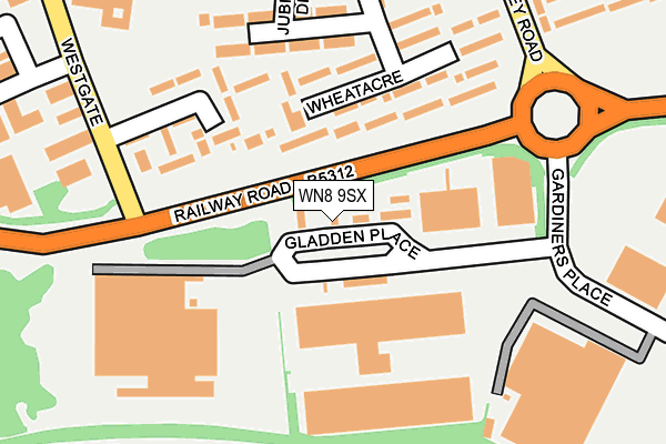
WN8 9SX lies on Gladden Place in Skelmersdale. WN8 9SX is located in the Old Skelmersdale electoral ward, within the local authority district of West Lancashire and the English Parliamentary constituency of West Lancashire. The Sub Integrated Care Board (ICB) Location is NHS Lancashire and South Cumbria ICB - 02G and the police force is Lancashire. This postcode has been in use since January 1980.


GetTheData
Source: OS OpenMap – Local (Ordnance Survey)
Source: OS VectorMap District (Ordnance Survey)
Licence: Open Government Licence (requires attribution)
| Easting | 347131 |
| Northing | 405699 |
| Latitude | 53.545270 |
| Longitude | -2.799334 |
GetTheData
Source: Open Postcode Geo
Licence: Open Government Licence
| Street | Gladden Place |
| Town/City | Skelmersdale |
| Country | England |
| Postcode District | WN8 |
➜ See where WN8 is on a map ➜ Where is Skelmersdale? | |
GetTheData
Source: Land Registry Price Paid Data
Licence: Open Government Licence
Elevation or altitude of WN8 9SX as distance above sea level:
| Metres | Feet | |
|---|---|---|
| Elevation | 70m | 230ft |
Elevation is measured from the approximate centre of the postcode, to the nearest point on an OS contour line from OS Terrain 50, which has contour spacing of ten vertical metres.
➜ How high above sea level am I? Find the elevation of your current position using your device's GPS.
GetTheData
Source: Open Postcode Elevation
Licence: Open Government Licence
| Ward | Old Skelmersdale |
| Constituency | West Lancashire |
GetTheData
Source: ONS Postcode Database
Licence: Open Government Licence
| Westgate (Waldron) | Pennylands | 64m |
| Gladden Place (Railway Road) | Pennylands | 133m |
| Village Inn (High Street) | Pennylands | 226m |
| Gardners Place (Gardiners Place) | Pennylands | 232m |
| Village Inn (High Street) | Pennylands | 234m |
| Rainford Station | 3.2km |
| Upholland Station | 4.3km |
GetTheData
Source: NaPTAN
Licence: Open Government Licence
GetTheData
Source: ONS Postcode Database
Licence: Open Government Licence


➜ Get more ratings from the Food Standards Agency
GetTheData
Source: Food Standards Agency
Licence: FSA terms & conditions
| Last Collection | |||
|---|---|---|---|
| Location | Mon-Fri | Sat | Distance |
| Gillibrands Road Business Box | 739m | ||
| Winsters P O | 18:30 | 11:15 | 786m |
| Skelmersdale Delivery Office | 19:00 | 12:00 | 1,248m |
GetTheData
Source: Dracos
Licence: Creative Commons Attribution-ShareAlike
The below table lists the International Territorial Level (ITL) codes (formerly Nomenclature of Territorial Units for Statistics (NUTS) codes) and Local Administrative Units (LAU) codes for WN8 9SX:
| ITL 1 Code | Name |
|---|---|
| TLD | North West (England) |
| ITL 2 Code | Name |
| TLD4 | Lancashire |
| ITL 3 Code | Name |
| TLD47 | Chorley and West Lancashire |
| LAU 1 Code | Name |
| E07000127 | West Lancashire |
GetTheData
Source: ONS Postcode Directory
Licence: Open Government Licence
The below table lists the Census Output Area (OA), Lower Layer Super Output Area (LSOA), and Middle Layer Super Output Area (MSOA) for WN8 9SX:
| Code | Name | |
|---|---|---|
| OA | E00129519 | |
| LSOA | E01025523 | West Lancashire 011A |
| MSOA | E02005314 | West Lancashire 011 |
GetTheData
Source: ONS Postcode Directory
Licence: Open Government Licence
| WN8 8AJ | Wheatacre | 111m |
| WN8 8AW | Wallcroft Street | 163m |
| WN8 8AL | Waldron | 167m |
| WN8 8AQ | Whitehey | 190m |
| WN8 8AN | Ashwall Street | 208m |
| WN8 8AP | High Street | 238m |
| WN8 8AT | High Street | 259m |
| WN8 8BZ | Birch Street | 266m |
| WN8 8AG | Whitestocks | 270m |
| WN8 8DG | Ann Street | 281m |
GetTheData
Source: Open Postcode Geo; Land Registry Price Paid Data
Licence: Open Government Licence