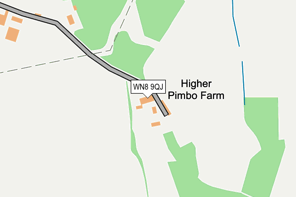
WN8 9QJ lies on Pimbo Lane in Upholland, Skelmersdale. WN8 9QJ is located in the Up Holland electoral ward, within the local authority district of West Lancashire and the English Parliamentary constituency of West Lancashire. The Sub Integrated Care Board (ICB) Location is NHS Lancashire and South Cumbria ICB - 02G and the police force is Lancashire. This postcode has been in use since January 1980.


GetTheData
Source: OS OpenMap – Local (Ordnance Survey)
Source: OS VectorMap District (Ordnance Survey)
Licence: Open Government Licence (requires attribution)
| Easting | 351345 |
| Northing | 403417 |
| Latitude | 53.525168 |
| Longitude | -2.735390 |
GetTheData
Source: Open Postcode Geo
Licence: Open Government Licence
| Street | Pimbo Lane |
| Locality | Upholland |
| Town/City | Skelmersdale |
| Country | England |
| Postcode District | WN8 |
➜ See where WN8 is on a map | |
GetTheData
Source: Land Registry Price Paid Data
Licence: Open Government Licence
Elevation or altitude of WN8 9QJ as distance above sea level:
| Metres | Feet | |
|---|---|---|
| Elevation | 120m | 394ft |
Elevation is measured from the approximate centre of the postcode, to the nearest point on an OS contour line from OS Terrain 50, which has contour spacing of ten vertical metres.
➜ How high above sea level am I? Find the elevation of your current position using your device's GPS.
GetTheData
Source: Open Postcode Elevation
Licence: Open Government Licence
| Ward | Up Holland |
| Constituency | West Lancashire |
GetTheData
Source: ONS Postcode Database
Licence: Open Government Licence
| Industrial Park (Prescot Road) | Pimbo | 610m |
| Priorswood Place (Prescot Road) | Pimbo | 663m |
| Industrial Park (Prescot Road) | Pimbo | 787m |
| Comfort Inn (Prescott Road) | Pimbo | 848m |
| Comfort Inn (Prescott Road) | Pimbo | 871m |
| Upholland Station | 0.5km |
| Orrell Station | 1.9km |
| Rainford Station | 3.7km |
GetTheData
Source: NaPTAN
Licence: Open Government Licence
| Percentage of properties with Next Generation Access | 100.0% |
| Percentage of properties with Superfast Broadband | 100.0% |
| Percentage of properties with Ultrafast Broadband | 100.0% |
| Percentage of properties with Full Fibre Broadband | 100.0% |
Superfast Broadband is between 30Mbps and 300Mbps
Ultrafast Broadband is > 300Mbps
| Percentage of properties unable to receive 2Mbps | 0.0% |
| Percentage of properties unable to receive 5Mbps | 0.0% |
| Percentage of properties unable to receive 10Mbps | 0.0% |
| Percentage of properties unable to receive 30Mbps | 0.0% |
GetTheData
Source: Ofcom
Licence: Ofcom Terms of Use (requires attribution)
GetTheData
Source: ONS Postcode Database
Licence: Open Government Licence


➜ Get more ratings from the Food Standards Agency
GetTheData
Source: Food Standards Agency
Licence: FSA terms & conditions
| Last Collection | |||
|---|---|---|---|
| Location | Mon-Fri | Sat | Distance |
| Bankes Avenue | 18:10 | 12:20 | 1,295m |
| Upholland P O | 18:30 | 11:30 | 1,938m |
| Pimbo Lane | 17:30 | 08:00 | 2,390m |
GetTheData
Source: Dracos
Licence: Creative Commons Attribution-ShareAlike
The below table lists the International Territorial Level (ITL) codes (formerly Nomenclature of Territorial Units for Statistics (NUTS) codes) and Local Administrative Units (LAU) codes for WN8 9QJ:
| ITL 1 Code | Name |
|---|---|
| TLD | North West (England) |
| ITL 2 Code | Name |
| TLD4 | Lancashire |
| ITL 3 Code | Name |
| TLD47 | Chorley and West Lancashire |
| LAU 1 Code | Name |
| E07000127 | West Lancashire |
GetTheData
Source: ONS Postcode Directory
Licence: Open Government Licence
The below table lists the Census Output Area (OA), Lower Layer Super Output Area (LSOA), and Middle Layer Super Output Area (MSOA) for WN8 9QJ:
| Code | Name | |
|---|---|---|
| OA | E00129568 | |
| LSOA | E01025535 | West Lancashire 015B |
| MSOA | E02005318 | West Lancashire 015 |
GetTheData
Source: ONS Postcode Directory
Licence: Open Government Licence
| WN8 9QQ | Pimbo Lane | 533m |
| WN8 9QB | Priorswood Place | 679m |
| WN8 9QL | Pimbo Lane | 799m |
| WN8 0DR | Tower Nook | 822m |
| WN8 9QG | Chequer Close | 862m |
| WN8 9QE | Prestwood Place | 929m |
| WN8 9QD | Prospect Place | 966m |
| WA11 8RP | Crank Road | 1009m |
| WN5 7FP | Gauntley Gardens | 1009m |
| WN5 7FQ | Moorfield Meadow | 1037m |
GetTheData
Source: Open Postcode Geo; Land Registry Price Paid Data
Licence: Open Government Licence