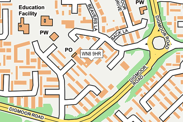
WN8 9HR is located in the Skelmersdale South electoral ward, within the local authority district of West Lancashire and the English Parliamentary constituency of West Lancashire. The Sub Integrated Care Board (ICB) Location is NHS Lancashire and South Cumbria ICB - 02G and the police force is Lancashire. This postcode has been in use since January 1980.


GetTheData
Source: OS OpenMap – Local (Ordnance Survey)
Source: OS VectorMap District (Ordnance Survey)
Licence: Open Government Licence (requires attribution)
| Easting | 349880 |
| Northing | 404777 |
| Latitude | 53.537254 |
| Longitude | -2.757704 |
GetTheData
Source: Open Postcode Geo
Licence: Open Government Licence
| Country | England |
| Postcode District | WN8 |
➜ See where WN8 is on a map ➜ Where is Skelmersdale? | |
GetTheData
Source: Land Registry Price Paid Data
Licence: Open Government Licence
Elevation or altitude of WN8 9HR as distance above sea level:
| Metres | Feet | |
|---|---|---|
| Elevation | 80m | 262ft |
Elevation is measured from the approximate centre of the postcode, to the nearest point on an OS contour line from OS Terrain 50, which has contour spacing of ten vertical metres.
➜ How high above sea level am I? Find the elevation of your current position using your device's GPS.
GetTheData
Source: Open Postcode Elevation
Licence: Open Government Licence
| Ward | Skelmersdale South |
| Constituency | West Lancashire |
GetTheData
Source: ONS Postcode Database
Licence: Open Government Licence
| Shopping Parade (Digmoor Road) | Digmoor | 131m |
| Birkrig (Digmoor Road) | Digmoor | 158m |
| Digmoor Road | Digmoor | 349m |
| Digmoor Road | Clay Brow | 370m |
| Cherrycroft (Clay Brow Road) | Clay Brow | 421m |
| Upholland Station | 1.5km |
| Rainford Station | 3.1km |
| Orrell Station | 3.3km |
GetTheData
Source: NaPTAN
Licence: Open Government Licence
| Median download speed | 18.7Mbps |
| Average download speed | 29.8Mbps |
| Maximum download speed | 80.00Mbps |
| Median upload speed | 3.8Mbps |
| Average upload speed | 8.0Mbps |
| Maximum upload speed | 20.00Mbps |
GetTheData
Source: Ofcom
Licence: Ofcom Terms of Use (requires attribution)
GetTheData
Source: ONS Postcode Database
Licence: Open Government Licence


➜ Get more ratings from the Food Standards Agency
GetTheData
Source: Food Standards Agency
Licence: FSA terms & conditions
| Last Collection | |||
|---|---|---|---|
| Location | Mon-Fri | Sat | Distance |
| Martins Lane | 17:30 | 11:00 | 569m |
| 83 Banksbarn | 17:35 | 11:00 | 577m |
| Skelmersdale Delivery Office | 19:00 | 12:00 | 1,724m |
GetTheData
Source: Dracos
Licence: Creative Commons Attribution-ShareAlike
The below table lists the International Territorial Level (ITL) codes (formerly Nomenclature of Territorial Units for Statistics (NUTS) codes) and Local Administrative Units (LAU) codes for WN8 9HR:
| ITL 1 Code | Name |
|---|---|
| TLD | North West (England) |
| ITL 2 Code | Name |
| TLD4 | Lancashire |
| ITL 3 Code | Name |
| TLD47 | Chorley and West Lancashire |
| LAU 1 Code | Name |
| E07000127 | West Lancashire |
GetTheData
Source: ONS Postcode Directory
Licence: Open Government Licence
The below table lists the Census Output Area (OA), Lower Layer Super Output Area (LSOA), and Middle Layer Super Output Area (MSOA) for WN8 9HR:
| Code | Name | |
|---|---|---|
| OA | E00129428 | |
| LSOA | E01025504 | West Lancashire 014D |
| MSOA | E02005317 | West Lancashire 014 |
GetTheData
Source: ONS Postcode Directory
Licence: Open Government Licence
| WN8 9HP | Birkrig | 42m |
| WN8 9BS | Birleywood | 49m |
| WN8 9HY | Birkrig | 84m |
| WN8 9HW | Birkrig | 115m |
| WN8 9BX | Back Lane | 125m |
| WN8 9HZ | Birkrig | 131m |
| WN8 9BU | Birleywood | 150m |
| WN8 9HL | Birkrig | 160m |
| WN8 9BP | Beavers Lane | 169m |
| WN8 9DL | Carfield | 212m |
GetTheData
Source: Open Postcode Geo; Land Registry Price Paid Data
Licence: Open Government Licence