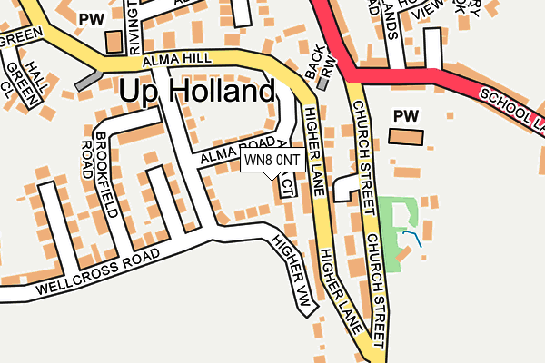
WN8 0NT lies on Alma Court in Upholland, Skelmersdale. WN8 0NT is located in the Up Holland electoral ward, within the local authority district of West Lancashire and the English Parliamentary constituency of West Lancashire. The Sub Integrated Care Board (ICB) Location is NHS Lancashire and South Cumbria ICB - 02G and the police force is Lancashire. This postcode has been in use since January 1980.


GetTheData
Source: OS OpenMap – Local (Ordnance Survey)
Source: OS VectorMap District (Ordnance Survey)
Licence: Open Government Licence (requires attribution)
| Easting | 352170 |
| Northing | 405055 |
| Latitude | 53.539950 |
| Longitude | -2.723198 |
GetTheData
Source: Open Postcode Geo
Licence: Open Government Licence
| Street | Alma Court |
| Locality | Upholland |
| Town/City | Skelmersdale |
| Country | England |
| Postcode District | WN8 |
➜ See where WN8 is on a map ➜ Where is Up Holland? | |
GetTheData
Source: Land Registry Price Paid Data
Licence: Open Government Licence
Elevation or altitude of WN8 0NT as distance above sea level:
| Metres | Feet | |
|---|---|---|
| Elevation | 110m | 361ft |
Elevation is measured from the approximate centre of the postcode, to the nearest point on an OS contour line from OS Terrain 50, which has contour spacing of ten vertical metres.
➜ How high above sea level am I? Find the elevation of your current position using your device's GPS.
GetTheData
Source: Open Postcode Elevation
Licence: Open Government Licence
| Ward | Up Holland |
| Constituency | West Lancashire |
GetTheData
Source: ONS Postcode Database
Licence: Open Government Licence
| Alma Hill | Hall Green | 227m |
| Parliament Street | Up Holland | 256m |
| Parliament Street | Up Holland | 259m |
| Owl Inn (School Lane) | Up Holland | 275m |
| Owl Inn (School Lane) | Up Holland | 291m |
| Orrell Station | 1.4km |
| Upholland Station | 1.8km |
| Gathurst Station | 2.9km |
GetTheData
Source: NaPTAN
Licence: Open Government Licence
| Percentage of properties with Next Generation Access | 100.0% |
| Percentage of properties with Superfast Broadband | 100.0% |
| Percentage of properties with Ultrafast Broadband | 0.0% |
| Percentage of properties with Full Fibre Broadband | 0.0% |
Superfast Broadband is between 30Mbps and 300Mbps
Ultrafast Broadband is > 300Mbps
| Median download speed | 18.4Mbps |
| Average download speed | 33.8Mbps |
| Maximum download speed | 76.85Mbps |
| Median upload speed | 1.1Mbps |
| Average upload speed | 7.0Mbps |
| Maximum upload speed | 20.00Mbps |
| Percentage of properties unable to receive 2Mbps | 0.0% |
| Percentage of properties unable to receive 5Mbps | 0.0% |
| Percentage of properties unable to receive 10Mbps | 0.0% |
| Percentage of properties unable to receive 30Mbps | 0.0% |
GetTheData
Source: Ofcom
Licence: Ofcom Terms of Use (requires attribution)
Estimated total energy consumption in WN8 0NT by fuel type, 2015.
| Consumption (kWh) | 137,923 |
|---|---|
| Meter count | 16 |
| Mean (kWh/meter) | 8,620 |
| Median (kWh/meter) | 8,174 |
| Consumption (kWh) | 24,887 |
|---|---|
| Meter count | 11 |
| Mean (kWh/meter) | 2,262 |
| Median (kWh/meter) | 1,945 |
GetTheData
Source: Postcode level gas estimates: 2015 (experimental)
Source: Postcode level electricity estimates: 2015 (experimental)
Licence: Open Government Licence
GetTheData
Source: ONS Postcode Database
Licence: Open Government Licence


➜ Get more ratings from the Food Standards Agency
GetTheData
Source: Food Standards Agency
Licence: FSA terms & conditions
| Last Collection | |||
|---|---|---|---|
| Location | Mon-Fri | Sat | Distance |
| Upholland P O | 18:30 | 11:30 | 377m |
| Bankes Avenue | 18:10 | 12:20 | 859m |
| 12 Roby Mill | 18:30 | 11:00 | 2,292m |
GetTheData
Source: Dracos
Licence: Creative Commons Attribution-ShareAlike
The below table lists the International Territorial Level (ITL) codes (formerly Nomenclature of Territorial Units for Statistics (NUTS) codes) and Local Administrative Units (LAU) codes for WN8 0NT:
| ITL 1 Code | Name |
|---|---|
| TLD | North West (England) |
| ITL 2 Code | Name |
| TLD4 | Lancashire |
| ITL 3 Code | Name |
| TLD47 | Chorley and West Lancashire |
| LAU 1 Code | Name |
| E07000127 | West Lancashire |
GetTheData
Source: ONS Postcode Directory
Licence: Open Government Licence
The below table lists the Census Output Area (OA), Lower Layer Super Output Area (LSOA), and Middle Layer Super Output Area (MSOA) for WN8 0NT:
| Code | Name | |
|---|---|---|
| OA | E00129584 | |
| LSOA | E01025537 | West Lancashire 015D |
| MSOA | E02005318 | West Lancashire 015 |
GetTheData
Source: ONS Postcode Directory
Licence: Open Government Licence
| WN8 0NQ | Alma Parade | 42m |
| WN8 0NL | Higher Lane | 44m |
| WN8 0NE | St Thomas Court | 63m |
| WN8 0NH | Alma Road | 64m |
| WN8 0NS | Alma Hill | 68m |
| WN8 0ND | Church Street | 107m |
| WN8 0NJ | Alma Walk | 119m |
| WN8 0NW | Alma Hill | 132m |
| WN8 0NX | Heatherlea Close | 138m |
| WN8 0NZ | Brookfield Road | 178m |
GetTheData
Source: Open Postcode Geo; Land Registry Price Paid Data
Licence: Open Government Licence